
Bautzen district
| coat of arms | Germany map |
|---|---|

|

Coordinates: 51 ° 11 ′ N , 14 ° 26 ′ E |
| Basic data | |
| State : | Saxony |
| Administrative headquarters : | Bautzen |
| Area : | 2,395.61 km 2 |
| Residents: | 299,758 (Dec. 31, 2019) |
| Population density : | 125 inhabitants per km 2 |
| License plate : | BZ, BIW, HY, KM |
| Circle key : | 14 6 25 |
| NUTS : | DED2C |
| Circle structure: | 57 municipalities |
| Address of the district administration: |
Bahnhofstrasse 9 02625 Bautzen |
| Website : | |
| District Administrator : | Michael Harig ( CDU ) |
| Location of the Bautzen district in Saxony | |
  |
|
The district of Bautzen ( Upper Sorbian Wokrjes Budyšin ) in Eastern Saxony is the largest district in the Free State in terms of area with Bautzen , Bischofswerda , Kamenz , Hoyerswerda and Radeberg as major district towns. It borders Brandenburg in the north, the Görlitz district in the east, the Czech Republic and the Saxon Switzerland-Eastern Ore Mountains district in the south . The western neighbors are the state capital Dresden and the district of Meißen . The district is a member of the Neisse Euroregion .
geography
The district stretches from the Brandenburg border over the Upper Lusatian heath and pond landscape and the Lusatian mountains around Wilthen and Cunewalde (colloquially referred to as Oberland ) to the Czech border at Sohland on the Spree . The highest point is the Valtenberg (587 m) near Neukirch / Lausitz . The largest north-south expansion of the district is approx. 63 km and the largest east-west expansion approx. 65 km.
The largest river in the district is the Spree , which flows through Bautzen. Smaller rivers are the Spreearm Kleine Spree , the Schwarzwasser , the Löbauer Wasser , the Schwarze Elster , the Große Röder and the Wesenitz , on which Bischofswerda is located. The largest body of water in terms of area is the Lohsa II reservoir near Lohsa . In the center of the district there are numerous ponds and lakes that were created for fishing purposes.
The 2390 km² district area is predominantly covered with pine forest in the north, the middle part is intensively cultivated, while spruce or mixed forests predominate in the Lausitzer Bergland.
The main area of the district is in Neudörfel (municipality of Räckelwitz ).
See also: List of Landscapes in Saxony , Category: Waters in the Bautzen District , Natural Areas in Saxony
Economy and Transport
economy
In the Future Atlas 2019 , the district of Bautzen was ranked 294th out of 402 districts and urban districts in Germany, making it one of the regions with “balanced opportunities and risks”. The district of Bautzen has increased by 24 places since the last forecast. In 2016, the district was still considered a region with “future risks”.
Street
By the county extend the federal roads 6 ( Dresden -Bautzen- Görlitz ), 96 ( Hoyerswerda -Bautzen- Zittau ), 97 ( Cottbus -Dresden), 98 ( time grove - Laußnitz and Bischofswerda - Oppach ) and 156 ( white water - Bautzen ). In addition, the Autobahn 4 (Dresden – Görlitz) runs for 65.22 km over the area of the district. There are ten connection points in this, namely Hermsdorf , Ottendorf-Okrilla , Pulsnitz , Ohorn , Burkau , Uhyst am Taucher , Salzenforst , Bautzen-West , Bautzen-Ost and Weißenberg .
air
There is a commercial airport in Litten east of Bautzen and near Kamenz , special airfields in Klix , Nardt near Hoyerswerda and Brauna . The Dresden airport is located in close proximity to the western county boundary.
train
The backbone of the railway connections in the Bautzen district is the Dresden – Görlitz railway via Radeberg, Bischofswerda and Bautzen, from which the Dresden-Klotzsche – Königsbrück , Arnsdorf – Kamenz and Bischofswerda – Zittau lines branch off. In the north, the Węgliniec – Ruhland (–Rosslau) railway crosses the district via Hoyerswerda.
In passenger transport, regional trains from the companies DB Regio , Die Länderbahn ( trilex ), Städtebahn Sachsen and ODEG run on these routes , as well as S-Bahn Mitteldeutschland trains on the route to Hoyerswerda . Long-distance trains no longer run on these routes.
Public transport
The rest of the district is served by regional bus routes. As a result of the district reform, the district is divided into two transport associations. The old district of Kamenz and Hoyerswerda are part of the Upper Elbe Transport Association (VVO), the Altland district of Bautzen is part of the Upper Lusatia-Lower Silesia Transport Association (ZVON).
Protected areas
There are 20 designated nature reserves in the district (as of February 2017).
history
The district received its present form on August 1, 2008, when the districts of Bautzen and Kamenz and the city of Hoyerswerda, which has been independent since 1996, were merged as part of the Saxony 2008 district reform .
On May 25, 2009, the district received the title “ Place of Diversity ” awarded by the federal government .
See also: Upper Lusatia
Population development


Since reunification, there has been a steady decline in population in what is now the Bautzen district.
| Population development | ||||
|---|---|---|---|---|
| was standing | Residents | was standing | Residents | |
| 3rd October 1990 |
392.132 | December 31, 2011 | 313,618 | |
| December 31, 1995 | 374.309 | December 31, 2012 | 310,898 | |
| December 31, 2000 | 363,677 | September 30th, 2013 | 309.058 | |
| December 31, 2003 | 350,077 | December 31, 2014 | 306,570 | |
| December 31, 2005 | 342.712 | December 31, 2015 | 303.273 | |
| December 31, 2007 | 333,470 | December 31, 2016 | 304,691 | |
| December 31, 2009 | 325.032 | December 31, 2017 | 302.634 | |
| December 31, 2010 | 321,511 | December 31, 2018 | 300,880 | |
| May 9, 2011 |
315.174 | |||
- ↑ The territorial status of the Bautzen district as of January 1, 2014.
politics
District Administrator
In the district election on June 7, 2015, Michael Harig (CDU) prevailed with 72.4% of the votes against Jens Bitzka (B90 / Greens, SPD, Left). Harig has been the district administrator of the Bautzen district since 2001.
District council
The district council of the Bautzen district was last elected on May 25, 2019. The 98 seats in the district council are distributed among the individual parties as follows:
| Parties and constituencies | Percent 2019 |
Seats 2019 |
Percent 2014 |
Seats 2014 |
|
|---|---|---|---|---|---|
| AfD | Alternative for Germany | 29.4 | 29 | 1.3 | 1 |
| CDU | Christian Democratic Union of Germany | 29.1 | 29 | 44.4 | 45 |
| THE LEFT. | THE LEFT. | 10.3 | 10 | 17.5 | 18th |
| FW | Free voters in the Bautzen district association | 10.0 | 10 | 8.7 | 9 |
| SPD | Social Democratic Party of Germany | 8.4 | 8th | 10.9 | 11 |
| FDP | Free Democratic Party | 6.1 | 6th | 5.1 | 5 |
| GREEN | Alliance 90 / The Greens | 5.1 | 5 | 3.7 | 3 |
| SWZ / SWV | Serbske wolerske zjednoćenstwo / Sorbian voters' association | 1.4 | 1 | 1.8 | 1 |
| LA | Lusatian Alliance | 0.1 | - | - | - |
| NPD | National Democratic Party of Germany | - | - | 5.7 | 5 |
| total | 100.0 | 98 | 100.0 | 98 | |
| Turnout in percent | 64.7 | 52.1 | |||
After the local elections in 2019, the following parliamentary groups formed in the district council: AfD (29 members), CDU (29 members), FW (incl. SWZ / SWV, 11 members), DIE LINKE. (10 members), SPD (8 members), FDP (6 members) and GRÜNE (5 members).
District partnerships
-
 Main-Tauber-Kreis , Baden-Württemberg, since 1990
cities and communes
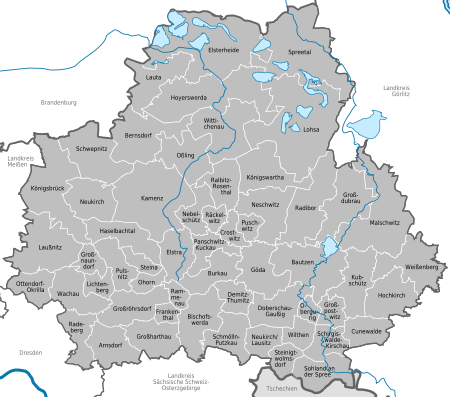
All independent political units of the district are named below. All settlements can be found in the list of places in the Bautzen district . The population is as of December 31, 2019. Sorbian community names in italics do not have an official status.

| Community name (German) | Municipality name (Sorbian) | Community type | VG / VV | Residents | Area (km²) | Inhabitants per km² | Post Code | Telephone code |
|---|---|---|---|---|---|---|---|---|
| Arnsdorf | local community | 4867 | 35.8 | 131 | 01477 | 035200 | ||
| Bautzen | Budyšin | Great county seat | 38,425 | 66.6 | 612 | 02625 | 03591, 035935 | |
| Bernsdorf | Njedźichow | city | 6422 | 59.6 | 116 | 02994 | 035723 | |
| Bischofswerda | Biscopicy | Great county seat | Bischofswerda | 10,938 | 46.3 | 264 | 01877 | 03594 |
| Burkau | Porchow | local community | 2605 | 31.8 | 90 | 01906 | 035953 | |
| Crostwitz | Chrósćicy | local community | At the monastery water | 1025 | 13.3 | 83 | 01920 | 035796 |
| Cunewalde | Kumwałd | local community | 4593 | 26.6 | 195 | 02733 | 035877 | |
| Demitz-Thumitz | Zemicy-Tumicy | local community | 2634 | 21.1 | 139 | 01877 | 03594, 035930, 035953 | |
| Doberschau-Gaussig | Dobruša Huska | local community | 4135 | 40.5 | 110 | 01877, 02633, 02692 | 03591, 03592, 035930 | |
| Elsterheide | Halštrowska hola | local community | 3463 | 126.8 | 30th | 02979 | 03564, 03571 | |
| Elstra | Halštrov | city | 2723 | 32.6 | 90 | 01920 | 035793 | |
| Frankenthal | local community | Großharthau | 923 | 9.4 | 107 | 01909 | 035954 | |
| Goeda | Hodzij | local community | 3063 | 43.3 | 76 | 02633 | 035930 | |
| Grand Dubrau | Wulka Dubrawa | local community | 4249 | 54.2 | 81 | 02694 | 035932, 035934 | |
| Großharthau | local community | Großharthau | 2793 | 37.3 | 85 | 01909 | 035200, 035954 | |
| Grossnaundorf | local community | Pulsnitz | 958 | 15th | 69 | 01936 | 035955 | |
| Großpostwitz | Budestecy | local community | Großpostwitz-Obergurig | 2741 | 16.4 | 179 | 02692 | 035938 |
| Großröhrsdorf | city | 9615 | 41.0 | 233 | 01900 | 035952 | ||
| Haselbachtal | local community | 4013 | 37.5 | 116 | 01920 | 03578 | ||
| Hochkirch | Bukecy | local community | 2256 | 41.7 | 59 | 02627 | 035939 | |
| Hoyerswerda | Wojerecy | Great county seat | 32,405 | 95.1 | 402 | 02977 | 03571, 035722 | |
| Kamenz | Kamjenc | Great county seat | 16,914 | 53.2 | 323 | 01917 | 03578 | |
| Koenigsbrück | Kinspork | city | Koenigsbrück | 4539 | 77.8 | 58 | 01936 | 035795 |
| Königswartha | Rakecy | local community | 3458 | 47 | 81 | 02699 | 035931 | |
| Kubschütz | Kubšicy | local community | 2529 | 43.5 | 64 | 02627 | 03591 | |
| Laußnitz | Łužnica | local community | Koenigsbrück | 1852 | 63.7 | 31 | 01936 | 035795 |
| Lauta | Łuty | city | 8363 | 41.9 | 226 | 02991 | 035722 | |
| Lichtenberg | local community | Pulsnitz | 1618 | 14.8 | 114 | 01896 | 035955 | |
| Lohsa | Łaz | local community | 5232 | 134.2 | 44 | 02999 | 035724, 035726 | |
| Malschwitz | Malešecy | local community | 4643 | 93.2 | 54 | 02694 | 035932, 03591 | |
| Nebelschütz | Njebjelčicy | local community | At the monastery water | 1226 | 22.9 | 53 | 01920 | 03578 |
| Neschwitz | Njeswačidło | local community | Neschwitz | 2401 | 46 | 54 | 02699 | 035933, 035937 |
| Neukirch | local community | Koenigsbrück | 1619 | 39.5 | 44 | 01936 | 035795 | |
| Neukirch / Lausitz | Wjazońca | local community | 4847 | 21.3 | 248 | 01904 | 035951 | |
| Upper mountain | Hornja Hórka | local community | Großpostwitz-Obergurig | 2070 | 9.8 | 219 | 02692 | 035938 |
| Ohorn | local community | Pulsnitz | 2454 | 12.1 | 201 | 01896 | 035955 | |
| Oßling | Wóslink | local community | 2260 | 43.6 | 57 | 01920 | 035792 | |
| Ottendorf-Okrilla | local community | 9980 | 25.9 | 383 | 01458 | 035205 | ||
| Panschwitz-Kuckau | Pančicy-Kukow | local community | At the monastery water | 2090 | 23.4 | 92 | 01900 | 035796 |
| Pulsnitz | Połčnica | city | Pulsnitz | 7468 | 26.7 | 290 | 01896 | 035955 |
| Pushwitz | Bóšicy | local community | Neschwitz | 820 | 11.7 | 81 | 02699 | 035933 |
| Räckelwitz | Worklecy | local community | At the monastery water | 1131 | 11.5 | 102 | 01920 | 035796 |
| Radeberg | Great county seat | 18,565 | 29.7 | 617 | 01454 | 03528 | ||
| Radibor | Radwor | local community | 3119 | 61.9 | 55 | 02627 | 035935 | |
| Ralbitz-Rosenthal | Ralbicy-Róžant | local community | At the monastery water | 1702 | 31.7 | 55 | 01900 | 035796 |
| Rammenau | Ramnow | local community | Bischofswerda | 1338 | 10.8 | 136 | 01877 | 03594 |
| Schirgiswalde-Kirschau | Šěrachow-Korzym | city | 6185 | 24.3 | 274 | 02681 | 03592, 035938 | |
| Schmölln-Putzkau | Smělna-Póckowy | local community | 3006 | 32.9 | 99 | 01877 | 03594 | |
| Schwepnitz | Sepicy | local community | 2478 | 55.5 | 47 | 01936 | 035797 | |
| Sohland | Załom | local community | 6743 | 37.3 | 195 | 02686-02689 | 035936 | |
| Spreetal | Sprjewiny Doł | local community | 1845 | 108.8 | 19th | 02979 | 035727 | |
| Steina | Sćenjow | local community | Pulsnitz | 1627 | 12.5 | 141 | 01920 | 035955 |
| Steinigtwolmsdorf | Wołbramecy | local community | 2811 | 18th | 177 | 01904 | 035951 | |
| Wachau | local community | 4273 | 38.1 | 117 | 01454 | 03528, 035205 | ||
| Weissenberg | Wóspork | city | 3096 | 50.9 | 67 | 02627 | 035876 | |
| Wilthen | Wjelećin | city | 4881 | 17.1 | 333 | 02679-02681 | 03592 | |
| Wittichenau | Kulow | city | 5729 | 60.7 | 99 | 02997 | 035725 |
License Plate
On August 1, 2008, the district was assigned the BZ distinctive sign , which had been valid since January 1, 1991 for the then Bautzen district. Since November 9, 2012, the license plate liberalization has also made the distinguishing marks BIW (Bischofswerda), HY (Hoyerswerda) and KM (Kamenz) available.
See also
- District reforms in Germany after 1990
- List of coats of arms in the Bautzen district
- List of cultural monuments in the Bautzen district
Individual evidence
- ↑ Population of the Free State of Saxony by municipalities on December 31, 2019 ( help on this ).
- ↑ Uwe Menschner: The focus is difficult to find ; in: Oberlausitzer Kurier from September 6, 2008
- ^ Politics national »News to the federal government and the states | Handelsblatt. Retrieved July 25, 2019 .
- ↑ Future Atlas 2016. (No longer available online.) Archived from the original on October 2, 2017 ; accessed on March 23, 2018 . Info: The archive link was inserted automatically and has not yet been checked. Please check the original and archive link according to the instructions and then remove this notice.
- ↑ Database 2011 census, Bautzen, district, age + gender
- ↑ State Statistical Office of Saxony: Population status of the Free State of Saxony according to independent cities and districts December 31, 2018 , accessed on July 29, 2019
- ↑ Result of the 2015 district council election . Accessed June 7, 2015 .
- ^ District election 2019, LK Bautzen. State of Saxony, accessed on July 8, 2019 .
- ↑ Population of the Free State of Saxony by municipalities on December 31, 2019 ( help on this ).