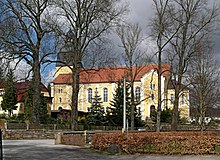
Steinigtwolmsdorf
| coat of arms | Germany map | |
|---|---|---|

|
Coordinates: 51 ° 4 ′ N , 14 ° 21 ′ E |
|
| Basic data | ||
| State : | Saxony | |
| County : | Bautzen | |
| Height : | 394 m above sea level NHN | |
| Area : | 18.03 km 2 | |
| Residents: | 2811 (Dec. 31, 2019) | |
| Population density : | 156 inhabitants per km 2 | |
| Postal code : | 01904 | |
| Area code : | 035951 | |
| License plate : | BZ, BIW, HY, KM | |
| Community key : | 14 6 25 590 | |
| Community structure: | 3 districts | |
| Address of the municipal administration: |
Am Markt 1 01904 Steinigtwolmsdorf |
|
| Website : | ||
| Mayor : | Lutz Förster (Steinigtwolmsdorf Citizens' Movement) | |
| Location of the municipality of Steinigtwolmsdorf in the Bautzen district | ||
Steinigtwolmsdorf ( Upper Sorbian Wołbramecy , Upper Lusatian colloquial Wunsdurf ) is a municipality in the Bautzen district in the southeast of the Free State of Saxony , right on the border with the Czech Republic .
Geography and traffic
Steinigtwolmsdorf is located in the south of the Bautzen district in the middle of the Oberlausitzer Bergland . It is located about 13 km southeast of Bischofswerda and about 14 km southwest of the district town of Bautzen . Steinigtwolmsdorf is on the federal road 98 (Bischofswerda - Oppach - Zittau). The next stop is the Neukirch (Lausitz) Ost stop on the Bautzen – Bad Schandau railway line .
The community is bordered by Wilthen in the north, Schirgiswalde-Kirschau and Sohland an der Spree in the east, Lipová (German Hainspach ) and Lobendava (German Lobendau ) in the south and Neustadt in Saxony and Neukirch / Lausitz in the west.
history
The main town Steinigtwolmsdorf was founded around the year 1250. 1442 was the first mention of "Stenychtem Wolffersdorfe" in written sources. After a small wooden chapel in 1262, the first church was built at the current location in 1363.
The first verifiable feudal owners of the place, the Lords of Hermsdorf, owned Steinigtwolmsdorf from 1340 to 1399.
Around 1459 the landlords of Haugwitz had a sheep farm built on the Birkgut. For the inauguration, linden trees were planted in the yard of the sheep farm. One of them is still standing today and is one of the oldest linden trees in Lusatia. The trunk circumference is over 8 m and the trunk diameter 2.55 m.
Place name
1442 was the first mention of "Stenychtem Wolffersdorfe" in written sources. The original place name was already lost in the 16th century. In 1512 Bishop Johann IV called it "Wuhnsdorf", in 1551 it is mentioned as "Wolmannsdorf". In 1559, “Steinigt Wolframsdorf” and “Steinigtwolfersdorf” are mentioned in a deed. 1594 is the spelling "Steinigt Wuhnsdorf". In 1700 the place name Steinichtwolmsdorf and from 1900 "Steinigtwolmsdorf" was written.
Local division
The districts Ringenhain , Steinigtwolmsdorf and Weifa belong to the community .
Lutz Förster (Citizens' Movement Steinigtwolmsdorf) has been mayor since 2019.
education
The Steinigtwolmsdorf community has a primary school. The town's middle school was closed in 2001.
language
According to the classification of Hans Klecker , the western variant of the Upper Lusatian dialect is spoken in the villages of the municipality . The peculiarity of the so-called abbreviated dialect can mainly be observed in the Weifa district . Unlike in other areas of the Upper Lusatian dialect , prefixes and final syllables are shortened, similar to Bavarian dialect , e.g. B. gwaast instead gewaasen for been .
Attractions
See also: List of cultural monuments in Steinigtwolmsdorf
- Steinigtwolmsdorf Church from 1861
- School museum
- smallest half-timbered house in Upper Lusatia in Ringenhain
- Birkgut linden, approx. 550 years old, trunk circumference 8.15 m
- Weifa village ensemble , the highest place in Upper Lusatia with many half-timbered houses
- Steinigtwolmsdorf water world adventure pool
- Local history museum in Weifa, Kammweg 21
Personalities
- Johann Michael Weiß (1648–1726), theologian, worked for some time as a pastor in Steinigtwolmsdorf
- Christoph Beyer (1653–1741), architect, master builder from Saxony
- Johann George Matthaei (1680–1759), Lutheran clergyman and hymn poet
- Elias Augst (1775–1849), painter, inventor of mechanical puppet theater
- Gustav Hermann Schulze (1833–1901), lawyer, councilor at the Neusalza district court , historian and local researcher of Upper Lusatia
- Helmut Sieber (1908–1977), lawyer and non-fiction author
- Friedrich Wolfgang Porsche (1928–2019), agricultural scientist
- Karlheinz Möbus (1938–2014), GDR diplomat
literature
- Cornelius Gurlitt : Steinigtwolmsdorf. In: Descriptive representation of the older architectural and art monuments of the Kingdom of Saxony. 32nd issue: Bautzen Official Authority (Part II) . CC Meinhold, Dresden 1908, p. 291.
- Gustav Hermann Schulze : Steinigtwolmsdorf (1875)
Individual evidence
- ↑ Population of the Free State of Saxony by municipalities on December 31, 2019 ( help on this ).
- ↑ www.oberlausitzer-woerterbuch.de , dialect areas Oberlausitz
- ↑ https://www.kirche-neukirch.de/kirchgemeinde-steinigtwolmsdorf/kirchengeschichte/index.html , accessed on March 4, 2020
- ↑ List of pastors in Schönigtwolmsdorf since 1550 , accessed on March 4, 2020
- ↑ https://www.steinigtwolmsdorf.de/freibad-wasserwelt.html , accessed on March 4, 2020
Web links
- Steinigtwolmsdorf in the Digital Historical Directory of Saxony
- Detailed information on the history of the Steinigtwolmsdorf Church, the Schuster organ and the church museum , accessed on March 4, 2020


