Lobendava
| Lobendava | ||||
|---|---|---|---|---|
|
||||
| Basic data | ||||
| State : |
|
|||
| Region : | Ústecký kraj | |||
| District : | Děčín | |||
| Area : | 1957.5 ha | |||
| Geographic location : | 51 ° 1 ' N , 14 ° 19' E | |||
| Height: | 344 m nm | |||
| Residents : | 268 (Jan 1, 2019) | |||
| Postal code : | 407 84 | |||
| License plate : | U | |||
| traffic | ||||
| Street: | Dolní Poustevna - Lipová | |||
| structure | ||||
| Status: | local community | |||
| Districts: | 2 | |||
| administration | ||||
| Mayor : | Lenka Hausdorfová (as of 2018) | |||
| Address: | Lobendava 271 407 84 Lobendava |
|||
| Municipality number: | 545708 | |||
| Website : | www.obeclobendava.cz | |||
| Location of Lobendava in the Děčín district | ||||

|
||||
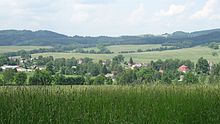
Lobendava (German Lobendau ) is the northernmost municipality in the Czech Republic . It is located five kilometers northeast of Dolní Poustevna in the Schluckenauer Zipfel near the border with Germany and belongs to the Okres Děčín .
geography

Geographical location
The municipality of Lobendava borders in the north and west on Neustadt in Sachsen , in the northeast on Steinigtwolmsdorf , in the east on Lipová u Šluknova (Hainspach) and in the south on Dolní Poustevna (Niedereinsiedel) . The municipality is located south of the Hohwald and extends along the Luční potok (Heimichbach) , into which the Bublava (Zalwasser) flows from the Hohen Hahn .
The Jáchym ( Jochensberg , 472 m ) rises to the northeast , the Ječný vrch ( Gerstenberg , 502 m ) to the southeast and the Raupenberg / Roubený ( 461 m ) to the west on the state border .
Community structure
The municipality Lobendava consists of the districts Lobendava (Lobendau) and Severní (Hilgersdorf) , which also form cadastral districts.
Neighboring communities
The direct neighbors of the main town are the Hohwaldklinik and Severní in the north, Liščí in the northeast, Lipová in the east, Vilémov and Karlín in the south, Markéta and Nová Víska in the southwest and Langburkersdorf in the west.
geology
Geologically and naturally, the Bohemian Netherlands , also known as the Schluckenauer Zipfel , in which the Lobendava municipality is located, belongs to the Lusatian Uplands .
history
Lobendava probably originated in the 12th or 13th century and was first mentioned in documents in 1449.
The old Dresdner Straße, one of the Kaiserstraße to Dresden, ran through the village, and until 1945 there was a customs house on Raupenberg. Lobendau was also on the Böhmischer Steig, which led from Bad Schandau via Sebnitz , Niedereinsiedel , Hilgersdorf and Wilthen to Bautzen .
In 1890 a restaurant was built on the Gerstenberg. In 1930 Lobendau had 1597 inhabitants, in 1939 there were 1587. After the Munich Agreement , the town became part of the German Empire and until 1945 belonged to the Schluckenau district . On May 8, 1945, the 2nd Polish Army under Karol Świerczewski took the place. Today, a large group of Roma lives in Lobendava , the proportion of which is growing compared to the rest of the population. There were repeated conflicts.
Culture and sights
- Baroque Church of the Virgin Mary Visitation, built 1709–1712, rebuilt in 1796 instead of a previous building that had burned down
- Rectory, built in 1767
- Chapel of St. Anne and the Way of the Cross on Anenský vrch , built 1775–1777
- Memorial to those who fell in the wars of 1849, 1859 and 1866 as well as the 66 inhabitants who died in the First World War
- Memorial stone for 19 dead of the 2nd Polish Army
- timbered log houses
- Remains of a chapel and a way of the cross from 1914 on Jáchym
traffic
The state road 267 runs through the village between Dolní Poustevna and Severní, from where the 266 branches off in Lobendava to Rumburk . There are two tourist border crossings Lobendava / Langburkersdorf and Severní / Steinigtwolmsdorf in the municipality .
Personalities
- Hieronymus Opitz the Elder (1519–1591), Lutheran theologian
- Anna Hirsch (1895–1942), communist and resistance fighter against the Nazi regime
- Werner Kirschner (* 1938), politician (SPD), member of the Lower Saxony state parliament
Web links
Individual evidence
- ↑ Obec Lobendava: Podrobné informace. In: Územně identifikační registr ČR. Retrieved March 16, 2014 (Czech).
- ↑ Český statistický úřad - The population of the Czech municipalities as of January 1, 2019 (PDF; 7.4 MiB)
- ↑ Části obcí. In: Územně identifikační registr ČR. Retrieved March 16, 2014 (Czech).
- ↑ Katastrální území. In: Územně identifikační registr ČR. Retrieved March 16, 2014 (Czech).
- ^ Karl-Peter Schwarz: Roma in the Czech Republic: Dispute in the Zipfel , Frankfurter Allgemeine Zeitung, September 1, 2011.

