Ludvíkovice
| Ludvíkovice | ||||
|---|---|---|---|---|
|
||||
| Basic data | ||||
| State : |
|
|||
| Region : | Ústecký kraj | |||
| District : | Děčín | |||
| Area : | 947.9552 ha | |||
| Geographic location : | 50 ° 48 ' N , 14 ° 15' E | |||
| Height: | 320 m nm | |||
| Residents : | 933 (Jan. 1, 2019) | |||
| Postal code : | 407 13 | |||
| License plate : | U | |||
| traffic | ||||
| Street: | Česká Kamenice - Děčín | |||
| structure | ||||
| Status: | local community | |||
| Districts: | 1 | |||
| administration | ||||
| Mayor : | Mgr. Šturma Jiří (as of 2018) | |||
| Address: | Ludvíkovice 71 407 13 Ludvíkovice |
|||
| Municipality number: | 546496 | |||
| Website : | www.ou-ludvikovice.cz | |||
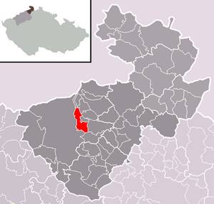
| Location of Ludvíkovice in the Děčín district | ||||

|
||||
Ludvíkovice (German Loosdorf , also Losdorf ) is a municipality in the Czech Republic . It is located four kilometers northeast of the city center of Děčín on the city limits and belongs to the Okres Děčín .
geography
Geographical location
Ludvíkovice extends in the south of Bohemian Switzerland on a plateau on the upper reaches of the Loubský potok ( Laubenbach ). To the north rises the Kamenský vrch ( Hainhübel , 432 m), in the east the Popovičský vrch ( Poppenberg , 527 m), southeast the Sokolí vrch ( Falkenberg , 516 m), in the south the Pustý vrch ( Schichenberg , 499 m), southwest of the Stoličná hora ( cuboid Berg , 289 m) and to the west of the Elbe River Valley falling Růžový hřeben ( Rose comb ) to the Spálenisko (391 m) and the Růžová vyhlidka ( Rose Crest view , 432 m). In the south the village is crossed by the state road I / 13 / E 442 .
Community structure
No districts are shown for the municipality of Ludvíkovice.
Neighboring communities
Neighboring towns are Kámen in the north, Nová Oleška and Stará Oleška in the Northeast, Huntířov and Františkův Vrch in the east, Dobrná the southeast, Folknáře and Libverda in the south, Děčín - Nove Mesto in the southwest, Loubi and Prostřední Žleb the west and Podskalí in the northwest.
history
The Waldhufendorf named after its locator was probably created in the middle of the 13th century when German colonists settled the Scharfenstein rule . Around 1409 the Michalovice lords sold the estate to Hynko Berka from Dubá . His son Hynko II sold the property to the Lords of Wartenberg . Ludwici villa was first mentioned in writing in 1425. The place was the seat of an emperor. Between 1511 and 1515, Nikolaus Trčka von Lípa was the owner of the estate. The next owners were the von Salhausen brothers. In the land register of 1620 20 farmers and seven cottagers are recorded for Loosdorf. In 1770 a chapel was built in the village. In 1816 the Kaiserstraße from Tetschen to Kamnitz was built on the southern outskirts . In 1833 Loosdorf had 533 inhabitants.
After the abolition of patrimonial Loosdorf formed from 1850 with the districts Heidenstein and Falkendorf as well as the Gut Gomplitz a political municipality in the district administration Tetschen / Děčín. In 1869 the village consisted of 114 houses and had 1177 inhabitants. In 1890 there were 1310 people in Loosdorf. At that time Gomplitz was reassigned to Tetschen. The community of Loosdorf had 1,756 inhabitants in 1930. After the Munich Agreement , Loosdorf was added to the German Reich in 1938 and belonged to the Tetschen district until 1945 , and from 1943 Tetschen-Bodenbach . In 1939 there were 1735 people in the community. After the end of the Second World War Loosdorf came back to Czechoslovakia. The German residents were expelled until 1946 and the place was named Ludvíkovice . In 1949 the community Folknáře ( Falkendorf ) was established. In 1980, Ludvíkovice and Kámen were incorporated into Děčín, where the places formed the districts of Děčín XXIX-Ludvíkovice and Děčín XXX-Kámen until the beginning of 1992 and then became independent communities.
Culture and sights
- Monument to Hans Kudlich , erected in 1893 on the initiative of Laurenz Parsche, member of the Loosdorf state parliament
- Wayside shrine, erected in 1824
- Stoličná hora mountain with a view of the Kaiser
- Sokolí vrch mountain with a lookout tower
- Dwarf caves on Pustý vrch
- Arbor bottom
- Růžový hřeben
- Slunečná brána ( Sun Gate ), rock gate at the foot of Kamenský vrch, north of the village


