
Děčín
| Děčín | |||||
|---|---|---|---|---|---|
|
|||||
| Basic data | |||||
| State : |
|
||||
| Historical part of the country : | Bohemia | ||||
| Region : | Ústecký kraj | ||||
| District : | Děčín | ||||
| Area : | 11770.0641 ha | ||||
| Geographic location : | 50 ° 46 ' N , 14 ° 12' E | ||||
| Height: | 135 m nm | ||||
| Residents : | 48,809 (Jan. 1, 2019) | ||||
| Postal code : | 405 02 | ||||
| License plate : | U | ||||
| structure | |||||
| Status: | Statutory city | ||||
| Districts: | 35 | ||||
| administration | |||||
| Lord Mayor : | Jaroslav Hrouda (as of 2018) | ||||
| Address: | Mírové nám. 1175/5 405 38 Děčín 4 |
||||
| Municipality number: | 562335 | ||||
| Website : | www.mmdecin.cz | ||||
| Location of Děčín in the Děčín district | |||||

|
|||||


Děčín ( German Tetschen , 1942–1945 Tetschen-Bodenbach , 1945 Děčín-Podmokly ) is a town in Ústecký kraj on the Elbe in northern Czech Republic , near the border with Saxony . Děčín has the most important rail border crossing between Germany and the Czech Republic, which is part of the trans-European traffic axis North / Baltic Sea - Dresden - Prague. This border crossing was previously known as Bodenbach. Bodenbach (Podmokly) is now the largest district of Děčín on the left Elbe.
Geographical location

The city lies in the transition area between Bohemian Switzerland and Bohemian Central Uplands in a basin into which the Ploučnice (Polzen) flow from the east and the Jílovský potok (Eulaubach and Eulauer Bach) into the Elbe from the west . With an altitude of 135 m nm , Děčín is the deepest town in the Czech Republic. Some of the districts that came to the city through incorporations, such as B. Maxičky (Maxdorf) are already on the heights of Bohemian Switzerland or Bohemian Central Mountains and thus significantly higher.
Neighboring places
| Rosenthal-Bielatal | Gohrisch , Reinhardtsdorf-Schöna | Hřensko (Herrnskretschen) |
| Jílové (Eulau), Malšovice (Malschwitz) |
.svg)
|
Ludvíkovice (Loosdorf) |
| Dobkovice (Topkowitz) | Těchlovice (Tichlowitz), Heřmanov (Hermersdorf) | Dobrná (Hochdobern), Malá Veleň (Klein Wöhlen) |
history
Middle Ages and early modern times


Archaeological finds show that the settlement of the Tetschen valley basin dates back to the younger Bronze Age . In the 10th century, the Přemyslids built a wooden fortification on the site of today's castle. This protected and controlled an important Elbe ford , over which a trade route leading to the Lausitz at the southern foot of the Ore Mountains ran. A trading center was established below the castle and was first mentioned in 993. The Elbe trade itself was mentioned in 1057, the castle for the first time in 1128.
In the 13th century, the wooden fortifications were converted into a stone castle , which also became the administrative center of the Děčín domain. In the second half of the 13th century, King Ottokar II established the town of Děčín, located south of the castle on the Frauenwiese, probably because the older and lower-lying settlement was destroyed by a flood. In the 14th century, the Lords of Wartenberg built a new town in the north of the castle, which accommodated a large part of the inhabitants of the old town. The plague raged here from 1347 to 1350, killing numerous people. For the year 1384 documents prove the city justice and the existence of the guild system (Schusterbrief). The exact time of the city charter is not known. The first half of the 14th century can probably be assumed for this.
In 1534 the lordship of Tetschen together with the town and castle of the same name passed into the possession of the von Bünau . This started a heyday of urban development, as the Bünaus pushed the economic development of their new property. They intensified u. a. the trade in wood, for which the forests in the vicinity of Tetschen offered good conditions. At the same time they introduced sheep breeding and built two large sheep pens in Tetschen. They had orchards and vineyards planted in the vicinity of the city. The increased trade on the Elbe allowed the city to flourish until the Thirty Years War .
During the Thirty Years War , the castle and town were alternately in the hands of Saxon, Swedish and Imperial troops. The city itself burned down several times during this time.
19th and 20th centuries

On the left side of the Elbe there were only a few small, insignificant settlements until the middle of the 19th century, which merged to form Bodenbach in 1850 . One year later, on April 6, 1851, the last section of the Dresden-Bodenbacher railway, leading from Krippen to Bodenbach, was put into operation. The construction of the railway accelerated the development of the left bank of the Elbe, which was economically insignificant up to now. Numerous industrial companies settled here within a few decades. Bodenbach developed into an industrial location with extensive Art Nouveau architecture . Already in 1880 the place surpassed Tetschen on the right bank of the Elbe both in economic importance and in population. It was therefore granted town charter in 1901 . At the beginning of the 20th century, the economic upturn in both cities continued and was reflected in extensive construction activity. Tetschen had two churches, a secondary school, a craft school, a ship's school and was an important industrial location. In 1901 the city theater was built as a variety theater. A synagogue was built in Bodenbach in 1906/07 .
From 1918 Tetschen and Bodenbach belonged to the newly founded Czechoslovakia and, as Elbe ports, had an important function for foreign trade. Through the Munich Agreement in 1938 both cities and the Sudetenland were assigned to the German Reich without the participation of the Czechoslovak government . On October 1, 1942, the cities of Bodenbach and Tetschen were combined with the old town municipality to form the new city of Tetschen-Bodenbach. In 1945, both cities were part of the district of Decin-Bodenbach in the administrative district of Usti nad Labem in the Reich District of Sudetenland . The town's synagogue was one of the few in northern Bohemia to survive World War II.
After the end of World War II , on May 8, 1945, an anti-fascist committee of Germans and Czechs living in the city took over the town hall, and Albert Allert, a German-Bohemian anti - fascist, became mayor. After a few days, Allert was deposed because of his German nationality and replaced by František Eret.
The German-speaking population was from the Sudetenland and Tetschen sold . Their property was confiscated by the Beneš decree 108 , the property of the Protestant church was liquidated by the Beneš decree 131 and the Catholic churches in Czechoslovakia were expropriated .
In 1947 the uniform city name Děčín was introduced. The city's structural development continued in the post-war period. Existing facilities were expanded, and other industrial companies settled there. Many new citizens from Central Bohemia and Moravia, Slovakia, so-called repatriants , and Roma were settled. In the course of urban development, numerous old buildings were demolished, including large parts of the old Tetschen town center. Starting in the 1960s, additional living space was created for the growing population in new and prefabricated districts, mainly on the outskirts.
In 2002, what was then the largest geothermal system in Europe went into operation in the city . The plant generates 78 GWh annually and supplies a large part of the city with geothermal energy. The geothermal water is obtained from a spring at a depth of 400 m. The investments amounted to almost 17 million euros.
Today Děčín is the third largest city in the Ústí region with more than 50,000 inhabitants and at the same time an important economic and administrative center as well as an important transport hub in Northern Bohemia .
Plans for an Elbe barrage Děčín downstream of the city have been advanced since the 1990s . There is environmental resistance to the project, including from neighboring Saxony .
Demographics
In 1749 Tetschen had 210 houses and in 1787 293 houses.
| year | Residents | Remarks |
|---|---|---|
| 1830 | 1,423 | in 291 houses, excluding Bodenbach (190 inhabitants in 34 houses) |
| 1848 | 1,670 | |
| 1857 | 2,783 | on October 31st |
| 1869 | 3,822 | |
| 1880 | 5,612 | |
| 1900 | 9,698 | German residents, (Bodenbach has 10,782 German residents) |
| 1914 | 11,500 | |
| 1930 | 12,855 | of which 9944 Germans (77%), 2,135 Czechs (17%) and 734 foreigners (6%) |
| 1939 | 11,962 | of which 1,362 Evangelicals, 9,702 Catholics, 135 other Christians and seven Jews |
| 1942 | 36,000 | Tetschen-Bodenbach as a whole |
| year | 1947 | 1961 | 1978 | 1991 | 2001 | 2005 |
| Residents | 10,639 1 | approx. 40,000 2 | 49,600 | 55,112 | 52.506 | 51,820 |
City structure
Districts and incorporations
Děčín consists of 35 districts:
- Děčín I - Děčín (Děčín)
- Děčín II - Nové Město (New Town)
- Decin III - Stare Mesto (Old Town ., Former village, not the old town)
- Děčín IV - Podmokly (Bodenbach)
- Děčín V - Rozbělesy ( Rosawitz , incorporated into Bodenbach in 1850)
- Děčín VI - Letná ( autumn meadow , incorporated into Bodenbach in 1850)
- Děčín VII - Chrochvice ( Krochwitz , incorporated in 1849 to Wilsdorf and 1923 to Bodenbach)
- Děčín VIII - Dolní Oldřichov (Niederulgersdorf)
- Děčín IX - Bynov ( Bünauburg , incorporated in 1948)
- Děčín X - Bělá ( Biela , incorporated in 1948)
- Děčín XI - Horní Žleb (upper ground)
- Děčín XII - Vilsnice (Wilsdorf)
- Děčín XIII - Loubí (arbor) with podskalí (rattles)
- Děčín XIV - Dolní Žleb (Lower Ground)
- Děčín XV - Prostřední Žleb (middle distance)
- Děčín XVI - Připeř (Peiperz)
- Děčín XVII - Jalůvčí (Kalmswiese)
- Děčín XVIII - Maxičky (Maxdorf)
- Děčín XIX - Čechy (Czech)
- Děčín XX - Nová Ves (Neudorf)
- Děčín XXI - Horní Oldřichov ( Oberulgersdorf , incorporated into Bodenbach in 1923)
- Děčín XXII - Václavov (Wenceslas Village)
- Děčín XXIII - Popovice ( Pfaffendorf , incorporated into Bodenbach in 1850)
- Děčín XXIV - Krásný Studenec (Schönborn)
- Děčín XXV - Chmelnice ( Hop Garden )
- Děčín XXVI - Bechlejovice (Bachelsdorf)
- Děčín XXVII - Březiny (Birkigt) with Libverda (Liebwerd)
- Děčín XXVIII - Folknáře ( Falcon Village )
- Děčín XXIX - Hoštice nad Labem (Hostitz)
- Děčín XXX - Velká Veleň (Großwehlen , also Großwöhlen)
- Děčín XXXI - Křešice (Krischwitz)
- Děčín XXXII - Boletice nad Labem (Politz ad Elbe)
- Děčín XXXIII - Nebočady (Neschwitz)
- Děčín XXXIV - Chlum (Kolmen)
- Děčín XXXV - Lesná (Hortau)
The 70 basic development units are Bechlejovice, Béla, Boletice nad Labem, Březiny, Bynov, Čechy, Cerveny vrch (Rotberg) , Děčínská výšina (Kaiser view) , decyne-sever, Dolni Oldřichov, Dolni Žleb, Folknáře, Havraní vrch (Rabenstein) , Nádraží , Horní Oldřichov, Horni Žleb, Hoštice nad Labem, Chlum, Chlumská stráň, Chmelnice, Khmelnik (hop Berg) , Chrochvice, Jakuby (Jakuben) , Jalůvčí, Kamenická (Steinbach) , Krásný Studenec, Kristin Hrádek (Christianaburg) , Křešice, Labská niva , Lesná, Lesní Mlýn (Buschmühlenteich) , Letná, Letná Lovosická, Loubi, Marjanín (Mariannaberg) , Maxičky, Nad Boleticemi, Nad Dolním Žlebem, Nad Křešicemi, Nad Slovankou, Nebočady, Nemocnice, Nova Ves, Pastýřská stěna (Schäfer wall) , Pod Chlumem, Podmokly, Popovice, Prostřední Žleb, Průmyslový obvod Boletice, Průmyslový obvod Křešice, Přípeř, Přípeřské polesí (Peiperzer forest houses) , Přístav, Rozbělesy, Upnali, Uocučnice, Uocuón, Uocuón, Uocuón, Uocuón, Uoc , U zimního stadi ónu, Václavov, Velká Veleň, Vilsnice, Východní nádraží, Za nádražím, Zámek (Tetschen Castle) , Želenice (Seldnitz) and Žlíbek (Evil Bundle) .
The settlements of Čertova Voda (Tschirte) , Dolní Chlum (Stabigt) , Libverda (Liebwerd) and Podskalí (Rasseln) also belong to Děčín .
Cadastre
The urban area covers an area of 11,770 hectares and is divided into 22 cadastral districts
- Bělá u Děčína: 564 ha
- Boletice nad Labem: 256 ha
- Březiny u Děčína: 434 ha
- Bynov: 1503 hectares
- Chlum u Děčína: 344 ha
- Chrochvice: 146 ha
- Děčín: 460 ha
- Děčín-Staré Město: 297 ha
- Dolní Žleb: 1091 ha
- Folknáře: 245 ha
- Horní Oldřichov: 143 ha
- Hoštice nad Labem: 256 ha
- Krásný Studenec: 592 ha
- Křešice u Děčína: 393 ha
- Lesná u Děčína: 346 ha
- Loubí u Děčína: 47 ha
- Maxičky: 1854 ha
- Nebočady: 276 ha
- Podmokly: 688 ha
- Prostřední Žleb: 1103 ha
- Velká Veleň: 397 ha
- Vilsnice: 3345 ha
Town twinning
-
 Bełchatów ( Poland )
 -
 Jonava ( Lithuania )
 -
 Pirna ( Saxony )
 -
 Přerov (Czech Republic)
 -
 Ružomberok ( Slovakia )
Culture and sights
Museums
Buildings
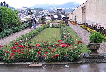
Rose garden by the castle
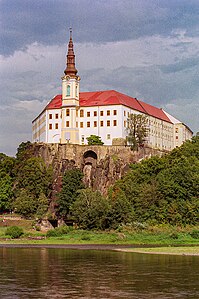
lock

Holy Cross Church


- Děčín Castle : The castle dates back to afortification builtby the Přemyslids at the end of the 10th century(mentioned in 1128) to control navigation on the Elbe. In the 13th century, the wooden structure was converted into a stone castle and expanded. The Bünaus converted the complex into a renaissance castle in the 16th century, but sold it to thevon Thun and Hohenstein familyafter the Thirty Years' War . They used the castle until they moved to Jílové (Eulau) in 1932 and then sold it to the state. Czech border troops have been using the property as barracks since 1934, during the Second World War they were German troops, after the end of the war the Czech army moved in again and after the Prague Spring the Soviet army moved into it. The structure of the building was badly damaged by military use. After the troops withdrew (1991), extensive renovation measures could already be carried out in recent years. Parts of the castle can already be visited again.
- Rose garden (Růžová zahrada) : The garden, laid out in 1670, is located next to the castle, but roses have only been grown here since 1881. The park serves as a venue for concerts in summer.
- Holy Cross Church (kostel svatého Kříže) : The church was built in a phase of the palace renovation from 1687 to 91 as a baroque hall church in place of an old wooden church. It represents one of the most important architectural monuments in northern Bohemia and is decorated with frescoes by Josef Kramolín and a marble altar.
- Johanniskapelle (Thunovská kaple sv. Jana Nepomuckého) : Originally built in 1732 by the von Thuns, the Baroque chapel was built in 1870–1872 according to plans by Friedrich von Schmidt and served as a family grave until 1935. Today the chapel houses a 20-part baroque group of figures.
- Church of St. Wenceslas and St. Blaise (kostel sv. Václava a sv. Blažeje) : The origins of the church probably go back to the 15th century. After the Swedish arson (1642) it was redesigned in the Baroque style, but burned down completely in 1749. The new building, erected by 1778, remained unused until 1826 and then served as a warehouse for a shipping company until 1873. It was not rededicated as a church until 1878.
- Děčín Synagogue : The synagogue was built from 1906 to 1907 in Art Nouveau style combined with Moorish structures.
- Schäferwand : Opposite the castle, the striking 100 m high sandstone cliff rises above the Elbe. On the Schäferwand there is an excursion restaurant and the zoological garden (Zoologicka zahrada).
- Polzenbrücke : Over the river Ploučnice (Polzen) performs a built 1564-1567 Late Gothic stone bridge as a little sister for their baroque sculpture (1714) Prague Charles Bridge applies.
- Elbe bridges : There are several Elbe bridges in the Děčín traffic junction. The cities of Tetschen and Bodenbach had been linked by the Kaiserin Elisabeth Bridge , one of the most beautiful and largest bridges in Bohemia, since 1855 . This chain bridge burned down in 1915. The Tyrš Bridge (Tyršův most), named after Miroslav Tyrš , the founder of a Sokol movement, was built on its pillars in 1933 . In 1867 the first railway bridge was built as a truss bridge over the Elbe.
- Hungerstein : Below the Chain Bridge on the left bank of the Elbe there is an approximately 6 square meter basalt stone in the river, which is only visible at low tide. It is known as a hunger stone because its appearance came along with the cessation of navigation on the river and both boatmen and farmers used to suffer great hardship due to the drought. The lowest water levels have been marked on the stone since 1417, the information since 1616 is still clearly visible. The stone bears the inscription "When you see me, then cry".
- Bohemian Switzerland : Děčín lies on the edge of the hiking and excursion area of the Bohemian Switzerland.
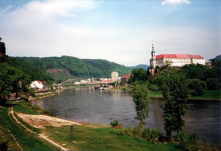
View from the railway bridge to Schäferwand and the castle

View of the Schäferwand - on the left bank of the Elbe

Historical photo of the Hungerstein in the Elbe


Green spaces and recreation
Sports
Economy and Infrastructure
Industry
This city has developed into a 140 km² industrial and administrative city in the north of Bohemia .
traffic

Due to its location on the navigable Elbe with the northernmost inland ports in the Czech Republic (Rozbělesy, Louby) and at one of the most important rail border crossings in the republic, the city has traditionally played an important role in transport, even if inland waterway traffic has declined since the transformation of the 1990s.
The city has two road bridges over the Elbe , the historic Tyrš Bridge (Tyršův most) (built 1933) and the four-lane road bridge ( Nový most ) on the I / 13 (built 1979–1984, renewed 2003–2005), and two railway bridges.
High-ranking rail connections exist with the left Elbe railway line Praha – Děčín (since 1851) and the right Elbe railway line Kolín – Děčín (since 1874, especially freight traffic) and the north adjoining railway line Děčín – Dresden-Neustadt since 1851 in north-south direction, which is part today of the Trans-European Transport Network. In a west-east direction, the branch lines Děčín – Chomutov and Děčín – Jedlová have been connected to the former Bohemian Northern Railway since 1869 at the main train station on the left bank of the Elbe (formerly Bodenbach station) . The place has a marshalling yard on both sides of the Elbe.
The city is through the trunk roads I / 13 (Teplice - Nový Bor) with connection to the motorway D8 (Dresden - Praha) and the I / 62 leading in the Elbe valley (state border near Schmilka - Ústí nad Labem), both parts of the European route 442 , tied up. In 1938 the Elbuferstraße on the right bank of the Elbe to Bad Schandau (now I / 62) was built. Until then, road traffic passed through the Kalmswiese and Schneeberg districts in the hinterland on the left Elbe . The former main road is still preserved today as a paved forest path.
coat of arms
- Tetschen
In the coat of arms of the former royal city of Tetschen there is a two-tailed crowned Bohemian lion holding a barbel . Until 1945 Tetschen used the color white or silver on a blue background, since then the color silver on a red background, the oldest colors of the royal city. The color combination blue and silver was probably introduced after 1628 by the Hohenstein-Thun family , the new rulers, based on their house colors.

- Bodenbach
After the elevation to the city of 1901, Bodenbach got a horizontal three-part coat of arms in 1903: In the upper third on the left side a red gear wheel on a golden background (symbolic for the industry in the village) and on the right side a red anchor wrapped with a rope, shown with a wide golden stripe running diagonally from top left to bottom right on a red background (symbolic for shipping on the Elbe), in the middle third a golden impeller on a red background (symbolic of the railway) and in the lower third a silver wavy line on a green background (symbolic for the Elbe). After the unification of Bodenbach with Tetschen to Tetschen-Bodenbach in 1942, the Bodenbach coat of arms was given up by a resolution of the city council in 1943. The Bodenbach city colors were red and gold.
Personalities
literature
- Anton Emanuel von Komers : Agricultural notes for the visit from Tetschen and Peruc . Prague 1856 ( e-copy ).
- Anton Emanuel von Komers: reflections on the agricultural teaching question; and the agricultural training institute in Tetschen-Liebwerd with sketches from the administration of goods in Bohemia . Prague 1856 ( e-copy ).
- Illustrated Chronicle of Bohemia (published by the Association of Patriotic Scholars and Artists). Volume 1, Prague 1852, pp. 44-48 , pp. 114-118 and pp. 174-177.
- Alena Sellnerová, Jan Hanzlík, Marta Pavlíková: Architektura Podmokel 1900–1945 (architecture by Bodenbach 1900–1945). NPÚ, ÚOP, Ústí nad Labem 2014 (107 pages).
Web links
- Tourist portal of the city of Děčín (Czech, English, German)
- Information on the development of Tetschen and Bodenbach ( Memento from March 27, 2009 in the Internet Archive )
Individual evidence
- ↑ http://www.uir.cz/obec/562335/Decin
- ↑ Český statistický úřad - The population of the Czech municipalities as of January 1, 2019 (PDF; 7.4 MiB)
- ↑ a b Meyer's Large Conversation Lexicon . 6th edition, Volume 19, Leipzig / Vienna 1909, p. 442.
- ^ Kilian Kirchgessner: The miracle of Decin. In: Jüdische Allgemeine, January 11, 2007; accessed on July 28, 2017.
- ↑ Petr Joza in: Czech and German anti-fascists in Děčín after the end of the war. http://www.radio.cz/de/artikel/91103
- ↑ Johann Gottfried Sommer : The Kingdom of Bohemia . Volume 1: Leitmeritzer Kreis , Prague 1833, pp. 234–236, item 1.
- ↑ Yearbooks of the Bohemian Museum of Natural and Regional Studies, History, Art and Literature . Volume 2, Prague 1831, p. 197, paragraph 16 below.
- ↑ Johann Gottfried Sommer : The Kingdom of Bohemia . Volume 1: Leitmeritzer Kreis , Prague 1833, p. 239, item 53.
- ↑ Statistical overviews of the population and livestock in Austria . Vienna 1859, p. 41, right column .
- ^ Meyer's Large Conversational Lexicon . 6th edition, Volume 3, Leipzig / Vienna 1905, p. 121 .
- ^ Rudolf Hemmerle : Sudetenland Lexikon, Volume 4. Adam Kraft Verlag, 1985, ISBN 3-8083-1163-0 , p. 441.
- ^ A b Michael Rademacher: German administrative history from the unification of the empire in 1871 to the reunification in 1990. Tetschen district (Czech: Decín). (Online material for the dissertation, Osnabrück 2006).
- ↑ http://www.uir.cz/casti-obce-obec/562335/Obec-Decin
- ↑ http://www.uir.cz/zsj-obec/562335/Obec-Decin
- ↑ http://www.uir.cz/katastralni-uzemi-obec/562335/Obec-Decin
- ^ District town of Tetschen-Bodenbach (today: Decin). Retrieved July 26, 2020 .