
Rosenthal-Bielatal
| coat of arms | Germany map | |
|---|---|---|

|
Coordinates: 50 ° 52 ' N , 14 ° 3' E |
|
| Basic data | ||
| State : | Saxony | |
| County : | Saxon Switzerland-Eastern Ore Mountains | |
| Management Community : | Koenigstein / Saxon. Schw. | |
| Height : | 408 m above sea level NHN | |
| Area : | 46.61 km 2 | |
| Residents: | 1586 (Dec. 31, 2019) | |
| Population density : | 34 inhabitants per km 2 | |
| Postal code : | 01824 | |
| Area code : | 035033 | |
| License plate : | PIR, DW, FTL, SEB | |
| Community key : | 14 6 28 340 | |
| Community structure: | 3 districts | |
| Address of the municipal administration: |
Schulstrasse 1 01824 Rosenthal-Bielatal |
|
| Website : | ||
| Mayor : | Gebhard Moritz ( CDU ) | |
| Location of the community Rosenthal-Bielatal in the district of Saxon Switzerland-Eastern Ore Mountains | ||
  |
||


Rosenthal-Bielatal is a municipality in the district of Saxon Switzerland-Eastern Ore Mountains in southern Saxony on the border with the Czech Republic . It belongs to the administrative community of Königstein / Sächs. Schw.

geography
Geographical location
The municipality of Rosenthal-Bielatal is located in Saxon Switzerland on the left bank of the Elbe , more precisely in the Bielatal , which extends from Ostrov in the Czech Republic to Königstein . The Lampertsstein rises to the east of the community . The highest point of the municipality is at 533 m in Glasergrund, near the Czech border . The place is surrounded by an extensive forest area. The lowest point is at the confluence of the Cunnersdorfer Bach in the Biela at 160 m.
_(01-2).jpg)
Community structure and incorporations
Today's Rosenthal-Bielatal community was formed through the gradual amalgamation of nine villages and iron hammers and hammer goods.
Bielatal was created in 1933 through the merger of the village of Hermsdorf with the Reichstein and Brausenstein settlements , both of which emerged from two hammer mills. The small settlement of Raum was incorporated into Bielatal on July 1, 1948.
Rosenthal was created through the merger of the village of the same name with the former iron hammers Neidberg , Oberhütten , Ottomühle and the sanatorium Schweizermühle .
The unification of Bielatal and Rosenthal took place on January 1st, 1994. Today's community consists of the three districts Bielatal, Rosenthal and Raum .
Neighboring communities
The municipality of Rosenthal-Bielatal borders the municipality of Gohrisch in the east, the town of Königstein in the north and the town of Bad Gottleuba-Berggießhübel in the west .
history
Rosenthal was first mentioned in 1356. Until 1503 it belonged to Bohemia , then to Saxony . The hamlet of Hermsdorf has been known since 1410, while the Reichstein settlement emerged from an iron hammer east of the Biela (" hammer to Reichensteyn an der Bile bey Pirne "), first mentioned in 1492 . The hammer mill produced scythes, plowshares and "Gezeug" until 1733. The community experienced an upswing at the beginning of the 19th century with the establishment of the cold water sanatorium Schweizermühle , which was also frequented by members of the European nobility . The Rosenthal Volunteer Fire Brigade was founded in 1879 . The cold water facility was closed in 1912 and used by the Maggi company as a rest home for its employees. During the GDR era, the buildings were used as a sanatorium for tuberculosis sufferers and as an old people's home. There has been a carnival club in Bielatal since 1958. Every year since 1992, around 20 children from the areas around Brahin , affected by the Chernobyl nuclear disaster, have come in January to recover in Rosenthal.
In 2012 the municipal council presented a contract for incorporation into the city of Königstein. The majority of the 2013 referendum voted against the incorporation.
Population development
| Population development in the community of Rosenthal-Bielatal | |||||||||||||||
|---|---|---|---|---|---|---|---|---|---|---|---|---|---|---|---|
| year | 1994 | 1995 | 1996 | 1997 | 1998 | 1999 | 2000 | 2001 | 2002 | 2003 | 2004 | 2005 | 2006 | 2007 | 2008 |
| Residents | 1825 | 1853 | 1888 | 1889 | 1871 | 1850 | 1873 | 1830 | 1816 | 1819 | 1799 | 1751 | 1714 | 1703 | 1696 |
| year | 2009 | 2010 | 2011 | 2012 | 2013 | 2014 | 2015 | 2016 | 2017 | 2018 | 2019 | ||||
| Residents | 1689 | 1680 | 1723 | 1704 | 1677 | 1664 | 1667 | 1634 | 1608 | 1592 | 1586 | ||||
Culture and sights
- Climbing area Bielatal : With 239 peaks and over 3,400 climbing trails of all levels of difficulty, the Bielatal is one of the most diverse and popular climbing areas in Saxon Switzerland.
- Brausenstein blast furnace , as a contemporary witness of the metallurgical industry in the Bielatal and cultural monument
- Hercules Columns, Leaning Tower, Pulpit Tower, Daxenturm, Grandfather's Chair, Spannagelturm, Abandoned Wall, Border Plate, Abandoned Forester, Forest Needle, Bielazinne, Eagle Stone, Forest Guard, Glaser Base Tower, Wiesensteine, Johanniswacht, Sachsenstein and other rocks in the Bielatal.
- Ice caves, Schwedenhöhle and Bennohöhle above the Otto mill, they are among the deepest caves in the Free State.
- Panorama height (426 m above sea level) in the northwest of Hermsdorf, with a distant view of Saxon Switzerland .
- Bielatal hunting lodge
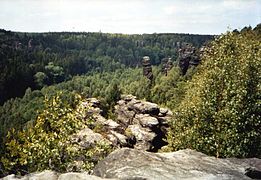
View of the Bielatal

View of the historic blast furnace
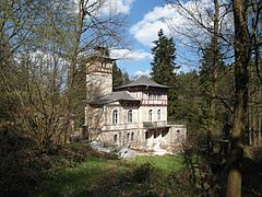
Bielatal hunting lodge


politics
Since the local elections on May 26, 2019 , the municipal council has consisted of 14 seats, which are distributed as follows:
Economy and Infrastructure
traffic
At the beginning of the 20th century, the upper Bielatal was also to be connected by the Bielatalbahn , which opened in 1901, but the planned extension to Schweizermühle did not come about for financial reasons. In September 1904 the line was closed again.
In the local public transport Rosenthal-Bielatal is served by the lines 242 (Königstein - Rosenthal), 245 (Pirna - Rosenthal) and 247 (Berggießhübel - Bad Gottleuba - Rosenthal) of the regional traffic Saxon Switzerland-Eastern Ore Mountains (RVSOE). Line 247 is only used for school traffic, while lines 242 and 245 also run on weekends and are mainly used by day trippers. A trailer for bicycle transport is carried on lines 242 and 245 on weekends in the summer, and both lines are run with a few trips on the road that is closed to other motorized traffic as far as the Czech border to Tyssa and Peterswald .
Until 1938, the main connection between Pirna and Bodenbach , today's federal highway 172 , ran via Hermsdorf and Rosenthal. After completion of the continuous road connection in the Elbe Valley via Schmilka , the route via Rosenthal lost its importance. The road is only released for hikers and cyclists and, since spring 2016, also cross-border, for RVSOE buses.
education
Until 1990 there was one school each in Rosenthal and Bielatal. With the construction of a new secondary school in Rosenthal in 1990, the two schools were closed. The high school was converted into a primary school in 2004, teaching one class per grade. The primary school has about 80 students and six teachers.
Personalities
- Karl Gottlob Clausnitzer (1714–1788), Lutheran theologian
- Gottfried August Homilius (1714–1785), composer, pianist, cantor and organist
- Friederike de Haas (1944–2019), politician (CDU), member of the Saxon state parliament
- Kersten Lahl (* 1948), Lieutenant General, President of the Federal Academy for Security Policy in Berlin
Partner communities
- Betzweiler forest , Baden-Wuerttemberg
- Eitelborn , Rhineland-Palatinate
- Jílové (German Eulau ), Czech Republic
literature
- In the south of the Barbarine (= values of the German homeland . Volume 3). 1st edition. Akademie Verlag, Berlin 1960.
- Municipality of Rosenthal-Bielatal (ed.): From the history of the municipality of Rosenthal-Bielatal . Rosenthal-Bielatal 2013
- Alfred Meiche : Historical-topographical description of the Pirna administration . Dresden 1927 (ND Sebnitz 1991). ( Digitized version ( memento from July 26, 2011 in the Internet Archive ))
Web links
- Rosenthal-Bielatal in the Digital Historical Directory of Saxony
- Rosenthal in the Digital Historical Directory of Saxony
- Bielatal in the Digital Historical Directory of Saxony
Individual evidence
- ↑ Population of the Free State of Saxony by municipalities on December 31, 2019 ( help on this ).
- ^ Henning Steinführer: The Leipzig Council Books 1466–1500 . Research and Edition (= sources and materials on the history of the city of Leipzig 1), 2 volumes, Leipziger Universitätsverlag, Leipzig 2003, certificate no. 1259 Arbitral settlement of a dispute between Peter Fleischauer and his wife Cristina.
- ^ Project group Children of Chernobyl. Rosenthal-Bielatal municipality, accessed on August 17, 2016 .
- ↑ Municipal council election 2019. State Statistical Office of the Free State of Saxony , accessed on November 22, 2018 .
Altenberg | Bad Gottleuba-Berggießhübel | Bad Schandau | Bahretal | Bannewitz | Dippoldiswalde | Dohma | Dohna | Village grove | Dürrröhrsdorf-Dittersbach | Freital | Glassworks | Gohrisch | Hartmannsdorf-Reichenau | Heidenau | Hermsdorf / Erzgeb. | Hohnstein | Klingenberg | Königstein (Saxon Switzerland) | Kreischa | Liebstadt | Wages | Müglitztal | Neustadt in Saxony | Pirna | Rabenau | Rathen | Rathmannsdorf | Reinhardtsdorf-Schöna | Rosenthal-Bielatal | Sebnitz | City of Wehlen | Stumble | Struppen | Tharandt | Wilsdruff