
Dippoldiswalde
| coat of arms | Germany map | |
|---|---|---|

|
Coordinates: 50 ° 54 ' N , 13 ° 40' E |
|
| Basic data | ||
| State : | Saxony | |
| County : | Saxon Switzerland-Eastern Ore Mountains | |
| Height : | 375 m above sea level NHN | |
| Area : | 103.99 km 2 | |
| Residents: | 14,310 (Dec. 31, 2019) | |
| Population density : | 138 inhabitants per km 2 | |
| Postal code : | 01744 | |
| Primaries : | 03504, 035052 | |
| License plate : | PIR, DW, FTL, SEB | |
| Community key : | 14 6 28 060 | |
| LOCODE : | DPW | |
| City structure: | 21 districts | |
City administration address : |
Markt 2 01744 Dippoldiswalde |
|
| Website : | ||
| Lord Mayor : | Kerstin Körner ( CDU ) | |
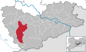
| Location of the town of Dippoldiswalde in the Saxon Switzerland-Eastern Ore Mountains district | ||
  |
||


Dippoldiswalde ([ dɪpɔldɪsˈvaldə ], colloquially Dipps ) is a large district town in the Saxon Switzerland-Eastern Ore Mountains district in Saxony . The city is centrally located in the Eastern Ore Mountains and is about 20 kilometers south of Dresden , halfway between the border with the Czech Republic and the state capital. With around 14,000 inhabitants, Dippoldiswalde is one of the three medium-sized centers in the district .
The first documented mention of Dippoldiswalde dates back to 1218, since then the city has been the administrative center of several historical territories, such as the Dippoldiswalde office in the Middle Ages and later an administrative governing body . Most recently, Dippoldiswalde was the district town of the Weißeritzkreis until 2008 (license plate DW ). Since the district seat was moved to Pirna , Dippoldiswalde has been a major district town. In addition to the core town, the town of Dippoldiswalde now includes twenty districts that were formed from formerly independent communities from the surrounding area.
geography
The city is located in the northern Ore Mountains on the Rote Weißeritz .
City structure
The town consists of the Dippoldiswalde Dippoldiswalde nucleus and twenty hamlets, 1973-2014 incorporated were. All districts form their own district at the same time . The boundaries of districts and districts are usually congruent. In some districts there are several places that then belong to the same district. The core town has the largest share of the population of the city of Dippoldiswalde, followed by Schmiedeberg and Reichstädt , which also have over 1000 inhabitants.
| District | Incorporation | population |
|---|---|---|
| Ammelsdorf | 2014 | 151 |
| Berreuth | 1973 | 162 |
| Dippoldiswalde (core town) | - | 5039 |
| Donschten | 2014 | 185 |
| misery | 1973 | 99 |
| Hennersdorf | 2014 | 453 |
| Malter | 2003 | 729 |
| Naundorf | 2014 | 646 |
| Low mob | 2014 | |
| Obercarsdorf | 2014 | 854 |
| Ugly | 1994 | 329 |
| Upper mob | 2014 | 22nd |
| Paulsdorf with soaps | 2003 | 733 |
| Reichstädt | 1995 | 1353 |
| Reinberg | 1994 | 115 |
| Reinholdshain | 1994 | 534 |
| Sadisdorf | 2014 | 397 |
| Schmiedeberg | 2014 | 1769 |
| Schönfeld | 2014 | 237 |
| Seifersdorf | 2003 | 1015 |
| Ulberndorf | 1973 | 501 |
Status: 2017
history
From the 12th century to the end of the war in 1945

According to legend, Dippoldiswalde goes back to a hermit named Dippold, who is said to have lived in the Dippoldiswalder Heide on the Einsiedlerfelsen around 800 . This is said to have founded the place. The only thing behind this legend is the fact that the locator was an otherwise undetectable person named Diepold. The name of the place is traced back to this personal name, which carries the Old High German word diot (people) and soon (bold) or walt in the sense of rule.
According to many historians, Dippoldiswalde was founded as a Waldhufendorf under the direction of the Burgraves of Dohna around 1160/70. Gerhard Cheap sees a possibility that these burgraves colonized the so-called Burgwartsberg in Pesterwitz before 1206 , built the castles Rabenau and Dippoldiswalde and had villages cleared . Since a German Burgward Dohna is not documented in Gau Nisan and neither is a Burggrafschaft Dohna before 1156, this possibility is unlikely. In view of new dendrological finds in the old mine of Dippoldiswalde from 1160, even the foundation directly from Dohna is questionable. As the latest mining archaeological research shows that Dippoldiswalde is a very early mining settlement, it does not necessarily have to be a Waldhufendorf. This would then be rather unlikely.
The first documentary mention took place on June 11, 1218, when a Johannes sacerdos de Dipoldiswale (Pastor Johannes von Dippoldiswalde) was mentioned in a document of the Meißner bishop . A village church must have already existed there. In 1266, Dippoldiswalde is attested as the property of the Wettin margrave Heinrich the Illustrious , when the citizens of Dippoldiswalde had a dispute with the citizens of Freiberg over deliveries to mines. In the diploma, however, it is not stated where the mines in question were located, so this written source does not constitute evidence of Dippoldiswalder silver mining around 1266.

At that time there were already two representative stone churches in Dippoldiswalde - the Marienkirche, built around 1200 near the market, and the somewhat younger Nikolaikirche in the Weißeritzaue. Only the late Romanesque-early Gothic west tower of the Marienkirche (the Lorenz patronage mentioned in the Middle Ages is not attested) is present. In contrast, the Nikolaikirche, built around 1230/40 as a short basilica without a tower, has been completely preserved. This was built as a new building after the demolition of the original village church, which must have been a smaller hall church made of wood or stone.
As part of renovation and safety work on old mining facilities , backfilled high medieval silver mines were discovered in the area of the Obertore and on Dresdner Straße, which were verifiably in operation in the 12th century. The oldest dated pit timbers come from 1158 and, although used secondarily, from 1170, numerous other timbers from the period from 1183/84. In addition, wooden shaft extensions, turned bowls, remains of rope, ceramic shards and bones from the 13th century were found. The previously discovered shafts were shortly after the mid-13th century again filled Service. A second mining phase, in which the previously backfilled mines were driven through, could be dendrochronologically dated to around 1280. Silver mines in Dippoldiswalde were explicitly mentioned for the first time in 1300, when Friedrich Clem (the illegitimate son of Margrave Heinrich the Illustrious) transferred the silver tithe to the Nimbschen monastery near Grimma .
In 1401, Margrave Wilhelm I occupied Dippoldiswalde in the Dohna feud , which had been lent to the Burgraves of Dohna by the Wettins since 1366. At this time there was still a very small amount of mining at Dippoldiswalde, which no longer produced any income, as can be seen from the mint master's accounts 1401–1405. It was not until the 1470s that mining took off again in the second mining period.
In 1429 invading Hussites destroyed Dippoldiswalde. They also destroyed the three Vorwerke Wolframsdorf (in the middle Schwarzbachtal), Schwarzdorf (in the upper Schwarzbachtal) and Ziegenrück (on the western valley slope between Ulberndorf and Obercarsdorf ), which were not rebuilt afterwards.
In 1541 the Lutheran Reformation reached the place. In 1632 the city suffered severe damage in the Thirty Years' War . As the location of a margrave castle, Dippoldiswalde took on functions as a dominant, administrative and commercial or market center for the surrounding towns at an early stage ( office ). Consequently, in 1874 the city became the seat of the new Dippoldiswalde administration .
At the end of the Second World War , on April 17, 1945, anti-aircraft guns of the Wehrmacht shot down two American planes which crashed near the Teichmühle. On the night of May 9th, a Red Army vanguard raised the victory flag on the church tower.
May 1945 into the 21st century
The first local commandant was Major Datschin. The troops stationed here were responsible for many looting and rape. In accordance with the decision of the Allies and the new state administration, large companies, land and landowners were now expropriated (→ Land Reform Act ).
New, smaller, state- owned companies emerged in the GDR era, including a fittings factory, a container construction company and a foodstuff factory . There was also an engineering school for the food industry and a state-owned estate . Dippoldiswalde became a district town in the district administrative structures of that time. After the reunification , with the reorganization of the federal states, the city remained a district town until 2008, with the second Saxon district reform, Dippoldiswalde lost this status when the Weißeritzkreis was dissolved on August 1, 2008 in the newly created district of Saxon Switzerland-Eastern Ore Mountains.

Development of the population


Development of the population (from 1998 as of December 31st)
| until 1945 | from 1945 |
|
|
For the jump in the number of inhabitants in 2013/2014 see also the section Development of the number of inhabitants in the article Schmiedeberg (Dippoldiswalde) .
politics
City council
The city council was last elected on May 26, 2019. The total of 22 seats are distributed among the individual parties and lists as follows:
- Free voters : 7 members
- CDU : 6 members
- AFD : 5 members
- LEFT : 2 members
- SPD : 1 member
- Greens : 1 member
In the mayoral elections that took place at the same time, Kerstin Körner ( CDU ) was able to prevail against Dirk Massi (non-party) with 75.04% against 24.96%.
Twin cities
Dippoldiswalde maintains partnerships with the Czech Bílina , the Polish Stronie Śląskie (Seitenberg) and with the municipality of Bösel near Oldenburg.
coat of arms

Description: A portrait in gold of a white-bearded hermit with a nimbus and a blue robe with two crossed straps. It is elevated by two diagonally crossed natural three-rooted uprooted conifers with three cones each.
Symbolism: The coat of arms contains a curiosity. The founder Dippold contained in the coat of arms is taken from a legend. This Dippold is said to have lived in the wooded areas of what is now the Dippoldiswalder Heide around the Einsiedlerstein in the Heide. This man appeared in the coat of arms from 1588. In 1669 he then wore a beret and in 1730 he received crossed ribbons on his chest. The crossed trees with the cones are based on the coat of arms of the Burgraves of Dohna (two crossed silver stag poles). The current city coat of arms was created in 1894 with the following content: The hermit is given a blue robe, the city colors blue and yellow were chosen.
Culture and sights
Buildings


- Historic old town center with market square and late Gothic town hall
- Castle : built around 1200 as a margrave castle on a mountain spur, today's appearance since the 16th / 17th. Century, the central building erected from 1530 resembles the Dresden Palace . In addition to the district court, you will also find the Osterzgebirgsgalerie here.
- Stadtkirche St. Marien und Laurentius : Gothic hall church with Romanesque west tower and early Baroque painting
- Romanesque basilica of St. Nikolai from the 13th century in the cemetery
- Malter dam
- Sports park: After the floods in August 2002 destroyed the sports field at the Vorsperre, the new sports park was inaugurated in June 2004. The main user is the FSV Dippoldiswalde .
- Tannery: former residential building from 1756, today a museum
- Medieval wayside shrines ( prayer pillars ) from the Holy Way in front of the church (Kirchplatz), on Niedertorplatz and on Weißeritzstraße / Große Mühlenstraße
- Well room
- Saxon quarter milestone (primitive form) No. 9 of the Obergebirgische Poststraße from 1723 on the Pfortenberg, opposite the former post office (bus station) and a replica of the Saxon postal distance column from 1723 on Obertorplatz (formerly Obertor), which was removed at the end of the 19th century
- Reichstädt Palace in the Reichstädt district, temporarily owned by the last Saxon postmaster general Adam Rudolph von Schönberg (bust in the courtyard)

Dippoldiswalde Castle
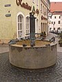
Schuhbrunnen in Schuhgasse

Main portal of the city church
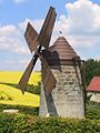
Holländermühle in Dippoldiswalde, district of Reichstädt

Wayside shrine on the church square
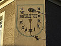
Sundial in the Brauhausgasse


Memorials

- Commemorative plaque in the city park near the Parksäle / Dr.-Friedrichs-Straße bus stop in memory of the local Nazi opponents, including the communist city councilor Clemens Holzschuh , who, according to GDR historiography , was murdered in March 1933 as the first victim of the Nazi dictatorship in the city prison . A memorial plaque also commemorates him on the residential building at Herrengasse 14. The latest research results doubt a murder: “In Dippoldiswalde it was the prison death of the local KPD functionary Clemens Holzschuh, who was instrumentalized after the Second World War to stylize another dictatorship. In the GDR, the anti-democrat Holzschuh, who had a previous conviction for various violent and explosive offenses, was declared an anti-fascist martyr. To this end, a murder thesis was constructed after 1945, which the new political leaders should serve as an anti-fascist or moral basis for legitimation. This thesis lasted well into the turning point. In 2005 the city chronicle took over sources that do not exist in the city museum [...] In fact, no evidence of a murder can be found. "
- Memorial stone on Obertorplatz at the corner of Brauhofstrasse / Herrengasse in memory of the Wehrmacht soldier Johannes Rockstroh from Venusberg , who was hanged by SS men on May 8, 1945 for conscientious objection to military service .
- Grave site and memorial plaque in the cemetery of the Hennersdorf district for three unknown concentration camp prisoners who were murdered by SS men during the death march from one of the subcamps of the Flossenbürg or Buchenwald concentration camps
- The grave and memorial stone in the cemetery in the Sadisdorf district commemorate 26 concentration camp prisoners who were shot in the neck by SS men on a death march from one of the satellite camps on Sadisdorf Herrenweg
- Tartar grave for Mustapha Sulkowicz (killed on July 1, 1762 near Reichstädt), he served with the Polish-Tatar Uhlans under the Saxon Colonel Adam Burkhardt Christoph von Schiebel (also Schiebell) (1719–1779), old picture .
Museums
There are three museums in Dippoldiswalde:
- The tannery, city and district museum , housed in a tannery built around 1750, provides information in 22 exhibition rooms about the tannery trade, the town's history and the regional history of the Eastern Ore Mountains. The most popular special exhibition is the annual Christmas exhibition from November to February, which shows Eastern Ore Mountains folk art and many mechanically operated models in 15 exhibition rooms.
- The Osterzgebirgsgalerie museum in Dippoldiswalde Castle presents around 300 works of fine art on the subject of “People and Landscape in the Osterzgebirge” in the six oldest rooms.
- In autumn 2018 the “ Museum for Medieval Mining in the Ore Mountains ” opened in Dippoldiswalde Castle .
Regular events
- In addition to church services, concerts are also regularly held in the town church.
- In the Park Halls Dippoldiswalde cultural center , along with other events, Saxony's oldest series of master interpreters has been held since 1978.
- In the town hall, the Musikverein Dippoldiswalde e. V. since 2000 with the cultural center word and music literary-musical programs.
- The Musikverein has been organizing the annual International Belcanto Master Course Dippoldiswalde since 2003, which is unique of its kind, at least for Central Germany (currently suspended).
- City festival in Dippoldiswalde usually on the first weekend in June
- Christmas market in Dippoldiswalde (two weeks in December)
- historical Christmas market in the courtyard of the Dippoldiswalder Castle and around the town church
- Major event Malter in flames at the Malter dam (always in July)
- Small train festival along the route of the Weißeritztalbahn with a large station festival in Dippoldiswalde and other events at the Seifersdorf and Malter stations
- Autumn ball of the Lions Club Dippoldiswalde e. V. in the park halls
- Musical from the "Glückauf" high school in Dippoldiswalde / Altenberg
- Kleinkunstbühne Dippoldiswalde organized by the musicians' club
Economy and Infrastructure
economy
Dippoldiswalde is the first city in Saxony and in the new federal states to meet the criteria of a prime shopping city. The certificate was handed over on June 10, 2008.
traffic
railroad

Dippoldiswalde has been connected to the railway network since 1882. This year, in 750 mm was narrow gauge executed Weißeritztalbahn after Schmiedeberg opened a year later the extension followed up Kipsdorf. Since the devastating flood of the century in 2002 , the Weißeritztalbahn was closed. Reconstruction began in 2007; the section between Freital-Hainsberg and Dippoldiswalde has been in operation again since December 14, 2008, and since June 17, 2017, to the Kipsdorf health resort.
Road traffic
Dippoldiswalde is located on the important federal highway 170 between Dresden and the Czech border near Zinnwald. The heavily frequented transit route led directly through the city center. In 1977 work began on building a bridge to bypass the city center, but this was soon interrupted and only completed between 1993 and 1995. Since then, the B 170 has passed the city center to the east. Despite the construction of the A 17 , the road is still very busy, and truck traffic has repeatedly caused protests from residents. However, since the end of 2006 the B 170 has been closed to heavy truck traffic.
Public transport
The bus station in Dippoldiswalde is served by various bus routes of the regional Saxon Switzerland-Eastern Ore Mountains. The main lines are:
- 348 Dippoldiswalde - Oelsa - Rabenau - Freital - Wilsdruff
- 360 Dresden - Bannewitz - Dippoldiswalde - Altenberg - Zinnwald
- 370 Dippoldiswalde - Falkenhain - Altenberg
- 376 Dippoldiswalde - Seifersdorf - Rabenau - Freital
- 382 Dippoldiswalde - Ruppendorf - Tharandt
- 388 Dippoldiswalde - Niederfrauendorf - Glashütte
- 398 Dresden - Dippoldiswalde - Zinnwald - Teplice
In addition, there is a city traffic line with line 361 between the Dippoldiswalde Nord development area and the Ulberndorf district.
Authorities
- A citizens' office and some departments of the district office of the Saxon Switzerland-Eastern Ore Mountains are located in Dippoldiswalde.
- The Dippoldiswalde District Court is located in Dippoldiswalde Castle .
- A local association of the Federal Agency for Technical Relief (THW) has been in Dippoldiswalde since 2005 .
media
- The local editorial office of the Sächsische Zeitung based in Dippoldiswalde produces a local edition every working day.
- Since January 1st, 2014 the "Dippolds Bote" has been the official journal of Dippoldiswalde.
- The regional TV program FRM-TV produces a weekly regional magazine and other articles on local events.
- The "Reichstädter Nachrichten" appears monthly as a magazine of the local council.
schools
The miller's school, founded in 1881, has had its headquarters in Dippoldiswalde since 1888.
Further story:
- 1938: Higher technical college for milling and milling
- 1949: New establishment of the German Milling School in Braunschweig
- 1958: Conversion of the milling school into the technical college for milling in Dippoldiswalde
- 1962–1990: Engineering school for the food industry in Dippoldiswalde
- now: Vocational School Center (BSZ) Freital-Dippoldiswalde
In addition to the vocational school center, there are the following school facilities in the municipality of Dippoldiswalde:
- Reichstädt primary school
- Seifersdorf primary school
- Schmiedeberg primary school
- Oberschule am Pfortenberg , Dippoldiswalde
- Schmiedeberg High School
- Special school (L) Dippoldiswalde, Reinholdshain district
- "Glückauf" -Gymnasium Dippoldiswalde / Altenberg , main location Dippoldiswalde
- Volkshochschule Weißeritzkreis, Dippoldiswalde
- Dippoldiswalde art and music school
- Dippser Harmonica Music School
- Study group Dippoldiswalde
Personalities
Others
dialect
In Dippoldiswalde, a form of the Saxon dialect is spoken: the southeast Meissen niche , which is one of the five Meissen dialects .
Disasters and calamities
- September 6, 1633: The city was set on fire by the troops of Field Marshal Heinrich von Holk . With the exception of the castle, the Nicolaikirche and a few houses, almost the entire development fell victim to the flames, and there were numerous victims among the population.
- October 7, 1634: Dippoldiswalde was set on fire again by marauding troops. 150 houses were destroyed.
- March 14, 1826: A city fire destroyed large parts of the city center. A total of 102 front and 100 side buildings and 12 barns burned down
- August 2002: flood of the century
literature
- IG Grundig / JF Klotzsch: On the age of the city of Dippoldiswalde. In: Collection of mixed news on Saxon history. Zweyter Volume, Chemnitz 1768, 1-80.
- Christiane Hemker / Yves Hoffmann: A high medieval mining area in Dippoldiswalde. In: Excavations in Saxony, 1st year, 2009, pp. 104-109.
- Yves Hoffmann: The history of Dippoldiswalde up to the end of the first mining period around 1400. In: Work and research reports on Saxon soil monument preservation 51/52, 2009/2010 (2011), p. 391–421 ( digitized version ; PDF; 2.1 MB ).
- Konrad Knebel , History of the city of Dippoldiswalde up to 1918. Dippoldiswalde 1920.
- H. Löscher : The Erzgebirge mining law of the 15th and 16th centuries. II / 1. Part: Erzgebirge mountain regulations, mountain freedoms and other documents relating to mining law and mining from the 15th century. Document book 1, 1400–1480 (newly compiled from the estate and edited by Erika Löscher). Freiberg 2003 (Freiberg Research Books D 213)
- Michael: The churches in Dippoldiswalde. Berlin undated [1939] (= German Evangelical Churches A 5/6).
- CE Rüger, contributions to the older history of the city of Dippoldiswalde. Dippoldiswalde 1863.
- Saxony's church gallery. Fourth volume. Fifth Division. The inspections: Pirna, Altenberg and Dippoldiswalde. Dresden undated [around 1840].
- Urban settlements in the eastern Ore Mountains. In: Eastern Ore Mountains (= values of the German homeland . Volume 10). 1st edition. Akademie Verlag, Berlin 1966, pp. 244-257.
- Richard Steche : Dippoldiswalde. In: Descriptive representation of the older architectural and art monuments of the Kingdom of Saxony. 2. Issue: Amtshauptmannschaft Dippoldiswalde . CC Meinhold, Dresden 1883, p. 11.
- Dippoldiswalde . In: August Schumann : Complete State, Post and Newspaper Lexicon of Saxony. 1st volume. Schumann, Zwickau 1814, pp. 685-692.
Web links
- Spiegel: By chance, archaeologists came across silver mines from the 12th century in Dippoldiswalde, Saxony , February 8, 2012
- Official Dippold's Messenger
- https://wahlen.sachsen.de/Erresult_GR19.php?landkreis=14628&gemeinde=14628060&_ptabs=%7B%22%23tab-sitzverkauf%22%3A1%7D
Footnotes
- ↑ Population decline in the Thirty Years War
- ↑ Increase in population due to the reception of war refugees
- ↑ As of October 3rd
- ↑ Already takes into account the incorporation of Malter on January 1, 2003
Individual evidence
- ↑ Population of the Free State of Saxony by municipalities on December 31, 2019 ( help on this ).
- ^ City of Dippoldiswalde: Facts and Figures - Population figures for Dippoldiswalde and districts , accessed on April 18, 2018
- ^ Ernst Eichler and Hans Walther : Saxony. All city names and their history , Faber and Faber Verlag, Leipzig 2007, ISBN 978-3-86730-038-4 , p. 52f.
- ^ Gerhard Billig: The Burgward organization in the Upper Saxon-Meissnian area. Archaeological-archival comparative studies (= publications of the State Museum for Prehistory Dresden. Vol. 20). Deutscher Verlag der Wissenschaften, Berlin (East) 1989, ISBN 3-326-00489-3 , p. 74.
- ↑ Forgotten Underworld: Is Mining Older Than You Think ? In: Freie Presse from March 19, 2018.
- ↑ a b c Hoffmann 2011 - see list of literature
- ^ Dippoldiswalde in the Digital Historical Directory of Saxony
- ↑ Dipps Freiberg overtakes the rank? , Sächsische Zeitung (local edition Pirna) of October 23, 2012.
- ↑ Dipps is at least as old as Freiberg , Sächsische Zeitung (local edition Dippoldiswalde) from February 2, 2011.
- ↑ Sensational find in Dipps: Mining is much older , Sächsische Zeitung (local edition Dippoldiswalde) of May 29, 2009.
- ^ Mining sensation in Dippoldiswalde , Sächsische Zeitung (local edition Dresden-Neustadt) of October 21, 2009.
- ↑ Eckart Granitza: The underworld of the Middle Ages. The more than 800-year-old mines discovered in Dippoldiswalde in Saxony give an impression of the arduous work underground. In: Frankfurter Rundschau of December 24, 2015, pp. 30–31
- ↑ a b Meyer's New Lexicon in eight volumes. VEB Bibliographisches Institut Leipzig, 1964/65; Volume 2: Dippoldiswalde.
- ↑ Summary of the results of the city council election ( page no longer available , search in web archives ) Info: The link was automatically marked as defective. Please check the link according to the instructions and then remove this notice. . Website of the city of Dippoldiswalde, accessed on May 17, 2017.
- ↑ Summary of the results of the mayoral election website of the city of Dippoldiswalde, accessed on August 28, 2019.
- ↑ Sportpark Dippoldiswalde. FSV Dippoldiswalde, accessed on May 16, 2017 .
- ↑ Martin Hundeck: The seizure of power in the Saxon province using the case study of the small town of Dippoldiswalde . Pp. 116-117.
- ↑ Dippoldiswalder Bote No. 21 (2007) (accessed December 5, 2015)
- ^ Website of the Lohgerber Museum , accessed on October 25, 2019
- ^ Museum website
- ↑ Bundesstraße B 170 closed to trucks from December 21, 2006 , citizens' initiative "Ore Mountains worth living in - keep home"
- ↑ View of the milling school in Dippoldiswalde, around 1900. Accessed on July 28, 2018 .
- ↑ Dippoldiswalder Bote No. 36 (2008) (accessed December 5, 2015)
- ^ City of Dippoldiswalde - Our schools. Retrieved April 16, 2018 .
Altenberg | Bad Gottleuba-Berggießhübel | Bad Schandau | Bahretal | Bannewitz | Dippoldiswalde | Dohma | Dohna | Village grove | Dürrröhrsdorf-Dittersbach | Freital | Glassworks | Gohrisch | Hartmannsdorf-Reichenau | Heidenau | Hermsdorf / Erzgeb. | Hohnstein | Klingenberg | Königstein (Saxon Switzerland) | Kreischa | Liebstadt | Wages | Müglitztal | Neustadt in Saxony | Pirna | Rabenau | Rathen | Rathmannsdorf | Reinhardtsdorf-Schöna | Rosenthal-Bielatal | Sebnitz | City of Wehlen | Stumble | Struppen | Tharandt | Wilsdruff
Ammelsdorf | Berreuth | Dippoldiswalde | Donschten | Misery | Hennersdorf | Malter | Naundorf | Low mob | Obercarsdorf | Ugly | Upper mob | Paulsdorf | Reichstädt | Reinberg | Reinholdshain | Sadisdorf | Schmiedeberg | Schönfeld | Seifersdorf | Ulberndorf