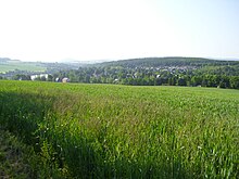
Paulsdorf (Dippoldiswalde)
|
Paulsdorf
Large district town of Dippoldiswalde
Coordinates: 50 ° 54 ′ 54 ″ N , 13 ° 38 ′ 26 ″ E
|
||
|---|---|---|
| Height : | 338 m | |
| Residents : | 733 (2017) | |
| Incorporation : | January 1, 1996 | |
| Incorporated into: | Malter | |
| Postal code : | 01744 | |
| Area code : | 03504 | |
|
Location of Paulsdorf in Saxony |
||
Paulsdorf is a state-approved resort and district of the Saxon large district town Dippoldiswalde in the district of Saxon Switzerland-Eastern Ore Mountains .
geography
location
Paulsdorf is about three kilometers northwest of Dippoldiswalde. The Malter dam , which is fed by the Rote Weißeritz , is located directly east of Paulsdorf . The Erashöhe is northwest of the village and the Steinbachsberg is southeast .
Neighboring places
Paulsdorf is in the north of Seifersdorf , in the west of Ruppendorf , in the east of Malter , in the south-west of Reichstädt , in the south of Berreuth , in the south-east of Dippoldiswalde .
history

Paulsdorf is laid out as a Waldhufendorf and is first mentioned in 1312 as Pauwilsdorf . Between the years 1564 to 1639 there was a Vorwerk . The local farmers had to do their job at the Berreuth manor . In 1464 Paulsdorf was part of the Dippoldiswalde care, 1565 to the Berreuth office and from 1590 to the Dippoldiswalde office . From 1856 to 1875 the administrative affiliation was with the Dippoldiswalde court office, then with the office of the same name . In November 1760 the Imperial Habsburg Regiment Pallavicini quartered itself with all 3 associations, the Grenadier Companie in the association of the Imperial Army under Imperial General Ludwig von Seckendorf , FMLT Guasco and FZM Macquire in Paulsdorf, Paulshain and Seifen for the winter. In 1837 the Paulsdorf basic mill above the Malter mill is mentioned. The Maltermühle on Paulsdorfer Flur is mentioned as early as 1586. The sheep farm of the manor Berreuth was at the upper end of the village and burned down in 1856, but was rebuilt. In 1925 the population of Paulsdorf consisted of 157 Evangelical Lutheran and eleven Catholic residents. In 1950 the neighboring village of Paulshain was incorporated. Two years later, Paulsdorf became part of the Dippoldiswalde district , which emerged from the administration. With the neighboring municipality of Malter Paulsdorf was united to Malter-Paulsdorf in 1974 ; this community separated in 1991 again into two independent communities. The districts of Dippoldiswalde and Freital merged in 1994 and from then on formed the Weißeritzkreis . A renewed union with Malter took place in 1996 only five years after the two communities separated. Paulsdorf, Malter and Seifersdorf merged to form the new municipality of Malter, which was incorporated into Dippoldiswalde in 2003. In 1956 it was recognized as a health resort. The Paulsdorf adventure pool was inaugurated on June 21, 1996 .
Prayer pillars
There are two prayer pillars in the village , presumably from the Holy Way , which were moved from today's reservoir to their current location when the dam was built. A wayside shrine on the road to Seifen shows biblical images on all sides, the second wayside shrine at the lake view shows the biblical image of the crucifixion. Both were made in the late Gothic period (before 1539).
dam
With the construction of the dam from 1909 to 1912, parts of the towns of Malter, Paulsdorf and Seifersdorf that were in a small housing estate in the current reservoir disappeared. The Paulsdorf lido was built in 1914, the Seeblick restaurant in 1915 and a new school in 1913 on Paulsdorfer Flur, which forms the border to the neighboring village of Seifersdorf with the outdoor pool and individual houses. Due to communal conditions, the entrance sign in the Seifersdorf district already points to Paulsdorf.
Development of the population
Development of the population of Paulsdorf:
|
|
Place name forms
The name of the place Paulsdorf changed historically as follows:
- 1312: Pauwilsdorf
- 1412: Pauwelstorff
- 1464: Pawelstorff
- 1486: Paulstorff
- 1506: Peulsdorff
- 1548: Paulsdorff
- 1627: Balsdorff
See also
Web links
- Paulsdorf on dippoldiswalde.de
- Paulsdorf in the Digital Historical Directory of Saxony
Individual evidence
- ↑ a b Population figures for Dippoldiswalde and districts on dippoldiswalde.de
- ↑ Municipalities 1994 and their changes since January 1st, 1948 in the new federal states , Metzler-Poeschel publishing house, Stuttgart, 1995, ISBN 3-8246-0321-7 , publisher: Federal Statistical Office (with the indication January 1st, 1991)
- ↑ https://www.destatis.de/DE/ZahlenFakten/LaenderRegionen/Regionales/Gemeindeververzeichnis/NamensGrenzAenderung/NamensGrenzAenderung.html StBA: municipality changes (with the indication January 1, 1990)
- ↑ a b c Paulsdorf in the Digital Historical Directory of Saxony


