
District of Saxon Switzerland-Eastern Ore Mountains
| coat of arms | Germany map |
|---|---|

|

Coordinates: 50 ° 55 ' N , 13 ° 52' E |
| Basic data | |
| Existing period: | 2008– |
| State : | Saxony |
| Administrative headquarters : | Pirna |
| Area : | 1,654.19 km 2 |
| Residents: | 245,586 (Dec. 31, 2019) |
| Population density : | 148 inhabitants per km 2 |
| License plate : | PIR, DW, FTL, SEB |
| Circle key : | 14 6 28 |
| NUTS : | DED2F |
| Circle structure: | 36 municipalities |
| Address of the district administration: |
Castle courtyard 2/4 01796 Pirna |
| Website : | |
| District Administrator : | Michael Geisler ( CDU ) |
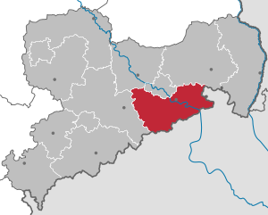
| Location of the district of Saxon Switzerland-Eastern Ore Mountains in Saxony | |
  |
|
The district of Sächsische Schweiz-Osterzgebirge is a district in Saxony , which extends over the area south of Dresden to the Czech border.
geography
The district of Saxon Switzerland-Eastern Ore Mountains is located south of the state capital Dresden . Adjacent areas are the Czech Ústecký kraj in the east and south, the district of central Saxony in the west, Dresden and the district of Meißen in the north, and the district of Bautzen in the northeast . The core area of the district includes the eponymous regions Saxon Switzerland and Eastern Ore Mountains and their foreland, but also the foothills of the Lusatian mountains in the northeast . The Elbe flows through the middle of the circle . The lowest point of the district is on the banks of the Elbe on the border with Dresden at 109 m, the highest point is the Kahleberg near Zinnwald at 905 m .
The west of the district is in the Eastern Ore Mountains and its foreland, in the catchment area of the Roten and Wild Weißeritz , which still unite in the district to form the Weißeritz .
As a result of the hull areas of the Pultscholle , the landscape consists mainly of the valleys and plateaus under agricultural and forestry use. To the south, to the ridge of the Eastern Ore Mountains, the altitude increases steadily. The Landberg near Pohrsdorf , the Windberg in Freital, the Golberoder Zughübel with the Babisnau poplar , the mountains of the Karsdorf Fault with the Wilisch , the Luchberg near Luchau and the Geisingberg form striking landmarks .
Well-known standing waters are the Malter dam , which is used for tourism, and the Lehnmühle and Klingenberg dams , which are required for drinking water . In Lauenstein which was created by 2006 retention basins Müglitztal . Significant forest areas in the west of the district are the Tharandt Forest , the Dippoldiswalder Heide and the Bärenfels forest district . The geographical center of Saxony is in the Tharandt Forest near the health resort Hartha .
The east of the district is shaped by Saxon Switzerland with the Elbe Valley. Saxon Switzerland continues east into the Lausitzer Bergland and west into the Ore Mountains. Striking landmarks here are the Große Zschirnstein and the Große Winterberg .
history

| year | Residents |
|---|---|
| 2008 | 255.459 |
| 2009 | 253.843 |
| 2010 | 252,308 |
| 2011 | 246.275 |
| 2012 | 245.927 |
| 2013 | 245.939 |
| 2014 | 245,954 |
| 2015 | 247.412 |
| 2016 | 246.066 |
| 2017 | 245.418 |
| 2018 | 245.611 |
| 2019 | 245,586 |
The district of Saxon Switzerland-Eastern Ore Mountains was formed as a result of the district reform on August 1, 2008 through the merger of the districts of Saxon Switzerland and Weißeritzkreis formed during the 1994 district reform . The name of the new district was controversial among the government and the population. The name Elbe-Weißeritz-Kreis , proposed by the Interior Ministry , was rejected by a majority by the district councils, but Saxon Switzerland-Eastern Ore Mountains seemed too long to many.
The seat of the district office was Pirna determined. Dippoldiswalde , the district town of the Weißeritzkreis, became a large district town . The cities of Pirna, Dippoldiswalde, Freital and Sebnitz thus have the special status of large district town. There are citizens' offices of the District Office in all major district towns.
On January 1, 2011, Altenberg incorporated the neighboring city of Geising , creating the district's largest municipality with an area of 145.81 km². Since January 2009, the Sonnenstein Castle in Pirna has been renovated and converted into the seat of the District Office. The renovation work was completed in December 2011, and from December 19, 2011 the district headquarters will be on the Sonnenstein . On January 1, 2012, Porschdorf to Bad Schandau and on 1 October 2012, the community was Kirnitzschtal according Sebnitz incorporated. The Sebnitz administrative community was thus dissolved. Another area change was made on December 31, 2012, it included the formation of the new community of Klingenberg from Höckendorf and Pretzschendorf . On this occasion, the administrative community was also renamed. On January 1, 2014 the community Schmiedeberg was incorporated into the city of Dippoldiswalde.
In 2015, the district hit the headlines nationwide due to xenophobic protests and riots in Freital and Heidenau, among others . The reason for this was the establishment of new asylum seekers' homes in the municipalities of the district as a result of the sharp rise in the number of refugees in 2015.
politics
District Administrator and District Council
In the Saxon local elections on June 8, 2008, the previous district administrator of the Saxon Switzerland district, Michael Geisler (CDU) was able to prevail in the first ballot with 52.4% of the votes against five other applicants and thus became the first district administrator of the newly founded district.
In the district council, the CDU is the strongest force with 26 seats, ahead of the AfD with 25 seats.
| Parties and constituencies | Percent 2019 |
Seats 2019 |
Percent 2014 |
Seats 2014 |
Percent 2008 |
Seats 2008 |
|
|---|---|---|---|---|---|---|---|
| CDU | Christian Democratic Union of Germany | 29.0 | 26th | 40.3 | 37 | 43.9 | 38 |
| AfD | Alternative for Germany | 27.9 | 25th | 9.8 | 8th | - | - |
| FW | Free voters | 12.9 | 11 | 10.7 | 9 | 11.4 | 10 |
| THE LEFT. | THE LEFT. | 10.1 | 9 | 15.1 | 13 | 18.3 | 16 |
| GREEN | Alliance 90 / The Greens | 7.5 | 6th | 4.7 | 4th | 3.6 | 3 |
| SPD | Social Democratic Party of Germany | 5.4 | 4th | 7.5 | 6th | 7.4 | 6th |
| FDP | Free Democratic Party | 5.2 | 4th | 5.3 | 4th | 7.9 | 7th |
| NPD | National Democratic Party of Germany | 2.1 | 1 | 6.5 | 5 | 7.5 | 6th |
| BWV | Bärensteiner voter association | - | - | 0.1 | - | - | - |
| total | 100 | 86 | 100 | 86 | 100 | 86 | |
| Turnout in percent | 66.3 | 53.9 | 49.3 | ||||
After the 2019 election, the following parliamentary groups were formed in the district council: CDU (26 members), AfD (25 members), FW (11 members), DIE LINKE. (9 members), GRÜNE (6 members), SPD (4 members), FDP (4 members). The district council member of the NPD is non-attached.
coat of arms

|

|
|
|
Saxon Switzerland
|
Weißeritzkreis
|
Blazon : “By a curved silver tip, in which a black hammer and a black mallet crossed at an angle , split; in front in green oblique silver wave bar; behind in gold red armored and tongued black lion . "
The colors white and green point to Saxony, the Meissen lion to the historical affiliation to the Margraviate of Meissen . The white wavy band symbolizes the wealth of rivers, the green the wealth of forests in the district. Mallets and irons are a reference to the traditional mining industry and the industrialization that continues to shape today.
The design of the coat of arms comes from Wolfgang Burkhardt from Freital. The three-part basic form of the coat of arms is similar to the coat of arms of the old Weißeritz circle, from which the Meißner lion and mallet and iron also come. The white-green wavy band was the coat of arms of the old district of Saxon Switzerland. The county coat of arms was approved on November 13, 2008. The associated coat of arms statute came into force on November 26, 2008.
Administrative division
cities and communes
The district of Saxon Switzerland-Eastern Ore Mountains has consisted of 36 municipalities since January 1, 2014 , including 19 towns. Four cities are “major district cities”. The town with the most inhabitants in the district is Freital (39,703 inhabitants) followed by the district town of Pirna with 38,422 inhabitants. The most populous municipality is Bannewitz with 11,104 inhabitants. Rathen has the fewest inhabitants (349 inhabitants). At the same time, Rathen is also the smallest municipality in the district. With around 40 times the area of Rathen, the city of Altenberg has the largest share of the district area. (Population figures as of December 31, 2019)
|
Cities
|
Communities
|
  |
|---|


Administrative communities
In the district, several municipalities have formed a total of nine administrative communities .
- Administrative community Altenberg with the member communities Altenberg and Hermsdorf / Erzgeb.
- Administrative community Bad Gottleuba-Berggießhübel with the member communities Bad Gottleuba-Berggießhübel, Bahretal and Liebstadt
- Administrative community Bad Schandau with the member communities Bad Schandau, Rathmannsdorf and Reinhardtsdorf-Schöna
- Administrative community Dohna-Müglitztal with the member communities Dohna (VG headquarters) and Müglitztal
- Administrative community Klingenberg with the member communities Hartmannsdorf-Reichenau and Klingenberg
- Administrative community Königstein / Sächs. Schw. With the member communities Gohrisch, Königstein (Saxon Switzerland), Rathen, Rosenthal-Bielatal and Struppen
- Administrative community Lohmen / Stadt Wehlen with the member communities Lohmen (VG headquarters) and Stadt Wehlen
- Administrative association Pirna with the member communities Dohma and Pirna
- Administrative community Tharandt with the member communities Dorfhain and Tharandt
The Sebnitz administrative community with the member communities Kirnitzschtal and Sebnitz existed until September 30, 2012 .
Area changes in the district
| date | AGS | local community | modification | AGS | receiving community |
|---|---|---|---|---|---|
| 01/01/2011 | 14628120 | Geising, city | Inclusion in | 14628010 | Altenberg, city |
| 01/01/2012 | 14628280 | Porschdorf | Inclusion in | 14628030 | Bad Schandau, city |
| 10/01/2012 | 14628200 | Kirnitzschtal | Inclusion in | 14628360 | Sebnitz, city |
| December 31, 2012 | 14628180 | Höckendorf | Neoplasm too | 14628205 | Klingenberg |
| 14628290 | Pretzschendorf | ||||
| 01/01/2014 | 14628350 | Schmiedeberg | Inclusion in | 14628060 | Dippoldiswalde, city |
Economy and Infrastructure
In the Future Atlas 2016 , the district of Saxon Switzerland-Eastern Ore Mountains was ranked 296 out of 402 districts, municipal associations and independent cities in Germany, making it one of the regions with a "balanced risk-opportunity mix".
economy

The region was starting from mining coined in the 19th century heavily industrial. In the Döhlen basin in particular, many companies such as the Freiherrlich von Burgker hard coal and iron works developed through the mining of hard coal in the age of industrialization . Tin ore was mined and processed in Altenberg until 1991 , while uranium ore was extracted in Freital and Königstein and mineral water in Burkhardswalde. Saxon Switzerland is still a supplier of natural stone ( sandstone , porphyry, gravel) today . In addition, all major branches of industry were located in the 19th and 20th centuries, especially in Freital, Heidenau, Schmiedeberg, Pirna, Sebnitz, Dippoldiswalde. The many emissions from the factories resulted in high levels of pollution in the air and water in many places. During the industrialization, factories of many branches of industry also settled here. The rural area is used for agriculture, in the area of the Dresden Elbe valley (Borthen, Pesterwitz, Pirna) even special crops (fruit growing, viticulture, hops) are indigenous. Larger forest areas (Tharandt, Altenberg, Saxon Switzerland) are used for forestry.
Today, Saxon Switzerland, more than the Eastern Ore Mountains, is shaped by tourism . After the fall of the Wall, many industrial companies were closed or downsized and their areas were converted. Still, there are companies like the stainless steel plant in Freital.
In October 2013, 9,537 people were registered as unemployed in the Pirna employment agency district, which covers the entire district. This corresponds to a rate of 7.4% of all civilian labor force.
traffic

The federal highways 170 (Dresden - Altenberg ), 171 ( Wolkenstein - Dippoldiswalde ), 172 (Pirna - Schmilka ) and 173 ( Lichtenfels - Hof - Chemnitz - Dresden ) as well as the federal motorway 17 (Dresden - Prague ) with the six junctions run through the district Dresden-Südvorstadt , Dresden-Prohlis , Heidenau i. Sa. , Pirna , Bahretal and Bad Gottleuba . The federal motorway 4 ( Erfurt - Görlitz ) with the Dresdner Tor service area also runs for a few kilometers through the northwestern district.

Local public transport is mainly handled by the regional transport company Regionalverkehr Sächsische Schweiz-Osterzgebirge GmbH. She is a member of the Upper Elbe Transport Association .
The most efficient railway lines in the district are the Děčín – Bad Schandau – Pirna – Dresden-Neustadt and Dresden – Freital – Chemnitz – Werdau lines , and the Pirna – Coswig , Bautzen – Sebnitz – Bad Schandau , Kamenz – Dürrröhrsdorf– lines are also used for local rail passenger transport. Pirna , Neustadt – Dürrröhrsdorf , Rumburk – Sebnitz and Heidenau – Altenberg health resort are important. With the Weißeritztalbahn there is also a daily narrow-gauge railway line . Another special feature is the Kirnitzschtalbahn tram route . The district is connected to the Dresden S-Bahn network via the Dresden S-Bahn lines S1, S2 and S3. Furthermore, with the EuroCity stop in Bad Schandau station, there is a connection to the international long-distance traffic of Deutsche Bahn AG and Czech Railways .
There is an airfield in Pirna- Pratzschwitz . The next major commercial airport is Dresden Airport .
Protected areas
There are 28 designated nature reserves in the district (as of March 2017).
License Plate
On 1 August 2008 the district was the since 1 January 1991 valid for the district Pirna distinguishing sign PIR assigned. Since 12 November 2012, in connection with the license plate liberalization also DW (Dippoldiswalde), FTL (Freital) and SEB (Sebnitz) available.
See also
Web links
Individual evidence
- ↑ Population of the Free State of Saxony by municipalities on December 31, 2019 ( help on this ).
- ↑ Information for 14 6 28 district of Saxon Switzerland-Eastern Ore Mountains in the Saxony regional register
- ↑ The first give in. In: Sächsische Zeitung , November 9, 2006
- ↑ Press release ( Memento of the original from December 21, 2011 in the Internet Archive ) Info: The archive link has been inserted automatically and has not yet been checked. Please check the original and archive link according to the instructions and then remove this notice. on the district's website
- ^ Result of the 2008 district council election . Accessed December 8, 2008 .
- ↑ Eligible voters, voters, ballot papers, distribution of votes and seats in the election on May 25, 2014 in the Saxon Switzerland-Eastern Ore Mountains district. State Statistical Office of Saxony, accessed on April 1, 2015 .
- ^ The coat of arms of the Saxon Switzerland-Eastern Ore Mountains district
- ↑ Population of the Free State of Saxony by municipalities on December 31, 2019 ( help on this ).
- ↑ Future Atlas 2016. (No longer available online.) Archived from the original on August 9, 2016 ; accessed on March 23, 2018 . Info: The archive link was inserted automatically and has not yet been checked. Please check the original and archive link according to the instructions and then remove this notice.
- ↑ Press release: The job market in October ( Memento of the original from November 3, 2013 in the Internet Archive ) Info: The archive link was inserted automatically and has not yet been checked. Please check the original and archive link according to the instructions and then remove this notice.