
Tharandt Forest


The Tharandt Forest , formerly also known as the Grillenburg Forest , is a landscape in the center of Saxony and is located southwest of the forest town of Tharandt , south of the town of Wilsdruff , roughly between Freiberg and Dresden . Administratively today it is almost entirely part of Tharandt, with the districts Grillenburg and Tharandt, and bears the legally protected word and image mark with the text: Tharandter Wald - the most beautiful forest in Saxony , which emerged from tourist advertising in the 1920s. In addition, the Tharandt forest provides oneGeopark of national importance, in which one can find geological outcrops of rocks from several geological ages in a very small space .
history
In the 12th century the village of Warnsdorf existed for a short time in the center of the forest on the water-rich Warnsdorf spring in the Triebisch catchment area . In the neighboring village of Grillenburg , which is still completely surrounded by the forest , the foundation walls of an extensive Romanesque complex from the 13th century were found. There is also evidence that the Grillenburg sandstone has been mined since the 13th century . The Fürsten- or Herrenweg led through the Tharandt Forest . During the early modern period , the forest was used for hunting by the sovereigns ( Jagdschloss Grillenburg ) as well as for wood and charcoal production for mining ( charcoal burning ) and the royal seat of Dresden ( rafting ). In addition, silver mining took place around the Tharandt forest , especially at Mohorn - Grund and Edle Krone , and quarries were operated right into the forest. Also forest glassworks from the 14th century are in Hetzdorf (Glaser reason) and the spa town of Hartha (broken glass) detectable. The Zeidler (forest beekeepers and forest rangers), who lived in Fördergersdorf am Pohrsdorfer Rand (formerly called Zeidler ) and the health resort Hartha am Hartheberg , also supplied wax and honey. Artificial ponds in the forest are still used for fish farming today .
At the beginning of the 18th century, the Tharandt Forest, in Tännichtgrund near Naundorf , was the hideout of the notorious robber Lips Tullian and his Black Guard . The Lips-Tullian rock named after him and the even older thief's chamber remind of his whereabouts .
Around 1800 the forest area was severely run down and was restored from 1811 by Heinrich Cotta according to scientific principles. The Tharandt forest served as a model of the sustainable forestry that was born from the wood shortage . Then in 1816 the Royal Saxon Forest Academy and in 1811 the Forest Botanical Garden in Tharandt was founded from the private forestry school brought by Heinrich Cotta from Zillbach in Thuringia .
From the 19th century onwards, it served the recreation of middle-class families, especially from Dresden, including recently well-known personalities from science and art such as Heinrich Ernemann and Eva von der Osten , who set up their summer residences here. At the time of National Socialism , Saxony's Gauleiter, Reichsstatthalter and Landesjägermeister Martin Mutschmann chose the Grillenburg hunting lodge as the seat of the Saxon Jägerhof in 1936 . His guest house Neues Jägerhaus , built in 1938, was also used by him himself and served as the VdN recovery home Elsa Fenske for victims of fascism during the GDR era .
The entire forest has been a local recreation area for a long time and has already been signposted by the central spa administration of the Tharandt municipal association and helpers from the Kulturbund and equipped with nature trails under the technical guidance of the TU Dresden , specializing in forest sciences Tharandt . As a closed and easily accessible natural area, the Tharandt Forest continues to be used for local recreation for the residents of the surrounding regions and their guests. There are nature trails and paths for hiking, riding and cycling activities, which are looked after by the Sachsenforst state enterprise , associations and municipalities. On some routes, carriage and sleigh rides are possible.
The region around the Tharandter Forest has been represented since 1997 by the Tharandter Forest Queen , which is publicly advertised every two years and z. B. as part of the traditional choir meeting at the Tharandt forest or the state forest day of action again seeing forest and wood is presented and crowned by the transport and beautification association "Tharandter Wald" eV .
geography
The landscape of the Tharandt Forest cannot be clearly assigned. According to some beliefs, it is included in the Eastern Ore Mountains adjoining it to the south , but due to its altitude of around 220 m above sea level , it can be counted . NN in the valley of the Wild Weißeritz up to a point 359 m above sea level. NN north-west of Klingenberg and Colmnitz to the north-eastern part of the Erzgebirge foothills . The highest elevations are the Tännicht in the southwest with 461 m above sea level and the Landberg on the northern edge with 426 m above sea level. NN .
In the northeast, at the confluence of the Wilder Weißeritz and Schloitzbach , lies the town of Tharandt. It also includes the health resort Hartha , north of the forest, with its districts and the places Pohrsdorf and Großopitz . In the northwest is the place Mohorn (city of Wilsdruff) with the district Grund (at the foot of the Landberg ), where incense candles are produced. The Triebisch , which rises in the Tharandt forest and flows into the Elbe near Meißen, flows through this district . In the southwest lie Hetzdorf and Niederschöna (municipality Halsbruecke ) and to the south of the forest closes on the edge of the to bobritzsch-hilbersdorf belonging Naundorf on.
The Sachsenhof station settlement further south-east at the Klingenberg-Colmnitz station on the Saxon-Franconian mainline belongs to the municipality of Klingenberg with the districts of Colmnitz and Klingenberg. The station was once an important junction for narrow-gauge railways . To the south-east there is a drinking water reservoir, the Klingenberg reservoir, which supplies Dresden, among other things. Dorfhain and Höckendorf with Edle Krone are old mining areas. Shortly before Edle Krone, the Sachsen-Franken-Magistrale of the railway leads from the Seerenbachtal into the Weißeritztal, the route and the place were badly affected by the floods in 2002 . This main line is almost completely identical to the southern boundary of the Tharandt Forest and is one of the steepest standard-gauge railway lines in Europe (1:39). In the east, the Somsdorf and Weißig districts border the town of Freital .
About 1.5 km east of Naundorf and about 4.5 km southwest of Grillenburg is the geographic center of Saxony at the so-called thieves' chamber , in Tännichtgrund, in the Grillenburg district of the health resort Hartha.
Tharandt Forest natural area

The Tharandt forest, which lies in an old volcanic basin - a caldera - has a submontane altitude with strong climatic differences and mostly barren, acidic soils . It can therefore only be used for forestry , whereby the spruce forest predominates, but a mixed forest is aimed for, for example, by sub-building the spruce stands with oak and beech seedlings , which is closer to natural forest cover (including sessile oak and beech forest).
For the Tharandt forest students, the forest serves as a green lecture hall with numerous forest botanical attractions and good hiking opportunities, which also characterize it as a local recreation area for the entire Central Saxon area.
In the south-eastern part of the forest north of the Markgrafenstein there is an immission ecological test field for research purposes , the development of which can be traced back to the occurrence of smoke damage, in particular from the smoke emissions from the Freiberg mining and smelting area and the commissioning of the Halsbrücker Esse .
Mention should also be made of the Seerenteich on the southern edge of the Tharandt Forest, a former raft pond with a turquoise color.
geology
The Tharandt Forest has a special reputation as a square mile of geologists, as good outcrops of all main rock types can be found here in the immediate vicinity. It serves as a popular excursion destination for students from the nearby Freiberg Mining Academy and TU Dresden .
The geological history of the subsoil of the Tharandt forest is essentially shaped by three components. In the beginning there was the collapse of a prehistoric volcanic area and thus the formation of a caldera . This was followed by sedimentary deposits from the Cretaceous period for a long time and finally tertiary quartzite deposits near the Landberg .
The porphyry fan at Mohorn-Grund is a geological outcrop created by earlier quarrying activities. The formed by volcanic activity approximately 320 million years ignimbrite is rugged there during the cooling process and entering volume shrinkage perpendicular to zones of the same temperature. At the outcrop, the fissures (left) and columns (right) can be seen. This outcrop belongs to the Tharandt volcanic complex .
Niederschöna is known for its Cretaceous sandstone deposits , which stretch as far as the Grillenburg sandstone in the center of the Tharandt Forest, from whose material many architectural parts for buildings in the Freiberg, Meißner and Dresden regions and, most recently, millstones were created. The Niederschöna layers of the Elbe Valley chalk are named after the village of Niederschöna as a type locality . They consist of a sequence of diagenetic compacted pebbles and sands from the course of prehistoric low Schönaer flow , in the direction of the east-southeast meandering flowed to chalk sea. He brought material from more distant western regions of today's Saxony . His pebbles contain quartz , rhyolithoids , lydite , slate , diabase and quartz in the form of amethysts , so they are multicolored. These gravel can be consolidated by a fine-grain matrix or are relatively loose. Their layers form the basis of all subsequent chalk layers over a large area.
According to the differentiated processes during the formation, aeolian (so-called dune sandstone ), fluvial and limnic (inland lake areas) sediments are contained in this layer sequence . Only later were these deposits captured by the sea of chalk and its marine sediments ( sub- cuboid sandstone / upper ugly formation ) covered. Sandstone was quarried in several places in the Tharandt Forest. The stone was extracted in the sandstone layers of the river and sea sediments. In the fine-grained sandstones there are claystone deposits that contain a lot of fossilized plant remains. These layers are called Credneria layers , after the Saxon geologist Hermann Credner .
The palaeontological specimens of the Upper Cretaceous collected here by Hanns Bruno Geinitz are now among the scientifically particularly valuable holdings in Dresden's natural history collections . They went into his nationally cited standard works on the geology of the chalk and contributed significantly to the understanding of this geological age.
On the west wall of the Ascherhübels, on the so-called Hexenhäusl, there are imposing columns made of nephelinite (phenobasalt), which slowly move from a vertical position outwards into a horizontal position. It is a magma dome from the period of the Young Tertiary before about 14 mya (Miocene), whereby the position is perpendicular to the cooling surfaces of the magma, the vertical columns of the outcropping wall belong to the direct magma slot. Basically, the nephilinite has a very fine-grained and dense structure, but experienced a transformation and increase in volume due to water absorption on the surface, which ultimately causes the granular-vesicular structure there ( sunburner basalt ).
A special feature is the so-called Kugelpechstein from Spechtshausen . The natural monument around 300 meters south of the village of Spechtshausen , a little northwest of the health resort Hartha, is an ignimbritic rock with a glassy solidification from a volcanic extrusion in the Upper Carboniferous (250 to 300 million years ago) with a rhyodacite composition. This is remarkable in that the outcrop of the The deep lava dome only extends over a few square meters and the volcanic glass shows no signs of devitrification despite its age .
The geological open-air museum with the geological hiking trail connects these outcrops between Tharandt and Mohorn-Grund.
gallery
- Pictures from the Tharandt forest
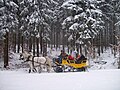
Post sledge in the winter forest

Seerenteich raft system near Dorfhain

Hunting column with boundary stones near Hetzdorf

King Albert killed the 1000th red deer near the health resort of Hartha in 1892

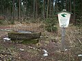
Entrance to the Grillenburg forest experience
Salt lick near Kurort Hartha

Hunting tower near Niederschöna
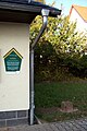
Oldest forest boundary stone from 1549 in the health resort Hartha

Forest surveying monument from 1740 in Spechtshausen

Refuge horse stable on the raftsman path
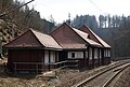
Blockhaus -Bahnhof Edle Krone in the shape of a horse peg from the mining industry


See also
cards
- Topographic map TK 25, sheets 4946 Mohorn, 4947 Wilsdruff, 5046 Freiberg and 5047 Freital as well as the geological map GK 25, sheets 4946 Tanneberg, 4947 Wilsdruff, 5046 Freiberg and 5047 Tharandt
- Staatsbetrieb Geobasisinformation und Vermessung Sachsen (Ed.): Hiking map Tharandter Wald , sheet 31 (topographic map, edition with hiking trails, 1:25 000) 3rd edition, August 2008, ISBN 978-3-86170-082-1
- Rolf Böhm: Tharandt Forest hiking map. The first forest in Saxony . (1:20 000) 1st edition Bad Schandau 2004. ISBN 3-910181-19-8
literature
- André Kaiser: "What the forester told in the evening by the fireplace" - legends from the Tharandt forest , Sächsische Zeitung (ed.), Regionalverlag Freital (brochure, 32 pages, no year)
- André Kaiser: The great stately hunts (1562-1903) in the Tharandt-Grillenburger Forest , Harthaer Gemeindeblätt'l, Official Gazette of the Kurort Hartha community, December 1996
- Kulturbund der DDR , Ortsgruppe Tharandt (Ed.): Der Tharandter Wald , Forststadt Tharandt, Contributions to Heimatgeschichte, Issue 7, Tharandt 1982
- Uwe Nösner: From the Jagdpfalz to the green university. The Tharandt Forest - historical approaches and local history excursions . Saxonia Publishing House. Dresden 2015. ISBN 3-944210-44-1
- Silvio Stute: A journey through time around the Tharandt Forest , self-published, Freital 2017
- Herbert Wotte , Joris Wotte : Tharandter forest . Wanderheft, No. 17. 12th edition. Tourist-Verlag, Berlin and Leipzig 1990
- Between Tharandt forest, Freital and the Lockwitztal (= values of our homeland . Volume 21). 1st edition. Akademie Verlag, Berlin 1973.
Individual evidence
- ^ Trademark number: DE 39401066, registered on June 6, 1995
- ↑ Deutsche Vulkanologische Gesellschaft eV excursion note with picture ( memento from September 30, 2014 in the web archive archive.today )
- ^ Hanns Bruno Geinitz (* 1814 in Altenburg; † 1900 in Dresden). In: www.kreidefossilien.de. Archived from the original on October 6, 2014 ; accessed on September 30, 2014 .
- ↑ W. Pälchen (ed.) / H. Walter (ed.): Geology of Saxony. Geological structure and history of development . Stuttgart 2008. pp. 286-287 ISBN 978-3-510-65239-6
Web links
- The coal pile in Tharandt
- Local history contributions on the website of the city of Tharandt
- Tharandter Wald , website of the Green League Osterzgebirge eV
- Landscape profile of the Tharandt Forest of the Federal Agency for Nature Conservation ( information )
Coordinates: 50 ° 57 ′ 32 " N , 13 ° 29 ′ 50" E