
Niederschöna
|
Niederschöna
Halsbrücke parish
|
||
|---|---|---|
 |
||
| Height : | 348 m above sea level NN | |
| Residents : | 2073 (Apr 30, 2005) | |
| Incorporation : | January 1, 2006 | |
| Postal code : | 09633 | |
| Area code : | 035209 | |
Location of Niederschöna in Saxony |
||

Niederschöna is a district of the municipality of Halsbrücke in the district of Central Saxony . The community of Niederschöna and its districts was incorporated into Halsbrücke on January 1, 2006.
geography
Location and traffic
The district is located on the western edge of the Tharandt forest in the valley of the Rodelandbach, a right-hand tributary of the Bobritzsch , about eight kilometers north of the district town of Freiberg . The federal highway 173 leads through the village from Freiberg to Dresden . In addition, the place is connected to the public transport network.


Neighboring places
| Oberschaar | Haida , enlighten | |
| Krummenhennersdorf |
.svg)
|
Hetzdorf |
| Falkenberg | Naundorf | Grillenburg |
history
In the years 1228–1230, Niederschöna is mentioned for the first time as a sovereign village, lent to the von Mergenthal family, a Meißnisch-Saxon noble family, which gained reputation and wealth through the Freiberg mining . The place name is derived from the lower beautiful floodplain (1364 Schonaw , 1427 Neder Schona , 1691 Niederschöna ). Mentioned around 1350 as Allodium Schonaw , the Waldhufendorf belonged to the castrum Tharandt in 1378 . The manorial rule over the place was between 1551 and 1764 at the manor Krummenhennersdorf . The Niederöna Hereditary Court is mentioned in 1447 when the Freiberg council appealed against what it believed to be unjustified brewing and malting by the Niederschöna heirs. It was located in the middle of the village, was at the same time a strong inn and had a small quarry. The Chaussee led through the court of the Hereditary Court, a road that followed from Freiberg to Dresden on the trail of an older Hufenweg until the 19th century and served as a post road.
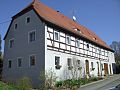
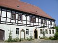
The village has been shaped by agriculture since the village was founded. A number of farms and houses still exist in half-timbered construction . In addition to agriculture, mining was an important source of income in earlier times. The König-August-Erbstolln mine that was built in 1704 was the most important mining company in Niederschöna. A high point in the existence of this mine was the visit of the Russian Tsar Peter I in 1711. The mine operation was continued in 1715 due to the unworthiness of the ore veins on the Falkenberg valley side.
Niederschöna and the places Hetzdorf, Wüsthetzdorf and Hutha that arose on its corridor formed a southern exclave of the Electoral Saxon or Royal Saxon District Office of Meißen until 1836 . From 1836 the four places briefly belonged to the Freiberg district office . In 1856, Niederschöna became part of the Freiberg Court Office and, after the judiciary and administration were separated, in 1875, the Freiberg District Administration .
Between 1923 and 1971 the place had a stop on the narrow-gauge railway Klingenberg-Colmnitz-Oberdittmannsdorf . The water house, water crane and a freight wagon are reminiscent of the small railway line, which is now a hiking and cycling route . Two mills once worked in Niederschöna, the “Obermühle” until around 1890 and the “Niedere Mühle” until around 1975. The Agricultural Production Cooperative (LPG) “Otto Buchwitz” Niederschöna was founded in 1952. From this, the agricultural cooperative Niederschöna eG emerged with the areas of plant production, animal production and the biogas plant that went into operation in December 2002 . The biogas plant generates 330 kilowatts of electrical power and has a gas storage of 900 cubic meters. Input materials are liquid manure and silage maize.
On July 1, 1950, Oberschaar and its part of the municipality Haida were incorporated into Niederschöna. From July 25, 1952, the community of Niederschöna belonged to the Freiberg district in the Chemnitz district (renamed the Karl-Marx-Stadt district in 1953 ), which was continued as the Saxon district of Freiberg from 1990 and became part of the Central Saxony district in 2008. On March 1, 1994 the merger with Hetzdorf took place to form the rural community of Niederschöna in the Freiberg district.
On January 1, 2006, the incorporation into Halsbrücke took place because the municipality of Niederschöna was in debt with 8.2 million euros and was no longer able to act.
The former middle school, converted into a primary school, was inaugurated on August 7, 2009. The school building dates back to 1888. The old school, built in 1819 (today a residential building), with the church and the parish farm, represent an effective building ensemble.
The OPAL pipeline , which was completed in November 2011, runs from the landfall near Lubmin to Olbernhau in the Ore Mountains. The pipe storage facility was located in the Niederschöna section in 2009/2010. A bending machine was also used here, with which the pipe sections were adapted to the hilly terrain.
Development of the population
1551: 52 possessed men and 109 inhabitants
1764: 35 possessed men, 23 gardeners, 22 cottagers on 31 hooves 16–18 bushels each .
As of December 31st :
|
1834 to 1946
|
1950 to 2004
|
Incorporations
| Former parish | date | annotation |
|---|---|---|
| Enlightened | before 1875 | Incorporation to Herrndorf |
| Herrndorf | 04/01/1948 | Incorporation to Hetzdorf |
| Hetzdorf | 03/01/1994 | Incorporation to Niederschöna |
| Hutha | before 1875 | Incorporation to Herrndorf |
| Niederschöna | 01/01/2006 | Incorporation after Halsbrücke |
| Oberschaar (with Haida) | 07/01/1950 | Incorporation to Niederschöna |
| Oberschaar, manor district | around 1922 | Incorporation to Oberschaar |
| Wüsthetzdorf | 01/01/1887 | Incorporation to Hetzdorf |
Buildings
Church Niederschöna
The current baroque shape of the Niederschöna church with roof turret and flat-roofed rectangular hall with double galleries corresponds to the renovation of 1716. The bevelled round arched door walls in the choir area belong to the older building fabric, dated around 1600 . The large baptismal font shows late Gothic ornamentation . Particularly noteworthy is the single-manual organ by the Saxon master organ builder Gottfried Silbermann from 1716.

Church of Niederschöna (from Saxony's church gallery 1838)

Sankt-Annen-Kirche Niederschöna

Southwest view

Memorial plaques for the dead of the Franco-German War and the First World War
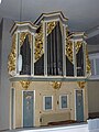
Silbermann organ from 1716

Baptismal font with late Gothic ornamentation


Niederschöna sandstone


The extraction of sandstone in several quarries in the municipality and in the Tharandt forest was of great economic importance for the residents of Niederschönau . Many architectural parts for buildings in the Freiberg area were made from the Niederschöna sandstone . Electoral Saxon post mile pillars , especially the coat of arms of the distance pillars , in the Ore Mountains also often consist of this rock. In 1915 the operation was stopped. Of the numerous former sandstone quarries in and near Niederschöna, the one at the forester's house is best preserved. The finds of prehistoric plants in the claystone layers of the Niederschöna layers named after this type locality (modern Niederschöna Formation ) have entered geological history through Hanns Bruno Geinitz and have gained international attention in the geoscientific field. Here are sandstone, mudstone and siltstone and paleogeographic at the base layers river gravel in alternating layers one above the other. The gravel are relics of a prehistoric river course. Häntzschel (1934) declared individual sandstone layers of this sediment sequence to be dune sandstone . However, the upper layers are of marine origin (glauconite content, creep traces of living beings), have a marine basal conglomerate, and in the layers above the Oberhäslich Formation and the Dölzschen Formation there is compact sandstone as a marine deposit. Based on these characteristics, a later river estuary is assumed, which developed into the shallow sea zone near the coast. The fluctuating advance of the sea and the same kind of retreat in combination with a prehistoric undulating terrain left behind a complicated layer structure in the sediment sequence between Grillenburg and Niederschöna. These geological outcrops and later research boreholes within the scientific history of Saxony are of particular importance for understanding the paleogeographical relationships between Cretaceous deposits in the Dresden area .
Former husband and wife Niederschöna
The mansion (Wiesenweg 7) of the previous free good Niederschöna, was rebuilt in 1910 and turned into a convalescent home for sick Tbk-1946th From around the late 1960s it was used as a nursing home for older citizens. At the moment only the extensions of the once stately mansion remain.
A historical outline of the Niederschöna estate is given by the following naming of the previous owners of the estate from 1600 onwards.
The first visible traces of the property can be found in a map by Markscheider Oeder around 1580:
"Hans Heinrich von Schönbergks gutt" - next to a "court of law" (the hereditary court), two mills and "Hans Heinrich v. Schönbergs holtz ”, a forest that was cleared more than 100 years later and forms the village hall of a large part of Hetzdorf. Based on the purchase books in the Freiberg district archive and the baptism, marriage and death registers of the Niederschöna Church, the following owners of the property can be verified:
|
|
On the history of the manor house (Wiesenweg 7)
- 1934–1937: The town of Niederschöna takes over the building of the children's home to set up a labor camp
- 1937–1945: Children's home of the "Deutsche Kinderschar" with the name "Hans-Schemm-Heim"
- 1945–1946: Hospital for war wounded
- 1945–1946: Pestalozziheim for training new teachers
- 1947–1964: Tbc-Kurheim, closed due to decline in tuberculosis
- 1967–1994: Nursing Home
- 2002: Demolition of the former manor buildings
- 2006: Sale of the home building to private owners

Niederschöna manor house, picture postcard from around 1910

Manor house extension, street side

The extension, west side, left transition to the former manor house

Extension building, until 1964 Tbc-Kurheim


Aviator memorial

On a farm road run by the agricultural cooperative next to the "Schumann-Linde", an aviator monument erected in 1913 commemorates the crash of a military aircraft of the Albatros- Farman biplane type on September 21, 1912, in which both officers were killed. The funeral service for the two aircraft occupants, Johannes Berger, 29 years old, officer in the Royal Saxon Infantry Regiment "Crown Prince" No. 104 in Chemnitz and Curt Junghans, 36 years officer in the Royal Saxon Infantry Regiment No. 134 in Plauen , took place in the church Niederschöna on September 22nd in the presence of the relatives, the regimental comrades and many locals. Then the injured pilots were transferred to their hometowns in Dresden-Plauen and Gleisberg near Roßwein . At Bauer Schumanns Linde (Schumann-Linde) a memorial was built to commemorate the victims of the accident. The consecration took place on June 1, 1913, during which the Saxon Crown Prince Georg laid a wreath. The names of the two officers are on an oval bronze plate on an obelisk-like column. The 100th anniversary of the plane crash was the occasion to reconstruct the memorial square with significant involvement of the relatives of the accident victim Johannes Berger. For information, a granite stone slab with two photos was also inserted in the monument square.
The planned event for the 100th anniversary of the crash of an airplane on the Niederschöna corridor had to be canceled due to a tragic event. On September 17, 2012, 100 years after the plane crash, an airplane crashed again near the site of the accident, killing a Freiberg pilot, 22 years old, and his passenger. The crashed plane at a Freital flight school was an ultralight aircraft of the type "Storch 528".

Schumann-Linde and Aviator Monument, November 2010

Aviator memorial after the restoration in August 2012

Bronze plate of the aviator memorial

Signs on the Schumann-Linde (memorial tree)
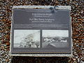
Stone slab with photos of the plane crash


.JPG)

Stone cross from Niederschöna

Near the church, in the old cemetery directly in front of the vicarage barn, there is a sandstone cross with an incised sword. The stone cross is an atonement or murder cross and is considered the oldest evidence of the presence of people in today's local area (before the village was founded). Another stone cross is located on private property on the "Krähenhübel" north of the former sandstone quarry. This stone cross is shaped like a Maltese cross and has no incisions. It was found on a field and is said to have stood on a grave of a butcher who was shot by the French in 1813.
- Pictures from Niederschöna
Niederschöna (from Saxony's church gallery 1838)

School, rebuilt in 2009
Old school, built in 1819

Four-sided courtyard
Rectory (marked 1824)

Former blacksmith's shop, built in 1807

Place pyramid

Biogas plant


.JPG)


literature
- Niederschöna . In: August Schumann : Complete State, Post and Newspaper Lexicon of Saxony. 7th volume. Schumann, Zwickau 1820, p. 321.
- Gerhard Platz: Golden days, pictures from the Freiberg mining area . Landesverein Sächsischer Heimatschutz Dresden, Volume XXII, Issue 10/12, 1933.
- Freiberger Land (= values of our homeland . Volume 47). 1st edition. Akademie Verlag, Berlin 1988.
- Christine Zimmermann: Niederschöna - history (s) between Tharandt forest and Bobritzschtal , published by the municipality of Halsbrücke, 1st edition 2009.
- Richard Steche : Niederschöna. In: Descriptive representation of the older architectural and art monuments of the Kingdom of Saxony. 3. Issue: Amtshauptmannschaft Freiberg . CC Meinhold, Dresden 1884, p. 112.
Web links
- Niederschöna in the Digital Historical Directory of Saxony
- Manorial estate in Niederschöna in the Dresden Main State Archives
- Private website of Niederschöna (out of date)
- Neck bridge online ; therein: Niederschöna
- Freiberg church district - Niederschöna-Oberschaar parish ; therein: Church Niederschöna
Individual evidence
- ↑ a b Freiberger Land (= values of our homeland . Volume 47). 1st edition. Akademie Verlag, Berlin 1988. p. 83
- ^ Ernst Heinrich Kneschke (ed.): New general German nobility lexicon . Volume 6, Voigt, Leipzig 1865, pp. 243-244.
- ↑ Niederschöna . In: August Schumann : Complete State, Post and Newspaper Lexicon of Saxony. 7th volume. Schumann, Zwickau 1820, p. 321.
- ^ Karlheinz Blaschke , Uwe Ulrich Jäschke : Kursächsischer Ämteratlas. Leipzig 2009, ISBN 978-3-937386-14-0 , p. 46 f.
- ↑ Niederschöna, Hetzdorf, Wüsthetzdorf and Hutha as places in the Freiberg district office, book "Handbuch der Geographie", pp. 618 and 629f.
- ^ The Amtshauptmannschaft Freiberg in the municipality register 1900
- ^ Agricultural cooperative Niederschöna (including the biogas plant)
- ↑ Oberschaar on gov.genealogy.net
- ^ Hetzdorf on gov.genealogy.net
- ↑ StBA: Changes in the municipalities in Germany, see 2006
- ↑ Niederschöna in the Digital Historical Directory of Saxony
- ^ A b Directory of communities and places for the Kingdom of Saxony, 1904, publisher: Statistical Bureau of the Royal Ministry of the Interior
- ↑ W. Pälchen (ed.) / H. Walter (ed.): Geology of Saxony. Geological structure and history of development . Stuttgart 2008. pp. 317-319 ISBN 978-3-510-65239-6
- ↑ Frank Haubrich, Mareike Eberlein: The Tharandt forest as a symbol of the geology of Saxony . Excursion guide to the annual conference of the German Soil Science Society. 2007 ( Page no longer available , search in web archives ) Info: The link was automatically marked as defective. Please check the link according to the instructions and then remove this notice.
- ↑ The Niederschöna estate at www.sachsens-schloesser.de
- ↑ Christine Zimmermann: Niederschöna - history (s) between Tharandter Wald and Bobritzschtal , published by the community of Halsbrücke, 1st edition 2009.
- ↑ Freiberger Land (= values of our homeland . Volume 47). 1st edition. Akademie Verlag, Berlin 1988. p. 84
- ↑ Cristine Zimmermann: Plane crash on Niederschonaer Flur, Halsbrücker Anzeiger, 2012, No. 9, p. 15; 16
- ↑ Freiberger and his co-pilot died in a plane crash Freie Presse on September 17, 2012
- ↑ MDR-Nachrichten: Halsbrücke: Two dead in the crash of a small plane ( page no longer available , search in web archives ) Info: The link was automatically marked as defective. Please check the link according to the instructions and then remove this notice.
- ↑ Storch ( Memento of the original from March 4, 2016 in the Internet Archive ) Info: The archive link was inserted automatically and has not yet been checked. Please check the original and archive link according to the instructions and then remove this notice.