
Krummenhennersdorf
|
Krummenhennersdorf
Halsbrücke parish
Coordinates: 50 ° 58 ′ 45 ″ N , 13 ° 21 ′ 45 ″ E
|
||
|---|---|---|
| Height : | 304 (280-360) m | |
| Residents : | 537 (1990) | |
| Incorporation : | March 1, 1994 | |
| Postal code : | 09633 | |
| Area code : | 03731 | |
Location of Krummenhennersdorf in Saxony |
||

Krummenhennersdorf is a district of the municipality of Halsbrücke in the district of central Saxony (Free State of Saxony ). It was incorporated on March 1, 1994.
Location and traffic
location

Krummenhennersdorf is about eight kilometers north of the district town of Freiberg and three kilometers north of Halsbrücke in a small side valley of the Bobritzsch at an altitude of between 280 and 360 m above sea level. NN . To the southeast of the village on a plateau lies the small scattered settlement of forest houses. The Rothschönberger Stolln , a water solution tunnel of the Brander and Freiberg mountain district, runs west of the village .
traffic
The district is connected to the local public transport network and can be easily reached nationwide via the B 173, both from Freiberg and from Dresden .
Neighboring places
| Gotthelffriedrichsgrund | Reinsberg | Dittmannsdorf |
| Pond houses (to Rothenfurth ) |
.svg)
|
Oberschaar |
| Neck bridge | Conradsdorf | Falkenberg |
history
_Rittergut.jpg)
_Rittergut.jpg)
In the forest hoof village of Krummenhennersdorf, which was built around 1160, Margrave Albrecht the proud , eldest son Otto the rich, died in 1195 as a result of poisoning. In 1334 the village was still spelled Heynrichsdorf (village of Heinrich), in the same year the place name Krumme Heinrichisdorf can be traced. Other place names are: 1439 Krummehennersdorf , 1574 Heinersdorf , 1578 Crumenhennersdorf and 1791 Krumhennersdorf . To the southeast of the village on a plateau lies the small scattered settlement of forest houses. The village of Forst, mentioned in 1350, could have been here, which later fell into desolation .
Regarding the manorial rule, Krummenhennersdorf was divided into two parts by the brook for a long time. The western part belonged to the Bieberstein manor as a preliminary work , the eastern part with the church to the Altzella monastery . The manor house there was the abbot's summer residence. With the secularization of the monastery in 1540/45, it was given to Andreas Glasewald, the last abbot of the monastery, for life. After his death in 1560, the property fell to the Margraves of Meißen , who elevated it to a manor and sold it as a fief to Nicol von Schönberg from Reinsberg at the beginning of the 17th century . During the Thirty Years' War the property was sold to the von Hartitzsch family and then returned to the von Schönberg family through marriage through the von Miltitz and the Pflugk von Tiefenau family in 1801, who held the property until it was expropriated by the land reform in 1945. In addition to the eastern part of the village, the Krummenhennersdorf lordship included the villages of Sand with Grüneburg, Niederschöna , Hetzdorf and Hutha .
The arch bridge over the Bobritzsch was built in 1806. The mining was of little importance compared to the side debris of the Halsbrücker Spats . The Goldene-Aue-Erbstolln was still in operation in 1833.
The sovereign administrative districts of the village were the Castrum Freiberg in 1378, the Freiberg District Office in 1548, around 1696 and until 1836 the Electoral Saxon or Royal Saxon District Office of Meissen . From 1836 Krummenhennersdorf again briefly belonged to the Freiberg district office . In 1856 Krummenhennersdorf became part of the Freiberg judicial office and, after the judiciary and administration were separated, in 1875 it became part of the Freiberg district administration.
The main building of the manor Krummenhennersdorf was demolished after the fire in 1945. A farm building is still inhabited today. Furthermore, the park of the manor has been preserved to the present day.
As a result of the second district reform in the GDR , the municipality of Krummenhennersdorf became part of the Freiberg district in the Chemnitz district (renamed the Karl-Marx-Stadt district in 1953 ), which was continued as the Saxon district of Freiberg from 1990 and was added to the central Saxony district in 2008. With the incorporation of the municipality of Krummenhennersdorf to Halsbrücke, the place has been part of Halsbrücke since March 1, 1994.
Development of the population
1551: 41 possessed men , 2 gardeners , 51 residents , 37¾ hooves .
1764: 24-obsessed man, seven gardeners, 14 cottagers , 32½ per hooves 15-20 bushel .
As of December 31st:
|
1834 to 1925
|
1939 to 1990
|
Attractions
- Kandlerkirche
- Detailed views of the Kandlerkirche


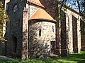


The church, which dominates the village with its protruding tower, was built in 1900 by Woldemar Kandler in a moderate historicizing form. It replaced the old miner's church in the village. The foundations of the old church, which was demolished around 1903, still exist on the old cemetery included in the park. The keystones and other architectural parts that have been preserved, as well as tombs from the 17th and 18th centuries, are located here. The remains of the late Gothic altar shrine are in the Freiberg City and Mining Museum . From 1993 to 2002 the church was renovated in several construction phases.

- Kunstgraben and Krummenhennersdorfer Mühle
A popular hiking trail is the moat tour , which begins at the Wünschmannmühle , along the artificial moat through the Bobritzschtal valley to Reinsberg . The Krummenhennersdorfer mill was first mentioned in 1195. In 1460 she received the privilege of delivering bread for Freiberg, in 1637 bread could be sold from the mill. Today's mill building was built after the fires of 1900 and 1910. The mill was shut down in 1980 and the bread bakery closed in 1985. Today the mill with the mill technology around 1922 is a technical monument and museum.
literature
- Freiberger Land (= values of our homeland . Volume 47). 1st edition. Akademie Verlag, Berlin 1988.
- Richard Steche : Krummenhennersdorf. In: Descriptive representation of the older architectural and art monuments of the Kingdom of Saxony. 3. Issue: Amtshauptmannschaft Freiberg . CC Meinhold, Dresden 1884, p. 102.
Web links
- Krummenhennersdorf in the Digital Historical Directory of Saxony
- Neck bridge online ; therein: Krummenhennersdorf
- Krummenhennersdorf manor in the main state archive in Dresden
Individual evidence
- ↑ Freiberger Land (= values of our homeland . Volume 47). 1st edition. Akademie Verlag, Berlin 1988. p. 77
- ↑ Karlheinz Blaschke (Ed.): Historical local directory of Saxony , new edition, Leipzig 2006, ISBN 3-937209-15-8 , p. 223
- ↑ Ernst Eichler , Hans Walther (ed.): Historisches Ortnamesbuch von Sachsen , Berlin 2001, ISBN 3-05-003728-8 , Volume II, p. 265
- ^ Bieberstein in the book "Handbuch der Geographie", p. 596.
- ^ The Krummenhennersdorf manor in the German Digital Library
- ^ Website of the von Schönberg family association
- ^ Karlheinz Blaschke , Uwe Ulrich Jäschke : Kursächsischer Ämteratlas. Leipzig 2009, ISBN 978-3-937386-14-0 ; P. 46 f.
- ↑ Krummenhennersdorf as a place in the Freiberg district office, book "Handbuch der Geographie", p. 600f.
- ^ The Amtshauptmannschaft Freiberg in the municipality register 1900
- ↑ The manor Krummenhennersdorf on www.sachsens-schloesser.de
- ↑ Krummenhennersdorf on gov.genealogy.net
- ↑ cf. Krummenhennersdorf in the Digital Historical Directory of Saxony