
Reinsberg (Saxony)
| coat of arms | Germany map | |
|---|---|---|

|
Coordinates: 51 ° 0 ′ N , 13 ° 22 ′ E |
|
| Basic data | ||
| State : | Saxony | |
| County : | Central Saxony | |
| Height : | 335 m above sea level NHN | |
| Area : | 49.71 km 2 | |
| Residents: | 2834 (Dec. 31, 2019) | |
| Population density : | 57 inhabitants per km 2 | |
| Postcodes : | 09629, 09634 | |
| Primaries : | 037324, 035209 | |
| License plate : | FG, BED, DL, FLÖ, HC, MW, RL | |
| Community key : | 14 5 22 480 | |
| Community structure: | 9 districts | |
| Address of the municipal administration: |
Kirchgasse 2 09629 Reinsberg |
|
| Website : | ||
| Mayor : | Bernd Hubricht ( CDU ) | |
| Location of the municipality of Reinsberg in the district of central Saxony | ||
  |
||


Reinsberg is a municipality in the district of central Saxony , about 35 km west of Dresden , near the cities of Freiberg and Meißen . The nine districts of the municipality with 3,000 inhabitants are located east of the Freiberg Mulde in the center of the Free State of Saxony . With the establishment of the Altzella monastery in the middle of the 12th century and silver ore discoveries around Freiberg, the rural settlement areas emerged.
Geography and landscape
.jpg)
The municipality of Reinsberg is located in the middle of the eastern foothills of the Erzgebirge foothills between the Eastern Ore Mountains and the Lommatzscher Pflege . The Freiberger Mulde forms the western boundary of the municipality . Starting from the south, the Bobritzsch flows northwards , which flows into the Freiberg Mulde within the municipality between Bieberstein and Hirschfeld . The Rothschönberger Stolln , a water solution tunnel of the Brander and Freiberg mountain district, runs through the community . He has a light hole in the Neukirchen area .
The village of Reinsberg in the municipality of the same name includes the district of Drehfeld in the north-western district on "Nordstraße" / "Hirschfelder Straße" ⊙ and the Wolfsgrün district in the south-eastern district on "Freiberger Straße" in the direction of Krummenhennersdorf . ⊙
geology
In geological terms, the municipality represents the northern boundary of a large area characterized by crystalline slate and gneiss , which extends further south from the Eastern Ore Mountains to the central Ore Mountains.
Neighboring communities
The following communities border ( clockwise , starting in the northwest) on the community of Reinsberg: Nossen , Klipphausen , Wilsdruff , Halsbrücke and Großschirma .
| Nossen | Nossen | Clip houses |
| Large company |
.svg)
|
Wilsdruff |
| Large company | Neck bridge | Wilsdruff |
Community structure
The municipality of Reinsberg today consists of nine districts in five localities :
| Localities | Districts |
|---|---|
| Bieberstein | Bieberstein, Burkersdorf , Gotthelffriedrichsgrund |
| Dittmannsdorf | Dittmannsdorf |
| Hirschfeld | Hirschfeld with Friedland |
| Neukirchen | Neukirchen, Steinbach |
| Reinsberg | Reinsberg with Wolfsgrün, rotating field |
history

.jpg)

Reinsberg originated in the 12th century. The establishment of the place is connected with the establishment of the Altzelle monastery built by Cistercian monks and the discovery of silver ores in the Freiberg area . From 1168 onwards, most of the village settlements were created in this region.
The silver mining and the settlement by Franconian farmers at the time of the high medieval country development shaped the place. They set up settlements in the form of row villages with Waldhufen ( Waldhufendörfer ), estate blocks and Franconian four-sided farms . Around 1550 there were 47 " possessed men " (landowners) and 52 residents in Reinsberg. At that time the place consisted of 28 hooves in terms of size (in Saxony there were 12, 15, 18, 24 and 30 acre hooves, with the acreage being 5,534,230 m²).
At the Freiberger trough that emerged Burg Reinsberg . As early as 1197, the district of Reinsberg was the seat of a knightly noble family of the same name, as can be seen today in the castles in Reinsberg and Bieberstein as well as several manors. The ideal location for medieval conditions, the steep slope above the Bobritzsch , which is difficult to access , was probably the reason for a German knight by the name of Reinhard to establish the permanent seat of Regensberg (later Reinsberg). To protect the villages and to secure the tithe income of the margraviate of Meissen and the diocese , noble families in the region were enfeoffed with mansions that built castles as residences. The castle name thus became the name of the place Reinsberg and the Reinsberg family . In the 14th century, the Reinsbergers lost ever larger parts of their ancestral home, including part of the village of Reinsberg. These shares were acquired by the von Schönbergs, in part through other sexes .
Finally, in 1411, the von Schönberg family acquired the rest of the headquarters from the Reinsbergers. The castle passed into their possession. After that, the von Schönbergs resided at Reinsberg Castle and the extensive rulership that went with it for over 500 years. The von Schönberg influence extended from the Meißner Land to the Ore Mountains . In 1572 the property in Oberreinsberg was divided with the Reinsberg Castle and Niederreinsberg with the Niederreinsberg manor.
The place name "Reinsberg" has changed several times in the course of its history and there were different spellings. The following spellings have been handed down from historical sources:
- 1197: Reinhardus de Regensberg
- 1198: Regensburch
- 1205: Regenstein
- 1219: Regensberg
- 1255: Regensberc, Reinsberc
- 1350: Reinsperg
- 1378: Reynsberg
- 1428: Rensperg
- 1485: Reinsperg
- 1551: Nider-, Ober-Reynsperk
- 1791: Ober- and Nieder-Reinsberg are two special Güther
- 1875: Reinsberg (Nieder- and Ober-)
Ober- and Niederreinsberg as well as the Wolfsgrün in the corridor of Oberreinsberg belonged to the Electoral Saxon and Royal Saxon District Office of Meißen until 1836 . From 1836 the places with the manorial rule Reinsberg briefly belonged to the Freiberg district office . In 1856 Reinsberg was incorporated into the Nossen court office and in 1875 the Meißen administration . At that time, Drehfeld was politically part of the Reinsberg. When the empire was founded in 1871, the population had increased to 893 inhabitants.
With the expansion of the Potschappel – Wilsdruff narrow-gauge railway to Nossen in 1898, the Dittmannsdorfer Bach valley was connected to the later Wilsdruffer network of Saxon narrow-gauge railways . The following stations emerged in the area of today's municipality of Reinsdorf:
- District Dittmannsdorf: stations Oberdittmannsdorf and Niederdittmannsdorf
- District Reinsberg: stations Oberreinsberg and Niederreinsberg
- Bieberstein district: Obergruna –Bieberstein station
The Oberdittmannsdorf stop became a separation station after the First World War , where the 1921–1923 line to Klingenberg-Colmnitz branched off , which had connections to Frauenstein and the standard-gauge Dresden – Werdau railway at Klingenberg-Colmnitz station . Passenger traffic took a back seat to freight traffic, which was ultimately discontinued in 1972. Parts of the former route were expanded as a hiking trail after the political change in the GDR .
As a result of the second district reform in the GDR , the municipality of Reinsberg came to the Freiberg district in the Chemnitz district in 1952 (renamed the Karl-Marx-Stadt district in 1953 ), which was continued as the Freiberg district of Saxony from 1990 . On March 1, 1994, the communities of Bieberstein , Dittmannsdorf , Neukirchen and Reinsberg were merged to form the new community of Reinsberg. The districts of Reinsberg and Drehfeld have since formed one of five localities in the municipality of Reinsberg.
In 1998 an administrative community was formed with the city of Siebenlehn . After the administrative community of Reinsberg-Siebenlehn was dissolved in 2003, the heavily indebted town of Siebenlehn was incorporated as a district into the previous municipality of Großschirma on September 1, 2003 , which was thus granted town charter. It was the first incorporation of a city into a municipality in Saxony.
The municipality of Reinsberg has been part of the Central Saxony district since 2008.
Incorporations
| Former parish | date | annotation |
|---|---|---|
| Bieberstein | March 1, 1994 | |
| Burkersdorf | July 1, 1950 | Incorporation to Bieberstein |
| Dittmannsdorf | March 1, 1994 | |
| Rotating field | before 1875 | |
| Gotthelffriedrichsgrund | October 1, 1934 | Incorporation to Burkersdorf |
| Hirschfeld (with Friedland) | March 1, 1994 | |
| Neukirchen | March 1, 1994 | |
| Steinbach | July 1, 1950 | Incorporation to Neukirchen |
| Wolf green | before 1875 |
Population development
The number of inhabitants is numbered on December 31 of the given year.
| year | Residents |
|---|---|
| 1548/51 | 47 possessed men , 52 residents |
| 1764 | 19 possessed men, 28 cottagers |
| 1834 | 664 |
| 1871 | 893 |
| 1890 | 815 |
| 1910 | 764 |
| 1925 | 774 |
| year | Residents |
|---|---|
| 1939 | 760 |
| 1946 | 1,119 |
| 1950 | 1,077 |
| 1964 | 963 |
| 1990 | 686 |
| 1998 | 3,409 |
| 1999 | 3,340 |
| year | Residents |
|---|---|
| 2000 | 3,350 |
| 2001 | 3,300 |
| 2002 | 3,276 |
| 2003 | 3,275 |
| 2004 | 3,301 |
| 2005 | 3,259 |
| 2006 | 3,247 |
| year | Residents |
|---|---|
| 2007 | 3,247 |
| 2008 | 3,221 |
| 2012 | 3,010 |
| 2013 | 2,998 |
Sources: Digital Historical Directory of Saxony , State Statistical Office of the Free State of Saxony
coat of arms
The coat of arms of the place shows three hills on the shield. On the central hill there is a conifer, on the left and right there is a deciduous tree.
Regular events
Widespread festivities in rural areas such as Walpurgis Night , Maypole Festival , annual celebrations by associations such as the shooting club, which has held bird shooting every year for over 200 years, and that of the volunteer fire brigade have their place in Reinsberg in the event year.
politics
mayor
Bernd Hubricht (CDU) has been the mayor of the municipality of Reinsberg since 1994. He was elected on June 8, 2008 with 82.6% of the votes and confirmed in office in June 2015 with 95.4% of the votes.
Municipal council
Since the municipal council election on May 26, 2019 , the 15 seats of the municipal council have been distributed among the individual groups as follows:
- CDU : 6 seats
- Association of fair local taxes of the community of Reinsberg e. V. (VGK): 5 seats
- Regional farmers' association Erzgebirge e. V. (RBV): 2 seats
- LEFT : 2 seats
Culture and sights
- see also: List of cultural monuments in Reinsberg
Buildings
The most famous buildings in the community are the castles of Reinsberg and Bieberstein .
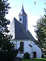
The church in Reinsberg is said to have been a pilgrimage church (place of grace) in which, according to a letter from the College of Cardinals in Rome , 100 days of indulgence were promised to those who went to the church on the first of the month ( Latin : Kalendae ) to pray and make sacrifices .
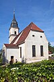
In addition, regional historical references have the church in Neukirchen, where Kunz von Kauffungen is said to have found his final resting place after his beheading, the war mill in Steinbach and the village church in Dittmannsdorf. From 1960 to 1998 the only remaining bell (cast year 1518) of the old Frauenkirche in Dresden, which is now part of the ringing of the Frauenkirche again, was part of its ringing.
The BadePark Reinsberg was built in 1978 by VEB Gaskombinat Schwarze Pump as an outdoor pool for holiday guests at Schloss Reinsberg. The timelessly modern architecture was designed by students at the Bauhaus Weimar and encompasses a modern bathing area. The bath park should therefore be unique in the bathing landscape. It borders directly on the Lindenallee and the Grave Tour , a hiking trail with historical mining history in the nature reserve of the same name between Reinsberg and Krummenhennersdorf .
The almost completely preserved daytime facilities at the IVth Lichtloch of the Rothschönberger Stolln are also reminiscent of the nearby Freiberg mining industry . Consisting of shaft building , Huthaus , Mountain carpentry, Bergschmiede (only foundation remains available) existing and Powder Tower, and asked a listed building complex provides an insight into the state of Saxony ore mining in the second half of the 19th century.

Church in Neukirchen

Kriegers Mill in Steinbach

Reinsberg Castle

Funkes Mühle in Neukirchen, courtyard view
Dittmannsdorf Church
Reinsberg Church


Memorials
A grave slab by the painter Hellmuth Rudolph on a grave site in the cemetery in the Neukirchen district commemorates a column of several hundred concentration camp prisoners on a death march in March 1945, six of whom remained murdered and were buried here.
Economy and Infrastructure
Around 200 companies and traders are based in Reinsberg. A locational advantage of the community is the proximity to the Nossen motorway triangle and the good connection to the cities of Dresden , Chemnitz and Leipzig . The federal highway 14 with the junction Nossen Ost is two kilometers away, the distance to the junction Siebenlehn of the federal highway 4 is four kilometers.
Sons of the community
- Karl Viktor Ryssel (1849–1905), Protestant theologian (Old Testament scholar and Old Orientalist); Professor in Leipzig and Zurich.
- Woldemar Kandler (1866–1929), architect and church builder in Saxony
- Paul Roitzsch (1888–1979), teacher, archivist and local history researcher
- Lothar Kwasnitza (1929–1983), architect
Personalities
- Kunz von Kauffungen (1410–1455), Saxon nobleman who is said to have found his final resting place in the church in Neukirchen
- Christian Gottlob Steinmüller (1792–1864), builder of the church organ in Reinsberg
literature
- Cornelius Gurlitt : Reinsberg. In: Descriptive representation of the older architectural and art monuments of the Kingdom of Saxony. 41. Issue: Administrative Authority Meißen-Land . CC Meinhold, Dresden 1923, p. 409.
- A. Kühne / A. Ranft: History and stories in and around Wilsdruff - A home book for the Wilsdruffer Land , association for natural and local history (ed.), Wilsdruff 1930/1931; here: Reprint of the Landesverein Sächsischer Heimatschutz e. V., local group Wilsdruff (ed.), Meißner Tageblatt Verlags GmbH, Wilsdruffer Tageblatt 1994, ISBN 3-929705-01-X
Individual evidence
- ↑ Population of the Free State of Saxony by municipalities on December 31, 2019 ( help on this ).
- ↑ Locations of the municipality of Reinsberg
- ^ Reinsberg Castle at www.sachsens-schloesser.de
- ↑ Rittergut Niederreinsberg on www.sachsens-schloesser.de
- ↑ Digital historical place directory of Saxony .
- ^ Karlheinz Blaschke , Uwe Ulrich Jäschke : Kursächsischer Ämteratlas. Leipzig 2009, ISBN 978-3-937386-14-0 ; P. 46 f.
- ^ Reinsberg as a place in the Freiberg district office, book "Handbuch der Geographie", p. 606
- ^ The Meißen district administration in the municipal register 1900
- ^ StBA: Changes in the municipalities in Germany, see 2003
- ↑ a b c d State Statistical Office of the Free State of Saxony: Area changes
- ↑ a b Municipalities 1994 and their changes since January 1st, 1948 in the new federal states , Metzler-Poeschel publishing house, Stuttgart, 1995, ISBN 3-8246-0321-7 , publisher: Federal Statistical Office
- ↑ a b Lists of the municipalities incorporated since May 1945 and evidence of the breakdown of the independent manor districts and state forest districts, 1952, publisher: Ministry of the Interior of the State of Saxony
- ^ A b Directory of communities and places for the Kingdom of Saxony, 1904, publisher: Statistical Bureau of the Royal Ministry of the Interior
- ^ The Sachsenbuch, Kommunal-Verlag Sachsen KG, Dresden, 1943
- ^ Reinsberg (Nieder-, Ober-) - HOV | ISGV eV Accessed October 3, 2019 .
- ^ State Statistical Office of the Free State of Saxony: Statistics - Statistics. Retrieved October 3, 2019 .
- ↑ Association of Liberal Local Politicians ( page no longer available , search in web archives ) Info: The link was automatically marked as defective. Please check the link according to the instructions and then remove this notice. (PDF; 47 kB)
- ↑ Results of the 2019 municipal council elections
Web links
- Atlas Central Saxony
- Official website of the municipality of Reinsberg
- Reinsberg in the Digital Historical Directory of Saxony
- Wolfsgrün in the Digital Historical Directory of Saxony
Bieberstein | Burkersdorf | Dittmannsdorf | Rotating field | Gotthelffriedrichsgrund | Hirschfeld | Neukirchen | Reinsberg | Steinbach