
Großhartmannsdorf
| coat of arms | Germany map | |
|---|---|---|

|
Coordinates: 50 ° 48 ' N , 13 ° 19' E |
|
| Basic data | ||
| State : | Saxony | |
| County : | Central Saxony | |
| Height : | 509 m above sea level NHN | |
| Area : | 32.2 km 2 | |
| Residents: | 2474 (Dec. 31, 2019) | |
| Population density : | 77 inhabitants per km 2 | |
| Postal code : | 09618 | |
| Area code : | 037329 | |
| License plate : | FG, BED, DL, FLÖ, HC, MW, RL | |
| Community key : | 14 5 22 200 | |
| Address of the municipal administration: |
Hauptstrasse 106 09618 Großhartmannsdorf |
|
| Website : | ||
| Mayor : | Werner Schubert ( CDU ) | |
| Location of the community Großhartmannsdorf in the district of central Saxony | ||
  |
||

Großhartmannsdorf is a municipality in the district of Central Saxony in the Free State of Saxony .
geography
The Waldhufendorf Großhartmannsdorf is located on a tributary to the Freiberger Mulde . There are three ponds of the Revierwasserlaufanstalt in the village : the Lower , Middle and Upper Großhartmannsdorfer Pond . The Kohlbach-Kunstgraben , which indirectly connects the Upper Pond with the Middle and Lower Pond and continues to Brand-Erbisdorf, runs west around the town .
To the south of Großhartmannsdorf are the districts of Nieder-, Mittel- and Obersaida. These Waldhufendörfer are located on the course of the Saidenbach . In Obersaida, too, there is an artificial pond that is part of Freiberg's artificial moat system.
- Local division
The following districts belong to Großhartmannsdorf:
Großhartmannsdorf has approx. 2700 inhabitants and is divided into:
- tenth
- Lohsen
- Helbigsdorf settlement
- Obermühle
- Neuwaltersdorf
history


Großhartmannsdorf was founded as a Waldhufendorf in the 12th century. The first documentary mention was made in 1368 as Hartmanstorph. Some other spellings of the place name are Hardtmansdorff (1432), Grossen Hartmansdorf (1435), Großhartmannsdorff (1581).
The name means village of a (Mr.) Hartmann. The later addition Groß- served to distinguish it from Kleinhartmannsdorf .
Großhartmannsdorf came into the possession of the Benedictine monastery in Chemnitz . 1375 exchanged the Benedictine Chemnitz Großhartmannsdorf against the property of the Lords of Waldenburg located domination Rabenstein .
After the Waldenburgs became extinct, the place with the rule of Selva as the office of Selva in 1479 came to the Saxon Elector . In 1548 the village came to the Freiberg district office .
Since 1696 the manor and the place Großhartmannsdorf belonged again to the office of Wolkenstein. Großhartmannsdorf was separated from the core area of the office by the area of today's districts Obersaida , Mittelaida and Niedersaida , which belonged to the Lauterstein office. In 1832 the place came again to the Freiberg district office. From 1856 Großhartmannsdorf was under the jurisdiction of the fire department and from 1875 to the administration of the Freiberg district administration . In 1935 Neuwaltersdorf was incorporated.
From 1952 Großhartmannsdorf belonged to the Brand-Erbisdorf district and since 1994 to the Freiberg district . In 1993 Obersaida and Mittelaida were incorporated. Niedersaida followed in 1994. Since 2008 the community has belonged to the Central Saxony district .
The Evangelical Charismatic Movement began to increasingly encompass the GDR in the 1970s. Starting from a youth meeting in 1972 in Großhartmannsdorf, Saxony became a center of evangelical youth culture, the annual meetings were of national importance.
- Population development
Population development from 1982
The following population figures refer to December 31 of the previous year with the territory January 2007:
|
1982 to 1988
|
1989 to 1995
|
1996 to 2002
|
2003 to 2013
|
- Source: State Statistical Office of the Free State of Saxony
politics
Municipal council
Since the municipal council election on May 26, 2019 , the 16 seats of the municipal council have been distributed among the individual groups as follows:
mayor
Werner Schubert (CDU) has been mayor since 1994; he was re-elected in 2001, 2008 and 2015.
Culture and sights
Buildings
In Großhartmannsdorf is the manor known as the Mayoratsgut , which belonged to the Alnpeck family between 1524 and 1676 and then to the von Schönberg family until 1720 and which was owned by the von Carlowitz family from 1730 .
Only the 16th century manor house remains from the former palace complex. The farm buildings were demolished after 1945. The stair tower, which was probably built in 1565, and the seating niche portal are well worth seeing.
Under Carl Adolph von Carlowitz, the village church was rebuilt as a baroque hall church in 1737/38 . The new organ of the church was built in 1741 by the well-known organ builder Gottfried Silbermann . The late Gothic winged altar (before 1520) of the previous church is now in the parish church of Dörnthal (Olbernhau) .
The lower pond (also known as the large pond ) is the largest pond in the Ore Mountains with an area of 61 hectares. It was created around 1500 to supply the Freiberg mines with water and was later part of the Freiberg Revierwasserlaufanstalt . Today it is a protected landscape area. The middle pond is used as a natural pool.

Lower Großhartmannsdorfer pond
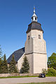
Church in Großhartmannsdorf

Local government

Mayor Council property


Memorials
The grave of two Soviet prisoners of war who fell victim to forced labor during the Second World War is located in the cemetery in the district of Mittelaida .
Economy and Infrastructure
economy
In 1878, the first German watchmaking school was founded in Großhartmannsdorf. Precision clocks were made there. Even today there are still a number of specialized craft and handicraft businesses.
traffic
.jpg)
The federal road 101 ( Silberstraße ) leads through Großhartmannsdorf itself , while the other districts are to the right and left of this main traffic route.
From 1890 to 1973 Großhartmannsdorf was the end point of the branch line Berthelsdorf (Erzgeb) –Großhartmannsdorf . The nearest train station is now the station Mulda (Sachs) on the railway line Freiberg-Holzhau , located east about seven kilometers from Großhartmannsdorf.
Sons and daughters of the church
- Carl Adolf von Carlowitz (1771–1837), Prussian lieutenant general, governor of Breslau, Russian major general
- Hans Georg von Carlowitz (1772–1840), Saxon Minister
- Alfred Brodauf (1871-1946), politician (Progressive People's Party, DDP), MdR, MdL (Saxony)
- Ruth Zechlin (1926–2007), composer
- Peter Böhme (engineer) (* 1936), engineer
literature
- August Moritz Hahn: Reminder sheet for the Großhartmannsdorf church trip to the 150th anniversary of the inauguration of the church on October 22nd, 1888 by the local priest at that time . Freiberg 1888 ( digitized version )
- Otto Härtig: Chronicle of the community Großhartmannsdorf with its districts Obersaida, Mittelaida, Niedersaida. Großhartmannsdorf municipal administration, 2000
- Richard Steche : Grosshartmannsdorf. In: Descriptive representation of the older architectural and art monuments of the Kingdom of Saxony. 3. Issue: Amtshauptmannschaft Freiberg . CC Meinhold, Dresden 1884, p. 97.
Web links
- Internet presence of the community Großhartmannsdorf
- Großhartmannsdorf in the Digital Historical Directory of Saxony
- Obersaida in the Digital Historical Directory of Saxony
- Niedersaida in the Digital Historical Directory of Saxony
Individual evidence
- ↑ Population of the Free State of Saxony by municipalities on December 31, 2019 ( help on this ).
- ↑ Karlheinz Blaschke (Ed.): Historisches Ortverzeichnis von Sachsen , new edition, Leipzig 2006, p. 304, ISBN 3-937209-15-8
- ↑ Ernst Eichler , Hans Walther (ed.): Historisches Ortnamesbuch von Sachsen , Berlin 2001, Volume I, p. 392, ISBN 3-05-003728-8
- ↑ The Wolkensteiner official places in the 19th century in the "Handbuch der Geographie", p. 251f.
- ^ Ehrhart Neubert: History of the opposition in the GDR 1949–1989 . Ch. Links Verlag, 1998, ISBN 978-3-86153-163-0 ( google.com [accessed October 18, 2015]).
- ↑ Results of the 2019 municipal council elections
- ↑ https://www.statistik.sachsen.de/wpr_alt/pkg_s10_bmlr.prc_erg_bm?p_bz_bzid=BM151&p_ebene=GE&p_ort=14522200
- ↑ website Mayoratsguts Großhartmannsdorf
- ^ Georg Dehio : Handbuch der Deutschen Kunstdenkmäler, Saxony II, administrative districts Leipzig and Chemnitz , Munich 1998, ISBN 3-422-03048-4 , page 359f