
Taura
| coat of arms | Germany map | |
|---|---|---|

|
Coordinates: 50 ° 55 ' N , 12 ° 50' E |
|
| Basic data | ||
| State : | Saxony | |
| County : | Central Saxony | |
| Management Community : | Burgstädt | |
| Height : | 304 m above sea level NHN | |
| Area : | 11.11 km 2 | |
| Residents: | 2370 (Dec. 31, 2019) | |
| Population density : | 213 inhabitants per km 2 | |
| Postal code : | 09249 | |
| Area code : | 03724 | |
| License plate : | FG, BED, DL, FLÖ, HC, MW, RL | |
| Community key : | 14 5 22 550 | |
| Community structure: | 3 districts | |
| Address of the municipal administration: |
Köthensdorfer Strasse 1 09249 Taura |
|
| Website : | ||
| Mayor : | Robert Haslinger ( CDU ) | |
| Location of the municipality of Taura in the district of central Saxony | ||
  |
||

Taura is a municipality in the west of the district of Central Saxony in Saxony . It is part of the Burgstädt administrative community .
geography
Taura is located 15 km north of Chemnitz and 15 km east of Limbach-Oberfrohna in the Saxon Granulite Mountains , which here reach a height of 347 m. The community is bordered by the Holzbach in the south, the Chemnitz in the east and the cordierite gneiss reef of the Taurastein in the west.
Local division
- Taura
- Koethensdorf
- Reitzenhain
history
The place name is probably derived from the Slavic "tur". That means something like great or aurochs . The place is first mentioned in a document as Thurowe in 1378, although it is much older .
In the witch hunts in Köthensdorf from 1679 to 1681, four cases of witchcraft and sorcery are documented. Three witch trials ended with release, the outcome is unknown.
On March 1, 1994, the municipality of Köthensdorf-Reitzenhain was incorporated, which was created in 1909 from the merger of two villages. Until January 26, 2000 the official name of the municipality was Taura b. Burgstädt .
Local partnership
politics
Municipal council
Since the municipal council election on May 26, 2019 , the 12 seats of the municipal council have been distributed among the individual groups as follows:
- Allotment Gardeners' Association of Voters (WVK): 6 seats
- CDU : 3 seats
- Voters' Association of the Köthensdorf Voluntary Fire Brigade (WFFK): 3 seats
mayor
In June 2015 Robert Haslinger (CDU) was elected as the new mayor. The predecessor in office was Klaus Vivus (non-party).
Culture and sights
- see also: List of cultural monuments in Taura
- Taurastein and the Taurastein Tower in Burgstädt
- Lindenberg
- Schusterstein near Koethensdorf
- Hockstein in Markersdorf
- Bear cave in Markersdorf
- Strudel pots in Markersdorf
- Nature trail in Markersdorf
Transport links
The B 107 runs east of the municipality and the B 95 to the south . The community can also be reached via the A 4 (connections Chemnitz-Glösa or Chemnitz-Mitte ). Before the Chemnitztalbahn was shut down in 2001, the two stations of Markersdorf-Taura (already in the Markersdorf district) and Auerswalde-Köthensdorf existed for the locations of today's municipality . Today the Chemnitz Valley Cycle Path runs along the disused route. Today the Markersdorf – Taura museum station is the starting point of the Chemnitz Valley Express , which is operated by a motorized trolley and leads over the Amselgrund and the two Chemnitz Valley viaducts to the Schweizerthal - Diethensdorf stop .
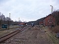
Markersdorf-Taura Museum Station (2016)

Auerswalde-Köthensdorf station (2016) with remains of track


Personalities
- Johann Esche (1682–1752), born in today's district of Köthensdorf, German stocking manufacturer
- August Peters (1817–1864), narrator
- Max Unger (1883–1959), musicologist , Beethoven researcher
- Kurt Rümmler (1911–1958), head of the Leipzig district administration of the Ministry for State Security
- Dietmar Werner (* 1938), non-fiction author, lives in Taura
literature
- Richard Steche : Taura. In: Descriptive representation of the older architectural and art monuments of the Kingdom of Saxony. 14th booklet: Amtshauptmannschaft Rochlitz . CC Meinhold, Dresden 1890, p. 93. * The district of Chemnitz in historical views. Geiger Verlag Horb am Neckar, 1992, ISBN 3-89264-730-5 (on the history of the places in the former Chemnitz district : Taura pp. 172–185)
Individual evidence
- ↑ Population of the Free State of Saxony by municipalities on December 31, 2019 ( help on this ).
- ↑ Manfred Wilde : The sorcery and witch trials in Kursachsen , Cologne, Weimar, Vienna 2003, p. 475f.
- ↑ State Statistical Office Saxony: Area changes from January 1, 2000 to December 31, 2000 (PDF file; 13.6 KB)
- ↑ Results of the 2019 municipal council election, accessed on April 10, 2020
- ^ Website of the Eisenbahnfreunde Chemnitztal e. V.
Web links
- Atlas Central Saxony
- Official website of the municipality of Taura
- Taura in the Digital Historical Directory of Saxony
- Köthensdorf in the Digital Historical Directory of Saxony
- Reitzenhain in the Digital Historical Directory of Saxony