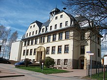
Koethensdorf
|
Koethensdorf
Taura municipality
Coordinates: 50 ° 54 ′ 30 ″ N , 12 ° 52 ′ 7 ″ E
|
||
|---|---|---|
| Incorporation : | 1909 | |
| Incorporated into: | Koethensdorf-Reitzenhain | |
| Postal code : | 09249 | |
| Area code : | 03724 | |
|
Location of Köthensdorf in Saxony |
||
Köthensdorf is a district of Taura in the district of central Saxony in Saxony .
history
Köthensdorf was first mentioned in a document in 1490. Until the 19th century the place belonged as an exclave to the office of Chemnitz .
In 1909 Köthensdorf was merged with the neighboring Reitzenhain. The municipality of Köthensdorf-Reitzenhain was incorporated into Taura on March 1, 1994.
Geography and traffic
Köthensdorf is located 15 km north of Chemnitz and 15 km east of Limbach-Oberfrohna . The B 107 runs east of the municipality and the B 95 to the south . The community can also be reached via the A 4 connections Chemnitz-Glösa or Chemnitz-Mitte. The Chemnitz flows through Köthensdorf in the east . Köthensdorf is located in the Saxon Granulite Mountains, which here reach a height of 356 m.
The Regiobus route 638 connects Köthensdorf with Taura and Burgstädt as well as Garnsdorf . It has a total of five stops along Köthensdorfer Hauptstrasse . Since the Chemnitz Valley Railway was shut down, no trains have stopped at Auerswalde-Köthensdorf station. The next train station has since been in Burgstädt. A cycle path is being built on the former route.
Sons and daughters of the place
Johann Michael Esche (1682–1752), Saxon entrepreneur
literature
- Koethensdorf . In: August Schumann : Complete State, Post and Newspaper Lexicon of Saxony. 5th volume. Schumann, Zwickau 1818, p. 29 f.
- The district of Chemnitz in historical views. Geiger Verlag Horb am Neckar, 1992, ISBN 3-89264-730-5 (on the history of the places in the former Chemnitz district : Köthensdorf-Reitzenhain pp. 126-131)
Web links
- Köthensdorf in the Digital Historical Directory of Saxony
- Homepage of the Heimatverein Köthensdorf eV


