
Limbach-Oberfrohna
| coat of arms | Germany map | |
|---|---|---|

|
Coordinates: 50 ° 52 ' N , 12 ° 45' E |
|
| Basic data | ||
| State : | Saxony | |
| County : | Zwickau | |
| Management Community : | Limbach-Oberfrohna | |
| Height : | 349 m above sea level NHN | |
| Area : | 50.21 km 2 | |
| Residents: | 23,895 (Dec. 31, 2019) | |
| Population density : | 476 inhabitants per km 2 | |
| Postal code : | 09212 | |
| Primaries : | 03722, 037609 | |
| License plate : | Z, GC, HOT, WDA | |
| Community key : | 14 5 24 180 | |
| City structure: | 7 districts | |
City administration address : |
Rathausplatz 1 09212 Limbach-Oberfrohna |
|
| Website : | ||
| Lord Mayor : | Jesko Vogel (FW) | |
| Location of the city of Limbach-Oberfrohna in the district of Zwickau | ||
  |
||


Limbach-Oberfrohna is a large district town in the district of Zwickau in the southwest of the Free State of Saxony , which was formed on July 1, 1950 by the merger of the cities of Limbach and Oberfrohna . Limbach won the 1883 city law , Oberfrohna 1935. With the neighboring community Niederfrohna is an administrative community .
geography
Geographical location
Limbach-Oberfrohna is naturally part of the border area between the central Saxon hill country and the Erzgebirge foothills or the Erzgebirge basin in the south-western part of Saxony. The densely wooded ridge of the Rabensteiner Forest runs to the south or south-east of the city as the northern branch of the Erzgebirge foothills. The urban area is part of this in the area of the district boundary to Chemnitz-Grüna via the district Pleißa . There are heights of over 400 m above sea level. NN reached.
Furthermore, Limbach-Oberfrohna is traversed by a number of smaller streams - u. a. Pleißenbach , Frohnbach - which partly drain in the direction of Zwickauer Mulde (Frohnbach), partly in the direction of Chemnitz (Pleißenbach). The Zwickauer Mulde is the only major river that flows through the Wolkenburg-Kaufungen district when coming from Waldenburg.
Limbach-Oberfrohna extends over an area of 50.17 km². The urban area extends from the state border with Thuringia to the eastern neighboring city of Chemnitz over a distance of about 13 km.
Neighboring cities and municipalities are the independent city of Chemnitz in the east, the municipalities of Callenberg and Niederfrohna and the city of Waldenburg in the district of Zwickau (southwest and northeast), in the northwest the municipality of Nobitz in the Thuringian district of Altenburger Land and the municipality of Hartmannsdorf and the city of Penig in Central Saxony district (northeast).
City structure
Limbach-Oberfrohna are in addition to the core city - consisting of Limbach , Oberfrohna and Rußdorf - four other districts - Bräunsdorf , Kändler , Pleißa and Wolkenburg-Kaufungen - assigned. There are a total of seven districts:
| District | Residents 1 | Area (in km²) | Inhabitants per km² |
|---|---|---|---|
| Limbach | 11,739 | 7.05 | 1,665 |
| Oberfrohna | 3,884 | 4.10 | 947 |
| Russdorf | 1,775 | 4.70 | 378 |
| Bräunsdorf | 1,050 | 6.96 | 151 |
| Dealer | 2.003 | 3.15 | 636 |
| Pleissa | 2,255 | 7.22 | 312 |
| Wolkenburg-Kaufungen | 1,599 | 17.04 | 94 |
| total | 24.305 | 50.17 | 484 |
1 As of August 11, 2015
Limbach
_Rittergut_Herrenhaus.jpg)
Limbach is the easternmost of the three core city districts. It is located north of the Limbacher Teiche nature reserve , the largest of which is the Great Pond . In 1248 a Johannes de Limpach and in 1348 the parish were first mentioned. On January 1, 1883, the village received city rights. On July 1, 1950, it was united with Oberfrohna by SED resolution to form Limbach-Oberfrohna.
Oberfrohna
The place is between Rußdorf in the west and Limbach in the east. Oberfrohna was mentioned for the first time in 1415 as Querchfrohne . In 1935 both the incorporation of Rußdorf and the granting of city rights took place. On July 1, 1950, Oberfrohna was forcibly united with the neighboring town of Limbach to form the twin town of Limbach-Oberfrohna.
Russdorf
Rußdorf is located on the border with Callenberg in the west of the city area. The village was first mentioned in 1335. The place was formerly partly an exclave of Saxony-Altenburg , later of the state of Thuringia in Saxony . By means of a state treaty in 1928, the Thuringian parts of the town became part of Saxony in a territorial exchange. On March 31, 1935, Russdorf was incorporated into Oberfrohna and has been a district of Limbach-Oberfrohna since 1950.
Dealer
K Kaufmann was mentioned for the first time in 1375. The place name is derived from the traditional “keeneln” (old German for felled trunks sliding down the slope ). On January 1, 1999, it was incorporated into Limbach-Oberfrohna.
Pleissa
Pleißa was mentioned for the first time on December 13, 1375. On January 1, 1999, it was incorporated into Limbach-Oberfrohna.
With the incorporation of Bräunsdorf, Kellers and Pleißa, the urban area grew to 33.12 km². Falko Weißpflog is a well-known personality from Pleißa.
Wolkenburg-Kaufungen

_Schlo%C3%9F.jpg)
Kaufungen was first mentioned in a document in 1226, at Wolkenburg this was in 1241. Ullrichsberg (or Ullersberg),located between Herrnsdorf, Uhlsdorf and Niederwinkel,is one of the earliest mining locations in what is now the Free State of Saxony. The remains of a pingen field andwhat isnow a desolate settlement of miners were archaeologically dated to the end of the 13th or the beginning of the 14th century in the early 1990s. Mining was first mentioned in a document in January 1351, when Margrave Friedrich III., The Strict , agreedwith the brothers Volrad and Busso von Colditz about the exercise of minting rights in Wolkenburg. Copper, lead and silver were mined at Ullrichsberg with interruptions until the end of the 18th century. Since 1980, two tunnels (Blessing of God near Niederwinkel and St. Anna near Herrnsdorf) have been reopened to the public as visitor mines through a working group.
Wolkenburg / Mulde and Kaufungen only merged into one municipality in 1994. The three districts of Herrnsdorf, Uhlsdorf and Dürrengerbisdorf belong to Wolkenburg-Kaufungen . On January 1, 2000, the municipality was incorporated into the city of Limbach-Oberfrohna after a failed administrative partnership with Waldenburg.
Well-known personalities of the former community are Kunz von Kauffungen , Detlev Carl Graf von Einsiedel , Detlev Graf von Einsiedel and Fritz von Uhde .
Towards the end of the Second World War from August 1944 to April 13, 1945 there was a women's subcamp of the Flossenbürg concentration camp in the district of Wolkenburg , in which around 400 women had to do forced labor for Opta-Radio AG Leipzig . Seven women succumbed to the inhumane living conditions.
Well-known buildings are the Wolkenburg Castle and the St. Mauritius Church in Wolkenburg. The Bergamtshaus, mentioned for the first time in 1613, is currently being restored in the Herrnsdorf district.
Bräunsdorf
Bräunsdorf was first mentioned in a document in 1290. On November 1st, 1998 Bräunsdorf was incorporated into Limbach-Oberfrohna.
history
From the founding of the city in 1950 to 1990
The twin town of Limbach-Oberfrohna was created on July 1, 1950 through the union of the two towns of Limbach and Oberfrohna. The still young city was incorporated into the district of Chemnitz, then Karl-Marx-Stadt-Land , which was located in the GDR district of the same name , as part of the 1952 territorial reform .
During the GDR era, the Clara Zetkin pioneer holiday camp was set up, where West German children could also go on holiday.
Since 1990
After the reunification , the associated district continued to exist as the district of Chemnitz in the re-established Free State of Saxony. On October 1, 1994 Limbach-Oberfrohna received the special status of a large district town .
On January 1, 2000 the administrative community with Niederfrohna was formed.
In the summer of 2012, the first negotiations between the Meinsdorf district of the Callenberg community and Limbach-Oberfrohna about incorporation took place. The reason for this is the close cultural ties to Limbach-Oberfrohna and the expectation that Callenberg could merge with Hohenstein-Ernstthal in the future.
The 25th Day of the Saxons took place in Limbach-Oberfrohna from September 2nd to 4th, 2016 . During this time (on Saturday, September 3, 2016), a new world record was set in the game of Mensch-ärgere-Dich-nicht with over 1050 players (1052) .
Incorporations
| Former parish | date | annotation |
|---|---|---|
| Bräunsdorf | November 1, 1998 | |
| Dürrengerbisdorf | March 1, 1965 | Incorporation to Wolkenburg / Mulde |
| Herrnsdorf | July 1, 1950 | Incorporation to Uhlsdorf |
| Dealer | January 1, 1999 | |
| Kaufungen | January 1, 1994 | Merger with Wolkenburg / Mulde to form Wolkenburg-Kaufungen |
| Limbach | July 1, 1950 | |
| Oberfrohna | July 1, 1950 | |
| Pleissa | January 1, 1999 | |
| Russdorf | March 31, 1935 | Incorporation to Oberfrohna |
| Uhlsdorf | March 1, 1965 | Incorporation to Wolkenburg / Mulde |
| Wolkenburg-Kaufungen | January 1, 2000 | |
| Wolkenburg / Mulde | January 1, 1994 | Merger with Kaufungen to form Wolkenburg-Kaufungen |
Population development
The respective territorial status of the municipality
|
|
Footnotes (FN):
1 As of 1960: December 31st
2 Data basis from 1998: State Statistical Office Saxony
3 Incorporation of Bräunsdorf
4 Incorporation of KÄNDERER and Pleißa
5 Incorporation of Wolkenburg-Kaufungen, no further changes to the territorial status
Territory of the municipality since the 2010s
|
|
|
|
Footnotes (FN):
6 population figures from 2011 based on the 2011 census
politics
City council
The local elections on May 26, 2019 resulted in the following distribution of seats in the Limbach-Oberfrohna city council:
| Political party | CDU | LEFT | SPD | FDP | Green | AfD | NPD | FW | total |
|---|---|---|---|---|---|---|---|---|---|
| Seats | 7th | 2 | 1 | 1 | 1 | 4th | 0 | 10 | 26th |
| G / V * | −4 | −2 | ± 0 | ± 0 | +1 | +3 | −1 | +4 |
* P / L: gains or losses compared to the 2014 election
Lord Mayor
In June 2015, Jesko Vogel was elected as the new mayor . He replaced Hans-Christian Rickauer.
Town twinning
- Ingelheim am Rhein (Rhineland-Palatinate)
- Hambach (part of Neustadt an der Weinstrasse, Rhineland-Palatinate)
- Hechingen (Baden-Wuerttemberg)
- Leinach (Bavaria)
- Zlín (Czech Republic)

Buildings and places
- Wolkenburg Castle
- Kaufungen Castle
- Water tower
- Town hall with happy festivals, emerged from the Limbach manor
- Market and Johannisplatz
There are the following churches in Limbach-Oberfrohna:
- Evangelical town church Limbach , first mentioned in 1346
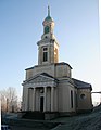
- Evangelical Luther Church Oberfrohna : The foundation stone was laid in 1890, built in neo-Gothic style, church consecration in 1893. The 60 meter high church tower is the landmark of Oberfrohna and can be seen from afar.
- Catholic parish with the Church of the Immaculate Conception
- Evangelical Luther Church in Kellers
- Evangelical Johanniskirche Rußdorf
- Evangelical St. Galluskirche Kaufungen
- Evangelical St. Mauritius Church (New Church) Wolkenburg and Church of St. Georg and St. Moritz (Old Church) Wolkenburg
- Evangelical Free Church Congregation (Baptists) with the Christ Chapel
- Evangelical Free Church Congregation, the light of life, Christ in the center
- Regional church community with a parish hall
- Evangelical Alliance in Oberfrohna.

Evangelical town church Limbach
St. Mauritius Church in Wolkenburg

Luther Church Oberfrohna

St. Galluskirche Kaufungen
_Ev_Stadtkirche.jpg)


Culture

- Landscape, natural monument, memorials
- The Limbach-Oberfrohna zoo, founded in 1959, is located at the city park and adjacent to the Limbacher Teiche conservation area .
- Hanneloreneiche natural monument
- Memorial stone on the connecting road between Limbach and Hartmannsdorf near the Elzteich pond for the two communists Arno Förster and Max Tennler who were shot on March 10, 1933 while fleeing from SS men
- Memorial stone in the municipal forest of Oberfrohna behind the equestrian facility to the Polish slave laborer Leon Tobola, who was hanged here on April 16, 1941
- Memorial stone in the Rußdorf district for all victims of fascism
- Memorial in the municipal cemetery for the 70 Soviet prisoners of war buried there
- A grave with a plaque in the cemetery in the Wolkenburg district commemorates five Polish victims of forced labor.
- War memorials for those who fell in World War I and World War II at the Limbach cemetery, in front of the Rußdorf church, below the Pleißa church, at the Kändler cemetery, at the Bräunsdorf cemetery, at the Kaufungen cemetery and at the Wolkenburg cemetery
- War cemetery for the dead from the hospitals in Limbach
- War cemetery for the victims of the bombing of February 5, 1945 as well as the deceased of the Oberfrohna hospital
- Memorial stone and trees for the introduction of the Reformation and the commemoration of the introduction of the Reformation in the Hainstraße Oberfrohna
- Memorial stone for the local chronicler Horst Strohbach in front of the Oberfrohna school
- Memorial stone for the foundation of the city park
- Memorial stone for the organist Johannes Pache in the city park
- Memorial stone for the patron of the city park Ernst Rebske
- Memorial plaque for Fritz von Uhde in the Mauritius church in Wolkenburg
Economy and Infrastructure
Established businesses
Limbach-Oberfrohna has a long industrial tradition. The city is best known for its former textile industry . Heinrich Mauersberger developed the Malimo textile process in the city . The tradition of the textile industry is continued even after the fall of the Wall (e.g. Riedel Textil GmbH with more than 200 employees), but after the unification-related slumps the employment effect is well below the level of before 1989. The commercial tradition of the location is represented by new industries For example, by Continental Automotive GmbH (formerly Siemens VDO Automotive ), Aumann GmbH (formerly USK Karl Utz Sondermaschinen GmbH) and light industry companies such as Warema Sonnenschutztechnik, continued in other ways. Most of these companies or investors in the city settled in the newly created industrial and commercial areas in and around the city after the political, social and economic upheavals of 1989/1990 . This development was the result of the gradual abandonment of traditional factory locations spread across the city, which were no longer competitive after 1990 - in the course of the unification of the two German states and the collapse of the previous sales markets. The following industrial and commercial areas exist in the area of the twin city (status at the end of 2014):
- Industrial park east: more than 1,500 jobs, development from 1992, Limbach district
- Industrial area Pleißa-West: more than 200 jobs, development from 1993, Pleißa district
- Commercial area KÄNDERER An der Hopfendarre : more than 400 jobs, development from 1996, district KÄNDER
- WIMA industrial park : Development of a large industrial wasteland from 1999, Limbach district
- Business park south: more than 300 jobs, development from 2001, districts of Pleißa and Kellers
traffic
Road traffic
Limbach-Oberfrohna is affected to the south by the federal motorway 4 , the city can be reached via its own exit and the Wüstenbrand exit. Via the exits Chemnitz-Röhrsdorf and Hartmannsdorf, the city is connected to the federal autobahn 72 that runs past to the east . The north extension of the federal motorway 72 enables a fast connection in the direction of Leipzig through three construction sections approved in the years 2006-2013 . Furthermore, the Glauchau - Penig section of the regionally important federal highway 175 crosses the northwestern district of Wolkenburg-Kaufungen.
railroad
The Wittgensdorf – Limbach and Limbach – Oberfrohna railway lines running through the city were closed in 2000. The Limbach – Wüstenbrand railway line was shut down in 1950. On the Glauchau – Wechselburg line leading through the Wolkenburg district , traffic was suspended after the Mulde flood in 2002 .
As part of the Chemnitz model , Limbach-Oberfrohna is to be connected to the Chemnitz Stadtbahn via parts of the disused Wittgensdorf – Oberfrohna railway line. The plans of the cities of Limbach-Oberfrohna and Chemnitz have been planning a route via KÄNDER and Chemnitz-Röhrsdorf to Chemnitz-Zentrum since 2003 , but have not yet been specified. It is uncertain whether and when it will be commissioned; the long-term date 2019 is now considered unlikely. The cost of the project is estimated at around 90 million euros, of which 60 percent will be borne by the federal government, 25 percent by the Free State and 15 percent by the Central Saxony Transport Association. In July 2012 it became known that the German Regional Railway also wanted to examine the renewed railway operation between Oberfrohna and Kellers .
Transportation
Local public transport in the city of Limbach-Oberfrohna is operated by buses. Since December 11, 2005, the express bus route 526 has been running between Chemnitz , Limbach and Oberfrohna with three stops in Limbach-Oberfrohna and three more in downtown Chemnitz. A special feature is the route over the federal motorway 4 . In addition to other overland routes from Regiobus Mittelachsen GmbH and Regionalverkehr Erzgebirge GmbH, minibuses (called Citybus ) from Fritzsche GmbH also operate on two city routes. With a view to a possible implementation of the Chemnitz model, Fritzsche GmbH is currently planning the option of a central bus station in Limbach-Oberfrohna.
education
There are a number of different educational institutions in Limbach-Oberfrohna.
Elementary schools
High schools and high schools
|
Other facilities
|
Personalities
sons and daughters of the town
- Kunz von Kauffungen (around 1410 - 1455), known for the Altenburg prince robbery
- Hans Haubold von Einsiedel (1654–1700), Electoral Saxon court official, Royal Polish and Electoral Saxon Chamberlain, Marshal of the Elector Prince, Chief Steward of the widowed Queen-Electress Anna Sophie and Privy Councilor in Dresden
- Hannibal Germanus von Schmertzing (1660–1715), Royal Polish Chamberlain and Elector of Saxony
- Karl Graf von Einsiedel (1770–1841), German diplomat
- Detlev Graf von Einsiedel (1773–1861), Saxon cabinet minister
- Robert Otto Gilbert (1808-1891), Protestant theologian
- Fritz von Uhde (1848–1911), painter
- Georg Heinrich Wahle (1854–1934), German legal scholar
- Arthur Esche (1857–1940), professor and member of the Reichstag
- Georg Wünschmann (1868–1937), architect
- Karl Poser (1870–1916), architect
- Karl Fritzsching (1891–1976), teacher, local researcher, monument conservator and draftsman
- Gottfried Grote (1903–1976), church musician, director of the Berlin State and Cathedral Choir
- Herbert Köhler (1906–1982), dialect poet of the Saxon Vorerzgebirge
- Lothar Green (1908-1981), football referee
- Heinz Kapitän (1915–1973), football player
- Ruth Bickelhaupt (* 1921), actress
- Hans Walther (1921–2015), name researcher
- Christian Doehler (1924-2004), journalist
- Helmut Kandziora (1925–2016), football player
- Werner Baumgart (1927–2009), jazz musician
- Werner Mittenzwei (1927–2014), theater and literary scholar, Brecht researcher
- Siegfried Schnabl (1927–2015), sexologist and psychotherapist
- Frank Vogel (1929–1999), film director and screenwriter
- Harald Thomasius (1929–2017), forest scientist
- Egon Kunze (1930–2010), chemist, university professor
- Gert Hofmann (1931–1993), writer
- Hilmar Ahnert (* 1936), football player
- Gerald Wolf (* 1943), biologist and physician, brain researcher, novelist
- Siegfried Gottwald (1943–2015), mathematician, logician and historian of science
- Christian Becher (1943–2013), cabaret artist
- Elke Hopfe (* 1945), draftsman and professor in Dresden
- Thomas Ziegler (1947–2014), painter
- Bernhard Ritter (* 1950), Member of the State Parliament (CDU)
- Jürgen Fanghänel (* 1951), amateur boxer, eight-time GDR champion
- Konrad Felber (* 1953), member of the Bundestag (FDP), member of the last people's chamber
- Matthias Müller (* 1953), former CEO of Volkswagen AG
- Falko Weißpflog (* 1954), ski jumper, GDR champion
- Stefan Stiegler (* 1954), Baptist theologian
- Rommy Arndt (* 1967 in Kändler), television and radio presenter
Personalities who have worked on site
- Detlev Carl Graf von Einsiedel (1737–1810), Saxon cabinet minister and company founder; 1760–1810 he made significant structural changes to Wolkenburg Castle. During this time, the castle park was redesigned in the English style and several Lauchhammer iron art cast sculptures were placed in the park.
- Johann Esche (1682–1752) is considered to be the founder of the West Saxon knitted goods industry
- Heinrich Mauersberger (1909–1982), inventor of the Malimo sewing technique
- Günter Reichelt (* 1957), wrestler, eight-time GDR champion, vice world champion 1983, national coach, grew up in Limbach-Oberfrohna
- Rudolph von Schmertzing (1591–1646), electoral Saxon major and war commissioner, owner of the Limbach manor
- Helena Dorothea von Schönberg (1729–1799), put on the first planned stocking-weaver settlements in Saxony
- Alfred Stier (1880–1967), composer and music director of the Evangelical Lutheran Church in Saxony
- Hermann Heinz Wille (1923–2002), writer
- Gustav Willkomm (1839–1910), founder and director of the world's first technical school for hosiery
literature
- The Limbacher Land (= values of the German homeland . Volume 5). 1st edition. Akademie Verlag, Berlin 1962.
- Author community: Limbach-Oberfrohna then and now - pictures from the development of our city Bildverlag Böttger, 1992.
- Author community: Limbach-Oberfrohna - Day of Saxony 2016. Sächsische Heimatblätter 62 (2016) 3, special issue of the Sächsische Heimatblätter with articles on the history and geography of Limbach-Oberfrohna
- Jürgen Sorge, Thomas Böttger: Limbach-Oberfrohna and its districts: published on the occasion of 125 years of Limbach municipal law, Bildverlag Böttger GbR, Witzschdorf 2008. ISBN 978-3-937496-24-5 .
- Without author: "The district of Chemnitz in historical views", Geiger Verlag Horb am Neckar, 1992, ISBN 3-89264-730-5 (for the history of the places in the district: Limbach-Oberfrohna with its districts Limbach, Oberfrohna and Rußdorf p. 22 –43, Fig. Rittergut Limbach p. 27)
Web links
- Official website
- Limbach-Oberfrohna in the Digital Historical Directory of Saxony
- Literature about Limbach-Oberfrohna in the Saxon Bibliography
Individual evidence
- ↑ Population of the Free State of Saxony by municipalities on December 31, 2019 ( help on this ).
- ↑ limbach-oberfrohna.de: data and facts , accessed on August 4, 2016
- ↑ a b Municipalities 1994 and their changes since January 1, 1948 in the new federal states , Metzler-Poeschel publishing house, Stuttgart, 1995, ISBN 3-8246-0321-7 , publisher: Federal Statistical Office
- ↑ www.reichstagsprotlog.de: Map with the exchange areas , accessed on September 19, 2010
- ↑ limbach-oberfrohna.de: history and interesting facts about our districts - Russdorf , accessed 2 September 2010
- ↑ a b StBA: Changes in the municipalities in Germany, see 1999
- ↑ statistik.sachsen.de: Municipal statistics 1999 for Limbach-Oberfrohna, city (area status January 1, 1999)
- ^ StBA: Changes in the municipalities in Germany, see 2000
- ^ Website of the Flossenbürg Concentration Camp Memorial Accessed July 6, 2016
- ^ StBA: Changes in the municipalities in Germany, see 1998
- ↑ Facebook entry on the pioneer camp
- ↑ Granting of rights in the regional register of Saxony
- ↑ Meinsdorfers flirt with their neighbors
- ↑ World record attempt succeeded ( Memento of the original from September 13, 2016 in the Internet Archive ) Info: The archive link was inserted automatically and has not yet been checked. Please check the original and archive link according to the instructions and then remove this notice.
- ↑ Saxony statistics on local elections 2019
- ↑ Final election results for City Council Limbach-Oberfrohna
- ↑ http://www.limbach-oberfrohna.de/limbach/module/pressespiegel/uploads/berichte/Stadtspiegel%2013-15.pdf
- ↑ Event in L.-O. in 2011 with mention of the then mayor. , accessed on August 18, 2018.
- ↑ Overview with a short history of all churches in L.-O. on a private homepage; accessed on August 26, 2018.
- ^ History of NOON GmbH (formerly Riedel Textil GmbH). Retrieved November 27, 2017 .
- ↑ limbach-oberfrohna.de: Business parks in Limbach-Oberfrohna
- ↑ Stadtspiegel - Official Gazette of the large district town Limbach-Oberfrohna, May 10, 2012 (PDF; 3.8 MB)
- ↑ Christian Mathea: Chemnitz should do more for rail. Start of the expansion of the Chemnitz model to Limbach-Oberfrohna uncertain. In: Free Press . Chemnitzer Verlag , November 8, 2012, accessed on November 9, 2012 .
- ↑ The train should go to Oberfrohna . Freiepresse.de. February 8, 2010. Retrieved May 14, 2010.
- ↑ Free press: Limbach-Oberfrohna: Company wants to reactivate rail
- ↑ With the shuttle bus from the front door to the arena . Freiepresse.de. June 16, 2010. Retrieved June 20, 2010.
Bräunsdorf | Trader | Limbach | Oberfrohna | Pleißa | Russdorf | Wolkenburg-Kaufungen (with Dürrengerbisdorf , Herrnsdorf , Kaufungen , Uhlsdorf with Mühlwiese , Wolkenburg / Mulde )