
Chemnitz center
 district and statistical district No. 01 of Chemnitz |
|
|---|---|
 |
|
| Coordinates | 50 ° 50 ′ 5 " N , 12 ° 55 ′ 17" E |
| surface | 3.17 km² |
| Residents | 11,823 (Dec. 31, 2013) |
| Population density | 3730 inhabitants / km² |
| Post Code | 09111, 09112, 09113, 09119 |
| prefix | 0371 |
| Transport links | |
| Federal road |
|
| tram | 1, 2, 4, 5, 6, 522 |
| bus | 21, 22, 23, 31, 32, 51, 62, 72, 76, N11, N12, N13, N14, N15, N16, N17, N18, regional bus routes |
The center is the centrally located district of the city of Chemnitz , which extends over the entire city center. It is delimited by the Chemnitz river of the same name in the west, by August-Bebel-Straße and Müllerstraße in the north, Dresdner Straße and Bahnhofsstraße in the east, the railway lines to Zwickau and Stollberg and by Falkeplatz in the south.
Downtown
In the center of the district there are some historical buildings such as the old and the new town hall on the market as well as the red tower (part of the old, long demolished city wall). The Jakobikirche is the oldest sacred building in the city, which, together with the high tower, adjoins the town hall ensemble. They are lined with numerous department stores and shopping malls. In addition, the area of the city hall with the city hall park, the 26-story “Mercure Kongress Hotel”, which opened as the Interhotel in 1971 and became the fourth largest hotel in the GDR at the time, and the Karl Marx Monument , the city's landmark, which was inaugurated in the same year , be mentioned. The inner city is bounded by busy streets which together form a ring road.
As part of the socialist reconstruction program in the 1960s, prefabricated apartments were built in the city center, as well as many buildings characterized by socialist architecture, which are currently being gutted and renovated. Many buildings that had survived the bombing of 1945 now had to give way to a new inner city suitable for the “working people” of “Karl-Marx-Stadt”. For example the “St. Pauli ”church, the“ Haus des Handwerks ”(with the“ Café Bienenstock ”), the“ Reichsbank ”, the“ Hotel Herrmann ”and“ Hotel am Friedrichplatz ”(the former“ Christian Hospiz Marthaheim ”), the buildings on the Outer Johannisstrasse and around the Johanniskirche as well as the southern Brühl district. Large parade grounds for the “working class” were to be created - an elevated street was also planned to lead around the city center.
The construction freeze in the mid-1970s in favor of the " Fritz Heckert residential area " turned Chemnitz into a wasteland. Only the " Rosenhof " (a street between the former Holzmarkt and Roßmarkt ), the Innere Klosterstraße and the so-called "Schuhmeile", completed in 1986, and the " Brühl ", which was renovated in the 1980s, invited you to stroll. Instead of a pulsating city center, a huge parking lot was created at the “Stadthalle” near the “Red Tower”. The historically grown roads also disappeared. The traffic junction was relocated from Johannisplatz (in GDR times “Posthof”) to the “central stop” opened in 1967 and the Posthof itself was created as a green oasis with a small pond with water plants, rock garden plants and a pergola with climbing plants.

The "Rosenhof" redesigned at the beginning of the new millennium
“Türmer” commercial building

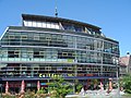
Red Tower Gallery
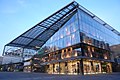
Glass department store

Panoramic view from the high-rise at Rosenhof

Aerial view of the city center of Chemnitz

Aerial view of the city center of Chemnitz
.jpg)


From the mid-1990s, the city center began to be given a new face by building new and modern buildings north and east of the market. For this purpose, some buildings that were only around 30 years old were demolished ("towers"). And also the residential building, which was only completed in 1986, with the “shoe mile” on the ground floor. One of the eye-catchers today is the glass department store of a well-known chain of department stores, which attracts attention at night with its play of colors. The former “Tietz” department store was also extensively renovated and transformed into the DAStietz cultural department store .
Brühl district

One of the city's first large-scale housing estates is located north of the city center, the Brühl (= swampy area). In contrast to the districts, this district has no fixed boundaries. The area can be narrowed down, so one speaks of the Brühl quarter of the area between Müller- and August-Bebel-Strasse in the north, Mühlenstrasse in the west, the Strasse der Kulturen in the east and Brückenstrasse in the south. The Brühl was an attractive residential and commercial area in the GDR era and even after the fall of the Wall. There were numerous shops as well as gastronomic and cultural facilities on the Brühl . After 1990, with the emergence of shopping centers in peripheral locations, the upgrading of the inner city since the end of the 1990s and a failed strategy by the municipal housing association, the area has lost a lot of its attractiveness. Attempts were made to deliberately empty the apartments and business premises, lettings in this area were stopped and the supply lines in the empty houses were cut. The aim was to sell the houses to investors. As a result, many apartments and almost all business premises were vacant. The investors stayed away, however. The city of Chemnitz has been planning to reactivate the Brühl as a residential area close to the city center for a long time . Serious efforts in this direction were also made in 2006. The first successes are already visible. Not only are apartments being rented again, but new individual shops have also been opened on Brühl-Boulevard.
history
The former village of Streitdorf , which belonged to the Blankenau lordship in 1318 , was once located on the site of today's Brühl district . With the purchase of land in 1402, it came to the city of Chemnitz. Over the years the village became desolate and gradually it disappeared completely from the maps, mostly through acts of war. Between the village and the city of Chemnitz there was also a large area (the Anger ) that was used as pastureland for cows and pigs - the names Kuh- and Sauanger arose from this. The land was also used for fish farming; the "linden ponds" were located below today's main train station for this purpose until 1840. There was also a brick factory here. The Anger , favored by the flat area in front of the city of Chemnitz, was also a parade area, parade ground and parade ground for the electoral troops. From the 17th century onwards, popular festivals took place here, for example the first balloon flight from Chemnitz on March 19, 1784. The annual Schützenfast was known beyond the city limits.
The Anger-Vorstadt was built on schedule from 1795 , and 117 houses were already here in 1822. To this end, the course of the Gablenzbach was changed in 1789 , which was spanned by several stone and wooden bridges - the Brückenstraße that developed here later still reminds of this today. By draining the "linden ponds" below the train station and backfilling the city moat, building land could be obtained for the expanding suburb.
The Brühl has had his name since 1836 , but at that time only the southern part, which had already been demolished, was built on. Friedrich was built in 1843 and Antonplatz in 1855 , which took the form of a small market square outside the city center. A market already existed on today's Theaterplatz , which has been called Neustädter Markt since 1861 and the Petrikirche was built on for the first time in 1888. Later, at the beginning of the 20th century, the König-Albert-Museum , the opera house and the Chemnitzer Hof were built here . The share spinning mill opened in 1860 on the northern edge of Schillerplatz was of economic importance . This square was named in 1859 on the occasion of the 100th birthday of Friedrich Schiller - it has been expanded as planned since 1890. At this time, construction work in the Brühl district ceased, although the city also moved further north - beyond the Zöllnerplatz , which was laid out in 1868 and named from 1881 onwards . On the western edge of the Brühl district there were several bathing establishments even before the Stadtbads opened in 1935 , such as the Schloßteich and Friedrichplatz .
The bombs from the attack on March 5, 1945 also hit parts of the Brühl district. In contrast to the hard-hit inner city, a large part of the old building has been preserved. The houses to the south and east of the Brühl had to give way to new buildings characterized by socialist architecture from the end of the 1960s. Between 1968 and 1979, for example, the party house, in front of which the Karl Marx Monument is located, and the Forum in 1978/1983 . The remaining part was partially restored from around 1980 and turned into a boulevard.
traffic

The street of the nations , which is a socialist shopping street and is an important artery, especially for public transport, runs right through the district . It connects the central stop with the main train station and the bus station at Schillerplatz by bus and tram . As part of the inner city renovation since 1995, this area was also renewed from 2004. The “central stop” was severely restricted in favor of the new “Kaufhof” building and outdated tram tracks were replaced in autumn 2005 to enable a connection to the northern parts of the city and the regions north of Chemnitz as part of the Chemnitz model .
The central stop of the Chemnitz trams is the hub of inner-city traffic and connects tram lines 2, 3, 4, 5, 6 and the national tram C13 of the Chemnitz City Railway to Stollberg .
See also
literature
- Udo Lindner and Karl-Joachim Beuchel: Chemnitz - Pictures of a New City. Chemnitzer Verlag 2005, ISBN 3-937025-15-4 .
- Udo Lindner: Chemnitz, Karl-Marx-Stadt and back. Chemnitzer Verlag 2002, ISBN 3-928678-73-6 .
Individual evidence
- ↑ Klaus-Dieter Seifert: The Chemnitz Academy and its Airplanes 1910 - 1945 , NoRa - Berlin, Aug. 2011, ISBN 978-3-86557-271-4 .
Web links

Districts: Adelsberg | Altchemnitz | Altendorf | Bernsdorf | Borna-Heinersdorf | Ebersdorf | Erfenschlag | Furth | Gablenz | Glösa-Draisdorf | Harthau | Helbersdorf | Hilbersdorf | Hat wood | Kapellenberg | Kappel | Kassberg | Lutherviertel | Markersdorf | Morgenleite | Rabenstein | Reichenbrand | Reichenhain | Rottluff | Chemnitz Castle | Schönau | Siegmar | Sonnenberg | Stilt village | Yorck area | center
Locations: Einsiedel | Euba | Grüna | Klaffenbach | Kleinolbersdorf-Altenhain | Mittelbach | Röhrsdorf | Wittgensdorf
Districts in localities: Berbisdorf | Murschnitz