Federal Highway 169

from Wikipedia, the free encyclopedia
Template: Infobox high-ranking street / Maintenance / DE-B
Federal highway 169 in Germany
Federal Highway 169
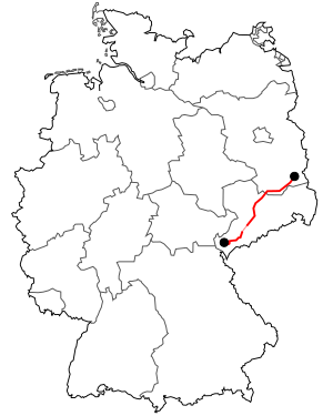
map
Course of the B 169
Basic data
Operator: GermanyGermany Federal Republic of Germany
Start of the street: Neuensalz
( 50 ° 30 ′  N , 12 ° 13 ′  E )
End of street: Cottbus
( 51 ° 44 ′  N , 14 ° 20 ′  E )
Overall length: 257 km

State :

Development condition: two-lane
Course of the road
Free State of Saxony
Vogtland district
Locality Neuensalz B173
crossing with large friezes S 312
Locality Neuensalz OT Mechelgrün
Locality Bergen S 301
flow 3 × shoot
Locality Falkenstein / Vogtl. OT drive
Locality Neustadt / Vogtl. OT Siebenhitz
Locality Falkenstein / Vogtl. S 298  S 303  S 304
flow Göltzsch
Locality Ellefeld
flow Göltzsch
Locality Auerbach / Vogtl. S 278  S 300
Locality Rodewisch S 280B94 
flow Göltzsch
Locality Steinberg OT Wernesgrün
Locality Steinberg OT Rothenkirchen S 277
Erzgebirgskreis
Locality Column green
Locality Schneeberg OT Neustädtel S 274
Locality Schneeberg (Ore Mountains) B93
Locality Bad Schlema
flow Zwickauer Mulde
Locality Aue (Saxony) B101 B283
Railroad Crossing Chemnitz – Adorf railway line
Locality Loessnitz (Ore Mountains)
Locality Lößnitz OT Affalter S 283
Locality Stollberg / Erzgeb. S 258B180 
Junction (13)  Stollberg-West A72 E441
Autobahn beginning replaced by A72 E441
node (15)  Chemnitz-South A72 E441
Template: AB / Maintenance / Empty together with B173through Chemnitz
Locality Stilt village
Locality Helbersdorf
Locality Chapel
Locality Kapellenberg
Locality center B95
flow Chemnitz
Locality Sonnenberg S 236B174 
Template: AB / Maintenance / Empty Symbol: tourist Chemnitz Central Station
crossing August-Bebel-Strasse B107
Template: AB / Maintenance / Empty together with B173through Chemnitz
Locality Hilbersdorf B173
Template: AB / Maintenance / Empty Symbol: tourist Saxon Railway Museum
Village end End of Chemnitz
Bypass Chemnitz-Ebersdorf bypass  S 238  S 200
Central Saxony district
flow Zschopau
Locality Frankenberg / Sa. S 202 S 203 S 204B180   
Junction (72)  Frankenberg / Sa. A4 E40
Locality Frankenberg OT Dittersbach
Locality Hainichen OT Gersdorf
Locality Hainichen OT Falkenau S 201
crossing Hainichen industrial area S 201
( for )A4 E40Symbol: truck stop
bridge under A4 E40
Locality Hainichen OT Schlegel
Locality Striegistal OT Arnsdorf
Locality Rossau OT Greifendorf
Confluence P. 36
crossing Roßwein OT Littdorf - Roßwein OT Otzdorf
Locality Waldheim OT Heyda S 32
Confluence Döbeln OT Ebersbach
Confluence Döbeln OT Neudorf S 32
Motorway junction Döbeln -Mastener StrasseB175
flow Freiberg Mulde
Motorway junction Döbeln-Zschepplitzer Strasse S 34
crossing Döbeln OT Gärtitz - GWG Mockritz / Großweitzschen
Confluence Mockritz / Großweitzschen industrial park Symbol: truck stop
Junction (34)  Döbeln-North A14
Bypass Ostrava bypass  S 35
Northern Saxony district
Locality Naundorf OT Salbitz S 30
Bypass Hof bypass 
Meißen district
Locality Upsetting S 33  S 86
Locality Stauchitz OT Plotitz
Locality Stauchitz OT Seerhausen
crossing B6
Template: AB / Maintenance / Empty interrupted by B6
Junction Seerhausen B6
Start of expressway Beginning of the motor road
Junction Riesa-Rostocker Strasse
Junction Riesa-Friedrich-List-Strasse
Junction Riesa-Bahnhofstrasse S 87B182 
Template: AB / Maintenance / Empty Symbol: tourist Riesa train station
flow Elbe ( Riesa bridge 365 m)
Expressway end End of the highway
crossing Zeithain OT Bobersen
crossing Zeithain OT Röderau S 88
Start of expressway Beginning of the motor road
Junction Nünchritz S 88
Junction Zeithain B98
Expressway end End of the highway
crossing Symbol: tourist Zeithain Memorial Grove
Locality Wülknitz OT Lichtensee S 89
Locality Wülknitz OT Tiefenau
Railroad Crossing Zeithain – Elsterwerda railway line
Locality Gröditz S 90
flow Big Röder
State of Brandenburg
Elbe-Elster district
flow Elsterwerda-Grödel raft canal
Locality Röderland OT Prösen
Railroad Crossing Berlin – Dresden railway line
crossing at RöderlandB101
flow Pulsnitz
flow Black magpie
Locality Elsterwerda L 62B101 
Locality Plessa L 621
Oberspreewald-Lausitz district
Bypass Lauchhammer L 63 bypass 
Junction (17)  Ruhland A13 E55
crossing at Ruhland L 55
Locality Schwarzheide
Bypass Senftenberg L 60 bypass B96 
Template: AB / Maintenance / Empty together with B96direction Allmosen
flow Rainitza
Locality Senftenberg OT Sedlitz
crossing B156
Template: AB / Maintenance / Empty together with B96direction Senftenberg
crossing at almosesB96
Locality Alms
Bypass Allmosen bypass
Locality New Zealand OT Lindchen L 531
Locality Neupetershain -Nord L 522
Spree-Neisse district
Bypass Drebkau L 52 bypass 
Locality Drebkau OT Klein Oßnig
Locality Kolkwitz OT Klein Gaglow L 50
Junction (4)  Cottbus-West A15 E36
Independent city of Cottbus
Locality beginning Entrance to  Cottbus
Street as Hermann-Löns-Straße
Street as Dresdner Strasse
Street as a city ring
Village end End of town Cottbus
Junction B168
  • Under construction
  • In planning
  • Traffic control system
  • The federal highway 169 (abbreviation: B 169 ) is a German federal highway in Brandenburg and in the Free State of Saxony .

    history

    origin

    The section between Chemnitz and Stollberg was expanded into a Chaussee in 1823 .

    Previous routes and names

    The national highway 169 between Cottbus and Plauen Small Friesen was introduced to the 1937th It led from Plauen Kleinfriesen over Großfriesen and met the current route at the so-called Dreckschenke. From Neuensalz was rebuilt in the GDR. Construction plan documents show that construction work was carried out in the early 1970s. In the GDR it was referred to as main road 169 (abbreviation F 169 ).

    Gradations

    With effect from January 1, 2016, the section between the A 72 motorway junction in Niederdorf and the federal highway 173 Südring Chemnitz was downgraded to the state roads 257 and 258.

    expansion

    Saxony

    The B 169 is currently being expanded in the second section in the Riesa / Döbeln area. From the junction of the B 6 in Seerhausen to the completed four-lane section in Riesa, it was expanded as the B 169n and opened to traffic on September 24, 2012. The European Regional Development Fund contributed 20 million euros to the costs.

    According to the Saxon state government, the further expansion is to be carried out up to the junction A 14 Döbeln Nord. The project in particular serves to create an efficient road connection between the city of Riesa and the federal motorway 14 north of Döbeln. In this area, it will relieve traffic in the Salbitz and Seerhausen locations. Through the implementation, the current noise and pollution will be eliminated, based on the traffic occupancy with a high proportion of heavy traffic for the residents, which is associated with an improvement in the quality of life. The travel time is also shortened considerably as there is no need to drive through town. For the expansion between Seerhausen and Döbeln several approval procedures and decisions from the neighboring communities about the route variants of the B 169 are still required.

    Since 2013, the "Göltzschtal bypass" has been under construction to re-route the B 169 between Rodewisch and Siebenhitz (Neustadt / Vogtl.) . The work should be completed in 2018, but the opening was postponed to 2021 due to contaminated sites.

    Brandenburg

    Currently, the partially three-lane expansion of the B 169 between the Ruhland and Plessa motorway junction to form a motor vehicle is in planning. According to the current state of knowledge, the 14.5 kilometer long new construction with several bridges is to begin in two stages from 2017/2018 [obsolete] . The B 169 represents a nationally important east-west route between Cottbus and the Elbe-Elster district and has a high proportion of traffic in the south of the country.

    The regional planning procedure (ROV) for the OU Elsterwerda in the area of ​​the B 169 was opened on January 4, 2010.

    The estimated construction costs currently amount to 32.5 million euros.

    additional

    The B 169 runs as a route through Niederlausitz across the whole of Niederlausitz . Of the total length of 257 kilometers, around 30 kilometers have been expanded into four lanes. Partly the federal highway 169 runs on the same route with other federal highways, such as the B 96 .

    The Erzgebirge folk rock singer and songwriter Stefan Gerlach dedicated the song “De 169” (published in 1994) to the street that leads through his home town of Stützengrün .

    See also

    Web links

    Commons : Bundesstrasse 169  - Collection of pictures, videos and audio files

    Individual evidence

    1. in Chemnitz partly four-lane; Senftenberg bypass with three lanes; Riesa and Zeithain bypass with four lanes similar to a motorway
    2. Saxon. Official Journal 48/2015. S1641 ff.
    3. Axel Kaminski: New B 169 between Riesa and Seerhausen free for traffic. In: OAZ Online . September 24, 2012, accessed December 4, 2018 .
    4. Approvals EU Commission. (PDF, 2 MB) In: verNETZt - Information brochure on the Operational Program for Transport EFRE Federal Government 2007–2013, December 2 , 2011, p. 1 , archived from the original on November 10, 2013 ; accessed on December 4, 2018 .
    5. Daniel Seifert: Göltzschtal bypass will be passable from Siebenhitz to Rodewisch in 2018. (PDF, 11.5 MB) In: Vogtland district journal. August 26, 2015, pp. 1, 8 , accessed December 4, 2018 .
    6. Construction of the Göltzschtal bypass is not getting anywhere. In: Free Press. December 15, 2018, accessed September 3, 2019 .
    7. B 169 expansion not consistently three-lane. In: LR Online . January 22, 2014, accessed December 4, 2018 .