
Junction (motorway)


A junction (symbol in Germany ![]() :, abbreviation AS, in Austria ASt ) is a junction that is at least unplanned to the autobahn , and largely devoid of plan , which connects autobahns with the subordinate road network. The term is also used for other roads with no intersections , such as motorways (motorway-like roads, expressways) , or sections such as bypasses or tunnels .
:, abbreviation AS, in Austria ASt ) is a junction that is at least unplanned to the autobahn , and largely devoid of plan , which connects autobahns with the subordinate road network. The term is also used for other roads with no intersections , such as motorways (motorway-like roads, expressways) , or sections such as bypasses or tunnels .
A junction as a connection to the high-level road network improves the transport infrastructure of an area and is therefore an important location factor for the economy . It consists of a driveway ( freeway entrance ), also called an entrance ( freeway entrance ), and an exit ( freeway exit ), also known as an exit ( freeway exit ), on both lanes and is designed in such a way that the flowing traffic on the freeway is not impaired. In addition, there is a deceleration lane next to the motorway at the exit , which enables the departing vehicles to reduce their speed in order to drive safely through the exit. When approaching, an acceleration lane is used to reach the speed driven on the freeway so that vehicles can get into the flow of traffic. Deceleration and acceleration lanes are separated from the motorway by lane markings . In construction site areas and densely built-up areas, acceleration and deceleration lanes can be extremely shortened or even omitted entirely.
Designations
|
|
In Switzerland, the names for a motorway entrance are motorway entrance (such as French entrée / Italian entrata ), the departure corresponding to exit (such as French sortie / Italian uscita ). In Switzerland, the term ascent refers to the Christian holiday of Ascension , descent a discipline in skiing or the time of departure (e.g. on the train).
Naming and numbering
Junction points are usually named after a nearby location that can be reached via them (not necessarily the closest structurally), and occasionally also after connected regions.
In addition, each connection point is assigned a number, which makes it easier for drivers who are not familiar with the area or language to find their way.
In Switzerland and Germany , every junction has a sequential number (relative numbering), which normally starts with 1 for every motorway, including motorway junctions and motorway triangles . In the case of double junctions or junctions within a junction , a common number can also be assigned for several exits. If another junction is set up between two existing junctions, the numbering will be extended with subsequent letters (e.g. 23 - 24a - 24b - 25 on the A 27 between Achim and Verden).
In Austria , Slovakia , the Czech Republic , Hungary and other countries, on the other hand, the exit number corresponds to the current kilometer of the motorway at the junction (absolute numbering). This has the advantage that, as a user, the number of the junction and the official motorway mileage are constantly informed about the status of the distances covered / to be covered, and the numbering scheme for junction points set up at a later date does not have to be adjusted or expanded.
Designs
There are different types of connection points, which can vary depending on the topographical conditions and the volume of traffic. Most of the time, the motorway feeder leads over a bridge over the motorway, which is the more energy-efficient variant for vehicles. Especially in densely built-up areas, the motorway sometimes leads over the feeder road. The exits are usually on the right-hand side of the road, even if the exit leads to a road that runs to the left. There are only a few interchanges in Germany that lead to the left . The choice of design includes construction costs ( land consumption , asphalt and bridge area), traffic safety and capacity (traffic volumes per direction), as well as the waiting and driving time per vehicle and the associated economic and environmental balance as well as operating costs such as the life of the asphalt and operation and the maintenance of traffic lights . The types of interchanges that occur in Germany are dominated by those where three traffic directions are in conflict. The performance of the feeder is accordingly affected.
In metropolitan areas there are occasionally junction points that only allow driving up or down in one direction. Often there are different types of driveway and driveway on the two directional lanes. These are half and incomplete connection points, so-called partial connection points .


Parallel ramps
The descent is before crossing the feeder road. On the other side of the street the driveway leads to the motorway. This creates two crossings, each with a one-way street on the feeder.

This type of construction is often used where the area next to the motorway does not allow extensive expansion. If the entrances and exits run very close and almost parallel to the higher-level street, this design is also called "Dutch ramps" or, in the Anglo-Saxon language, "diamond" because of the shape of a "diamond". "Rhombus" is the designation in the RAA 2008. In Germany they appear on the B 10 between Stuttgart-Wangen and Esslingen . A particularly narrow and steep variation of the Dutch ramp is found at the exit Oberlinxweiler of B 41 , real Dutch ramps are in the east of Rotterdam be found on the A 20 for Capelseweg: 51 ° 57 '21 " N , 4 ° 33' 45" O . In the USA, this design is known by traffic engineers as the English Tight Urban Diamond Interchange (TUDI for short) and precisely defines the design with Dutch ramps running close to the autobahn in connection with two traffic light-controlled four-armed intersections on the feeder.
For safety reasons, ramps are avoided wherever possible, as the feeling for speed is lost on long and fast journeys and the view of the ramp opposite suggests a route. Road users are made aware of their actual speed again through curves.
In addition, u. a. in the USA and Denmark the ramps are partly about 100 m away from the motorway. One of the reasons for this is that the motorway can be widened and indirect ramps , also known as “ears” or “loop ramps ”, can be built in to relieve the feeder road. The connection points with indirect ramps are clover leaves (partial clover leaf ). Another effect of the removed ramps is the lengthening of the route between the intersections on the feeder. This extends the driving time of the vehicles between the two intersections and, depending on the load in each direction, affects the overall performance of the node. This affects through traffic on the feeder road that does not use the motorway.
The width of the ramps has an impact on the type of bridge: With a TUDI (narrow diamond), the left-turning lanes are arranged in parallel, which means that they have to be placed on the bridge, which must consist of four lanes. TUDIs in Germany can be found on Munich's city highways .
If the ends of the ramp are a little further away from the motorway, the bridge becomes three lanes, as the left-turning lanes are one behind the other. For very wide ramps, a two-lane bridge may be sufficient if the left-turn lanes outside the overpass are sufficiently long.
Contra Flow Left Turn
In Florida, a special form of TUDI can be found in which the left-turners are collected in front of the first feeder intersection and are led over the bridge to the left of the left-turners of the oncoming traffic. This design is referred to as "Contra Flow Left Turn" (CFL) and the Lyons Creek Parkway to Sawgrass Expressway (FL 869) at 26 ° 18 '4 " N , 80 ° 11' 11" W to be found. CFL enables an original TUDI to make a tangential left turn as in the SPUI.
Michigan Urban Diamond Interchange
In order to make the feeder more efficient, the Michigan Left was also integrated into a junction called the Michigan Urban Diamond Interchange (MUDI) or Median U-Turn Interchange (MUT). This requires two more bridges for the turning ramps. One example is on the interstate 696, the Walter P. Reuther Freeway in Southfield (Michigan) at 42 ° 29 '14.5 " N , 83 ° 14' 28.3" W . In the Italian Foligno are at Strada Statale Flaminia three-armed MUDI at 42 ° 57 '6.3 " N , 12 ° 43' 20.4" O .

Third entrance (5 ramps)

Third exit (5 ramps)

Tight Urban Diamond Interchange (TUDI)

ContraFlow Left Turn Interchange (CFL)

Tight diamond with turning ramps (Texas U-Turn)

Diamond with continuous flow


Split diamond
The “Split Diamond Interchange” can be roughly referred to as a “split diamond”. It is based on the Town Center Intersection, which is based on the Split Intersection and in which the roadways of the feeder road that are divided at a certain distance intersect with the ramps and divide the original intersection into four intersections, which therefore only have two conflicts. A "split diamond" with two main directions is the three-tier diamond, also known as " volleyball ".
- 49 ° 28 ′ 53.8 ″ N , 11 ° 0 ′ 18.9 ″ E Frankenschnellweg AS Fürth-Poppenreuth (Poppenreuther Bridge)
- 49 ° 9 ′ 7.9 ″ N , 9 ° 11 ′ 59.7 ″ E Neckartalstrasse to theB 39in Heilbronn
- 50 ° 7 ′ 6.8 ″ N , 8 ° 43 ′ 52.2 ″ E A 661AS Frankfurt Ost toB 8in Frankfurt am Main
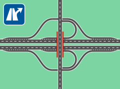
dumbbell
American traffic engineers speak of the English dumbbell intersection , the connection point in the form of a dumbbell . This corresponds to Dutch ramps with the difference that the intersections on the feeder with the ramp ends are replaced by roundabouts, which in the aerial view are arranged like the weights of a dumbbell. This type of construction occurs frequently in England, France, the Emirates, Spain and Italy, in Germany, the USA and Australia sporadically for new buildings and changes with smaller traffic volumes. In Germany, as an example, built in the 2010s years junction Waldkappel on the motorway 44 to call: 51 ° 8 '44 " N , 9 ° 55' 21" O . The roundabouts can connect other roads in addition to the feeder. The advantages of this variant are the lower operating costs. No traffic lights and thus no electricity connection are required and the asphalt of roundabouts has to be renewed less frequently than at a traffic light intersection. In the event of an overload, third ramps can be retrofitted on each side of the motorway, provided there is space, which enable the passing vehicles to pass through the roundabout less than 180 °. The expansion to turbo roundabouts is applied practice.
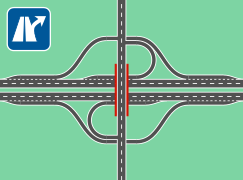
One or both roundabouts in the dumbbell can also be provided with additional up and down ramps to increase the capacity. A good example of such a “turbo dumbbell”, which was half a clover leaf before the L14n was built, can be found in Jülich ( 50 ° 54 ′ 51 ″ N , 6 ° 19 ′ 24 ″ E ).

Four
half-leaf clover ramps with roundabouts
Six ramps
Double ramps
Six ramps
Double exit ramps
Four ramps
paths and utilization in the roundabout (without through traffic of the feeder)
Six ramps
routes and utilization of the third ramp (yellow marking)


Dog bones
American traffic engineers speak of the English dogbone intersection , the connection point in the form of a dog bone. A simple needs analysis shows that the dumbbell does not need a full roundabout if only the feeder leads to the roundabout. The second teardrop-shaped roundabout offers the opportunity to turn around. If a large roundabout were to be built over the motorway, this would require a second bridge and thus increase costs. It is cheaper to deform the course of a roundabout so that it can be guided over a single bridge. The original roundabout becomes two teardrop-shaped roundabouts. A shape is created that resembles the lengthways diametrical cut of a red blood cell or bone . The performance of the connection point corresponds to the dumbbell. This variant is clearer for traffic leaving the motorway, as only traffic from the bridge has priority. This enables smaller roundabouts to be built without making a backlog on the motorway more likely. The roundabouts will be made passable for heavy haulage and extra-long vehicles. Top art is impractical here because of the size. An example is located on the Hauptstrasse 3 / 7 at the A2 / A3 port Birsfelden in Canton Basel Country at 47 ° 32 '52 " N , 7 ° 38' 1" O . In the Carmel suburb of Indianapolis , some of these junctions have been built along Keystone Parkway ( 39 ° 56 ′ 30 ″ N , 86 ° 6 ′ 47 ″ W ). A turbo dog bone is on the Dutch Burgemeester Elsenweg (A20) between Maasdijk and De Lier to Coldenhovelaan at 51 ° 57 '10 " N , 4 ° 13' 56" O . A mixture of dumbbell and dog bone is on the Dutch Beneluxweg (N7) to the connection point Gotenburgweg in Groningen at 53 ° 12 '53 " N , 6 ° 36' 9" O to find. In New Zealand , another of these hybrid forms can be found on the Auckland-Waiwera Motorway in Silverdale at 36 ° 37 ′ 31 ″ S , 174 ° 39 ′ 46 ″ E.

Diamond with an intersection (SPUI)


A precise name for this type of construction comes from American traffic engineers and also defines the part of the traffic junction at the same level: A Single Point Urban Interchange, SPUI for short (= literally: urban one-point connection ≈ one- point full connection point ), called “diamond with one intersection” in the RAA 2008 a set of traffic lights with long interim times and a single large intersection with no elevation to the motorway. The bridge over the motorway must be made wider for this. The power requirement for the traffic light system causes the word urban in the name, since a power connection is not necessarily available far away from inhabited areas. The construction is carried out on Dutch ramps, the ends of which branch off at the feeder into collectors for right and left turns from the motorway or line up the right turn into the left turn on the motorway. The feeder needs three signal directions on the traffic light system, whereby the right-turners are subordinated without a signal (under sign 205 ![]() ) and the left-turners drive tangentially in pairs by signal from or onto the motorway. The remaining traffic light phase serves the through traffic of the feeder.
) and the left-turners drive tangentially in pairs by signal from or onto the motorway. The remaining traffic light phase serves the through traffic of the feeder.
Wallace Hawkes, chief traffic engineer at J. E. Greiner Inc. (today: URS Corporation) is considered to be the forefather of SPUI. The first was on February 25, 1974 Clearwater (Florida) completed, USA and still connects the Interstate 19 with the Florida State Road 60 at 27 ° 57 '38 " N , 82 ° 43' 48" W . The tangential turning reduces the number of conflicts to 3. Since there is only one intersection within the traffic junction, the phases of the traffic light can be very long. While these junctions were newly built in the USA, some inner-city crossings were subsequently tunneled under in Germany, which meant that the ramps were already built-up and had to be serviced. Instead of bypassing a block , the fourth direction, straight ahead over the ramps, was set up parallel to the no-height direction.
In North Rhine-Westphalia, SPUIs are also used for motorway-like roads:
- The Wuppertal-Elberfeld junction of the A 46 . 51 ° 16 ′ 14 " N , 7 ° 9 ′ 17" E
- The junction of the B 56 to the B 484 . 50 ° 48'55 " N , 7 ° 12'18" E
- The junction of the A 52 to the B 227 , Essen-Berghausen. 51 ° 26 '25 " N , 7 ° 2' 10" E
- Also B 56 to B 8 , also in the urban area of Siegburg . 50 ° 48 ′ 39 " N , 7 ° 11 ′ 18" E
In the Nuremberg area, the following connection points and transport hubs are built like this:
- 49 ° 25 ′ 23 ″ N , 11 ° 2 ′ 16 ″ E Südwesttangente, AS Nürnberg-Schweinau to connect the B 2 and B 14
- 49 ° 26 ′ 19 ″ N , 11 ° 0 ′ 12 ″ E Südwesttangente, AS Nürnberg-Kleinreuth
- 49 ° 24 ′ 28 ″ N , 11 ° 4 ′ 15 ″ E Südwesttangente, A 73, AS Nürnberg-Hafen-Ost to Hafenstraße and Straße Finkenbrunn
- 49 ° 24 ′ 27 ″ N , 11 ° 3 ′ 4 ″ E Frankenschnellweg, AS Nürnberg-Eibach
- 49 ° 25 ′ 42 ″ N , 11 ° 3 ′ 48 ″ E Frankenschnellweg, AS Nürnberg-Südring (Otto-Brenner-Brücke, intersection with B 4R)
- 49 ° 27 '6 " N , 11 ° 2' 17" O Frankenschnellweg, AS Nürnberg-West ring (Jansen bridge crossing with B 4R)
- 49 ° 27 ′ 23 ″ N , 10 ° 58 ′ 33 ″ E southwest tangent, AS Zirndorf
In Baden-Württemberg, those turning right on the SPUI are always under traffic lights:
- In Heilbronn the L 1100 (Bridge Street and Karl-Wuest road) in this manner at the K 9562 49 ° 10 '8 " N , 9 ° 12' 16" O connected, which is rare in Baden-Württemberg.
- In Stuttgart, the intersection of the B 14 and B 27 in the further course of the B 14 is built two more times as SPUI.
- In Ludwigsburg, the B 27 runs once as a feeder (to the L 1140) and as a vein (to Wilhelmstrasse) via a SPUI. Since the ramps are conventionally used roads, in the latter example the fourth direction was retained for the straight-ahead traffic, which leads to longer waiting times. The remaining intersections are at the same height and are the cause of the daily traffic jam.
- Sindelfingen , on the L 1185 Hanns-Martin-Schleyer-Straße to Rudolf-Diesel-Straße
- Karlsruhe , on the B 10
- Ulm , on the B 28
Berlin
- A100, exit Hohenzollerndamm
Other SPUIs:
- Several junctions on the A 40 , A 42 and A 44 motorways
- The junctions ⊙ Hammer Straße and ⊙ Albersloher Weg of the B 51 in the city of Münster .
- All junctions of the B17 in Augsburg from Oberhausen-Süd to Eichleitnerstraße, except Stadtbergen and Leitershofer Straße.
Special SPUIs:
- A double SPUI on the A 113 is SchönefeldWaltersdorf south 52 ° 23 '50 " N , 13 ° 31' 8" O and 52 ° 23 '34 " N , 13 ° 31' 23" O .
- A one-point half-junction is Duisburg-Buchholz (AS 14) on the A 59 at 51 ° 23 '0 " N , 6 ° 46' 28" O .

Inverted SPUI
The "Inverted SPUI" (inverted single-point full connection point) is a modification of the SPUI that rarely occurs in the USA, in which bridge space is saved. The feeder crossing will be relocated from the bridge between the lanes of the motorway and the ramps on the motorway will be connected on the left.
In Greensboro (North Carolina) an inverted SPUI is located on the West Wendover Avenue to South Holden Road at 36 ° 3 ' "53 N , 53 79 ° 50'" W . In Tulsa , Oklahoma, there are additional interchanges on Interstate 244 at Sheridan Road 36 ° 9 ′ 48 ″ N , 95 ° 54 ′ 16 ″ W, and North Memorial Drive at 36 ° 9 ′ 44 ″ N , 95 ° 53 ′ 13 ″ W of this type, as well on the South Harlem Avenue, Chicago , Illinois to Interstate 290 41 ° 52 '25 " N , 87 ° 48' 16" W .
Three arms is at Ohio State Route 7 to Interstate 470 at 40 ° 2 '52 " N , 80 ° 44' 1" W to be found.
Hybrid forms are 36 ° 9 ′ 43 " N , 95 ° 59 ′ 31" W and Salt Lake City 40 ° 45 ′ 38 " N , 111 ° 54 ′ 51" W in Tulsa .

Offset SPUI
A rare and complex variant is the offset SPUI, in which the ramps in one direction of the motorway are led to the other side by bridge or tunnel in order to lead them to an intersection on the feeder road next to the motorway. This costly solution is suitable when there is little space or view on one side of the highway, or the feeder has another transportation hub nearby, the so node spheres of influence with the junction overlap. On the E Avenue Alameda to Interstate 225 in Aurora (Colorado) an offset SPUI was built, 39 ° 42 '40 " N , 104 ° 49' 33" W .
3-level SPUI
A three-level SPUI (three-level SPUI) has carried the feeder on a third floor level, only the turns have been taken out of free-flowing traffic. The feeder becomes the second main direction. At the remaining intersection, the left-turners are guided tangentially in pairs over a traffic light with two signal phases. Part of a three-storey SPUI is the Braddell Under pass to the Central Expressway (CTE) in Singapore in 1 ° 20 '36 " N , 103 ° 51' 37" O .
The busiest left turns at diamond on Jinxing Avenue (the major road) and Food City Avenue (Shi Pin Cheng Da Dao), in the Yubei District of Chongqing at 29 ° 39 ′ 36 ″ N , 106 ° 36 ′ 46 ″ E were about one Height-free ramp run as part of a third floor.

DDI / DCD

A certificate in France from the 1970s and from 2009 in the United States Renaissance experiencing and already established there interchanges design is the DDI - Diverging Diamond Interchange (≈ vice rolled diamond) or DCD - Double Crossover Diamond Interchange (= double-crossed diamond), the gross could be referred to as left-hand traffic diamond. In France , too , there is no official name; the term “pont à l'Anglaise” (= English-style bridge) is used.
The advantage of the DDI lies in its high level of transparency, since only two traffic directions have to be switched and no pre-sorting areas are required for turning, but can be installed to increase capacity. This traffic hub develops its greatest performance when the through traffic on the feeder is less than the exchange to the motorway. In this case and if an existing connection point is overloaded with Dutch ramps (if the traffic light goes around several times until the junction is passed), retrofitting the existing infrastructure can come into question.

Instead of the intersections at the ramp ends of the feeder, the directions of travel are swapped at the same height using traffic lights. In the resulting left-hand traffic , left-turners have the properties of right-turners and are free of crossings at the same level. This can make an anti-glare fence necessary. In addition to the intersections between right-hand and left-hand traffic, the ends of the ramps are branched. The exit branches off in the directions of the feeder, which can now be reached without any elevation. The approaching vehicles from both directions of the feeder line up in the entrance ramp. In principle, two directions are switched in the program of the traffic light system:
- Vehicles leaving the motorway and clearing the feeder bridge
- Vehicles entering the motorway from the feeder and collecting through traffic on the feeder.
Additional programs are also required:
- Pedestrian crossing (which involves a minimum travel time in one direction)
- Transparency for a feeder establishment with increased traffic
The actual signal cycle times are adjusted in proportion to the travel time between the two crossings in order to stop as few vehicles as possible. In order to become even more efficient when the workload is being carried out, the node should include monitoring of the backwater. The short protection times can be even shorter if it is ensured that the stopped direction is actually in place and the intersection has been cleared. If an attempt is made to regulate the entry ramps via light signals, the node needs collectors or rapidly loses capacity. Instead of collecting the approaching vehicles, it is cheaper to equip the ramps with this area for threading. A DDI often appears to be overloaded on still images, as vehicles in three directions wait together but less long. The only thing that has to be considered when driving through is the early selection of the lane, which is always arranged in the direction of the destination.
The magazine “Popular Science” reported among the “Best Innovations in 2009”. In the USA, Gilbert Chlewicki is considered the father of the DDI, but he had to find out that his idea had already been used in France in the 1970s.
- DDIs in France
- 48 ° 49 ′ 56 ″ N , 2 ° 9 ′ 10 ″ E inVersaillesonBoulevard de Jardyon the A 13Autoroute de Normandie
- 48 ° 49 ′ 49 ″ N , 2 ° 29 ′ 35 ″ E on the A4Autoroute de l'EstinChampigny-sur-Marne(Pont de Nogent)
- 50 ° 32 '41 " N , 3 ° 3' 21" O on the A 1 (E 17)Route du NordatSeclinto theRoute d'Avelin
- 48 ° 47 ′ 11 ″ N , 2 ° 13 ′ 22 ″ E on the N 118 near Meudon there is a similar traffic route, withroundaboutsover the same bridge structures.
- DDIs in the USA
- 37 ° 15 ′ 1 ″ N , 93 ° 18 ′ 39 ″ W onInterstate 44and the North Kansas Expressway (Missouri State Route 13) inSpringfield, Missouri. Construction began on January 12, 2009, and opened on June 21, 2009 It is the first DDI in the USA.
- 40 ° 25 ′ 53 ″ N , 111 ° 53 ′ 27 ″ W onInterstate 15and the Timpanogos Highway (Utah State Route 92). Utahopened its first DDI on August 15, 2011 as a conversion of the existing interchange.
- Since their introduction in 2009, over 60 DDIs had been completed in the USA by 2015, 89 were in operation in 2017 and over 100 in 2018. Most of them replaced an existing connection point.
- DDIs in Canada
- Canada's first DDI went live on August 14, 2017.
- DDIs in Denmark
- In 2015, Denmark's first DDI based on the American model was approved and went into operation on September 17, 2017 and is a conversion of the existing diamond on the E20 (Fynske Motorvej), junction 52 to Assesvej to Odense . 55 ° 21 '41 ″ N , 10 ° 20 ′ 42 ″ E After a simulation with PTV Vissim , the DDI turned out to be the most suitable conversion of the existing junction.
- DDIs in the United Emirates
- The first opened in May 2014 on 51st Street to E50 in Abu Dhabi.
- DDIs in Australia
- Australia's first DDI was planned for the Bruce Highway in Queensland to open by 2020.
- DDIs in South Africa
- N2 / R102 in Mount Moriah
- DDI in Lithuania
- At Kaunas , the clover leaf of the A1 and A6 is to be replaced by a DDI, the A6 is not free of height.
- DDI in Belgium
- The existing roundabout N4 / N25 at Louvain-la-Neuve will be converted into a DDI in 2019, known there as the “Indonesian junction”.

DCMI
In order to make the DDI even more efficient, it is advisable to design the two crossings with no heights. This is held as a patent by Michael A. Gingrich Sr. under the designation DCMI ( English Double Crossover Merging Interchange ) . There is little space, left-hand exits and three bridges are required on the feeder road. The length of the slope has a direct effect on the size. The height-free traffic junction is fully disentangled.

Half leaf clover
For a long time, the most common form in Central Europe is the half-leaf clover. Depending on the direction of travel, the entrance and exit run via the direct ramp as an S-curve from or onto the feeder road and the opposite direction via the indirect ramp as a curve to the acceleration lane or from the deceleration lane to the feeder. Both entrances and exits are on the same side of the feeder. This design is known as a folded diamond because the mouths of the ramps are shifted to the highway to the feeder. The advantage of this design is that the bridge can be used for other types of traffic at no height. This height-free direction can also be applied to the feeder. On South 1st Street to the US-277 Winters Freeway in Abilene (Texas) , the two branches of the feeder are designed as Seagull Intersection or Continuous-Green-T . 32 ° 27 ′ 8 ″ N , 99 ° 47 ′ 6 ″ W.

Half diagonal shamrock
This is the directionally symmetrical variant of the half-leaf clover, in which either the two exits or the entrances each run over a direct ramp. A distorted form of it arises when the feeder and the motorway intersect at an acute angle, as at the connection point Kenn of the A 602 , where the feeder, the L 145, runs parallel to the motorway. This can also be found on the B 29 at the junction to the L1157 east of Schwäbisch Gmünd in Baden-Württemberg, and in Bavaria at the Putzbrunn junction , which connects the B 471 to the A 99 .
How the four ramps are arranged depends not only on the topological conditions but also on the requirements. Turning right causes fewer conflicts in the respective node of the feeder.
The previous variants reduce the capacity of the feeder to less than half compared to an intersection-free road.

Six-ramp part shamrock
A third ramp is installed here in each direction of travel. Only two of the three directions on the feeder are now in conflict.
Junction with double entry ramps

43 ° 34 ′ 18 ″ N , 79 ° 47 ′ 24 ″ W
This design, which is still not very common in Germany, is the powerful and space-saving compromise between Dutch ramps and cloverleaf . It is referred to as the "six-ramp partial clover" or "¾" because it has six of eight ramps of a node that is completely free of elevations. It relieves the feeder by eliminating the left-turners and can be better integrated into a green wave with traffic lights , since only two directions have to be switched. It will, among other Canadian expressways in Toronto and on the (SR CA 118) Ronald Reagan Freeway at the level of Simi Valley used several times. In order to keep the traffic flowing on the motorway, flow control systems are switched on if necessary . It is most widespread in the USA, with a striking frequency in California.
In Germany u. a. on the A 94 the Feldkirchen-West junction 48 ° 8 ′ 31 ″ N , 11 ° 42 ′ 34 ″ E , on the A 99 the Munich-Ludwigsfeld junction 48 ° 12 ′ 33 ″ N , 11 ° 29 ′ 7 ″ E and on the A1 the junction Frechen 50 ° 55 ′ 3 ″ N , 6 ° 50 ′ 37 ″ O built in this way. Often existing half-clover leaves can be retrofitted. In Baden-Württemberg is the only indirectly built in three-quarter Tübingen as a crossing B 27 and B 28 at '' 46 ° 48 30 N , 30 9 ° 4 ' " O to find. The two western ramps are Schweickhardtstrasse.
In France, between Colmar and Strasbourg, some “ dumbbells ” are each equipped with a third ramp ( 48 ° 15 ′ 50 ″ N , 7 ° 25 ′ 11 ″ E ).
- Partial clover leaves with six ramps:
from and to
west elevation-free
from and to
east elevation-free
Exit at free height (exit ramps without left-turners)
at no elevation on the motorway (feeder road without left-turning)


Connection point with double exit ramps
With a third ramp in each direction, a junction becomes more efficient and could overload the motorway. Therefore, the alternative is not to lead the entrances, but the exits without any elevation. There are no left-turns on the ramps, but there are left-turns on the feeder. In practice, the exits are made via the same deceleration strip, but branched off afterwards as with a clover leaf. One example is the connection to the B 39 to Dudenhofen at 49 ° 19 ′ 2 ″ N , 8 ° 24 ′ 41 ″ E on the B 9 near Speyer .
Junction with no elevation direction
One example is the Wiesbaden-Nordenstadt junction on the A 66 at 50 ° 3 ′ 21 ″ N , 8 ° 20 ′ 23 ″ E , which is designed for increased traffic from and to the west and serves this elevation-free, while to the east it is partly elevation-free is. The Fedderwarden junction of the A 29 in the Wilhelmshaven urban area at 53 ° 32 ′ 47 ″ N , 8 ° 2 ′ 56 ″ E has no elevation from and to the south.

One point partial clover leaf
Einpunkt-Teilkleeblatt (Single Point Urban Partial Cloverleaf, short: SPUPCLO) was published by Kurumi as a fictional junction form and is the transfer of the individual intersections of the SPUI to the partial clover. This creates a single intersection that only has to serve two directions and would therefore be more efficient than its two predecessors. In terms of size and bridge area, as a traffic junction with no partial height, it competes closely with the completely height-free double trumpet . The connection point Oberhausen center 223 connects the B to the A 42 and realizes this design up to the last sixth ramp and is at 51 ° 29 '47 " N , 6 ° 51' 50" O to see. A six-ramp partial clover leaf with only one stop line per direction on the feeder using CGTLs is located in Rochester, Minnesota at 43 ° 58 '36 " N , 92 ° 27' 46" W on South Broadway to US Route 52 .


Trumpet

If the feeder ends at the motorway, the junction can be designed as a trumpet , just like a motorway triangle . However, depending on the design, this does not necessarily slow down the exiting vehicles. The mixed form of Dutch ramps and partial clover leaf may have been an original trumpet, in which the feeder was subsequently continued. However, this reduces the performance of the entire node, as the previous height freedom is abolished with this step. Trumpets are very widespread in Italy, as they lead all vehicles to a single toll station per junction and make their use independent of the direction of travel.
The A 93 produces the B 15n at Saalhaupt . The junction at 48 ° 53 ′ 24 ″ N , 12 ° 4 ′ 31 ″ E in the shape of a trumpet is called the Autobahn triangle Saalhaupt . The A 72 brings the urban area Geithain at 50 ° 59 '46 " N , 12 ° 41' 30" O the B 175N in the junction Rochlitz forth.
Indirect trumpet
An indirect trumpet is a trumpet that is followed by another traffic junction at the same height and therefore not free-flowing. An example is the junction 12 - Hilter am Teutoburger Wald of the A 33 to Osnabrücker Straße, 52 ° 8 ′ 35 ″ N , 8 ° 9 ′ 29 ″ E or the Richtweg in Hamburg-Heimfeld, which connects the A 7 with the B 73 , 53 ° 28 '4 " N , 9 ° 55' 27" O . The design is common for dedicated motorway feeders.
Paper clip
A special form of the double trumpet with no direct ramps is the paper clip (= paper clip). This junction is used to exchange vehicles at free height and in the same direction as the feeder road running parallel to the motorway. In California, in front of the San Antonio Heights, at 34 ° 7 ′ 19 ″ N , 117 ° 41 ′ 44 ″ W , a real paper clip can be used to switch from the Foothill Freeway (SR-210) to the 16th or back. The Unterhaching Nord junction of the A 995 at 48 ° 4 '59 ″ N , 11 ° 35 ′ 48 ″ E is constructed in a similar way , where a real trumpet leads over a bridge to the feeder, but only exchanges it at a partial height, allowing a change of direction.

23 km east of Warsaw,
52 ° 11 ′ 27 ″ N , 21 ° 31 ′ 40 ″ E
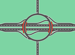
Roundabout and volleyball

Roundabout as a junction with four ramps, located on the A5 as AS Offenburg 48 ° 28 ′ 20 ″ N , 7 ° 54 ′ 14 ″ E
Roundabout, a six-ramp interchange, is on Interstate 95 near Waltham, Massachusetts . 42 ° 22 ′ 17 ″ N , 71 ° 16 ′ 9 ″ W.

Volleyball
design of AS Düsseldorf-Stockum (A 44) 51 ° 16 ′ 17 ″ N , 6 ° 45 ′ 2 ″ O
Throughabout as a junction, used several times in Guadalajara , on Avenue México. 20 ° 40 ′ 46 ″ N , 103 ° 23 ′ 3 ″ W 20 ° 39 ′ 59 ″ N , 103 ° 23 ′ 34 ″ W.


.svg)


.svg)
Half-leaf clover with ending feeder
A type of junction common in Baden-Württemberg is a mixture of partial clover and trumpet, which means that the traffic junction is not completely free of height with the same bridge area and leads to increased wear on asphalt and vehicles. According to the guidelines for the construction of motorways (RAA), it is only to be used as a makeshift. In terms of planning, it can be assumed that a continuation of the feeder was planned, which in many cases never took place, has meanwhile been built and made the traffic junction a permanent and avoidable environmental burden. In Switzerland, for reasons of space, this form is used in narrow valleys due to the differences in altitude and in industrial areas whose expansion is foreseeable. The junction Leonberg -Ost at 48 ° 46 '35 " N , 9 ° 1' 31" E of the A 8 shows how the capacity of the feeder is considerably restricted with two branches, while with the same bridge and asphalt surface a connection via two Trumpeting would have been possible. Historically, the Mühlhausen im Täle junction at 48 ° 35 '2 " N , 9 ° 39' 46" E , which also enables the turning possibility of the split A 8, was retained. A non foreseeable continuation of the feeder B 32 is the junction Horb Neckar A 81 at 48 ° 25 '51 " N , 8 ° 44' 43" O . This type of node is used more often on federal highways in Baden-Württemberg:
- 48 ° 52 '58 " N , 9 ° 3' 30" E B 10 nearHemmingen
- 48 ° 49 ′ 44 ″ N , 9 ° 19 ′ 55 ″ O B 14Waiblingen, an der Talaue (K1895)
- 48 ° 55 ′ 24 ″ N , 9 ° 9 ′ 9 ″ E B 27 nearTamm
- 48 ° 12 ′ 48 ″ N , 9 ° 52 ′ 43 ″ E B 30 nearLaupheim
- 48 ° 32 ′ 55 ″ N , 9 ° 15 ′ 54 ″ E B 312 North TangentMetzingen
- 48 ° 14 ′ 40 ″ N , 8 ° 51 ′ 17 ″ O B 463 nearWeilstetten
The junction of the B 464 built in 2012 on the K 1004 in the Sindelfingen urban area at 48 ° 42 ′ 38 ″ N , 8 ° 57 ′ 6 ″ E shifts the costs from construction to road users . The half diagonal clover is free of height in any direction. Destinations with need lead there via left-turn lanes and are therefore of secondary importance. The junction-free ramps lead to turning or driving a detour.
In the case of acute-angled streets that are connected with a diagonal clover, the loop ramps are better placed in the obtuse angles, as they cover the directions at no height if required by the road users. For example junction 16 of the French A 35 to the D 1422 near Schlettstadt at 48 ° 17 ′ 11 ″ N , 7 ° 27 ′ 27 ″ E or the last junction of the A 215 to the B 76 in the city of Kiel at 54 ° 18 ′ 55 " N , 10 ° 6 '11" O or the connection point Engen A 81 at 47 ° 51' 16 " N , 8 ° 47 '56" O .
Coupling of interchanges and service areas
Occasionally the area between the exits is used for a motorway service station. Such a location has the advantage that it is easily accessible even for road users who are not allowed to use the motorway. An example of such a rest stop is the Bruchsal motorway rest stop. However, the motorway exit is not signposted here, although it is open to public traffic.
Height-free connection points
These are high-performance junction points in the form of a motorway junction or motorway triangle , some of which have motorway-like feeder roads.
Junction points on motorways
Junction points of motorways with two directional lanes separated by a median do not differ in their design from those of motorways. However, there is not a numbering of the junctions on all four-lane motorways.
Junction points of motorways without a median, which have only one lane with at least two lanes , are often provided with only one entrance. At such junctions, you have to turn left on the motor road, which increases the risk of accidents in heavy traffic.

Frontage Road
A Frontage Road (literally Fassadenstraße ), also English access road , English service road , English parallel road , in eastern Texas English feeder (= feeder) or "Außengasse" is used in Germany only rudimentarily in this functionality, is imprecisely referred to as a parallel lane and is most common in Texas. It gives the motorway in densely built-up areas the functionality of connection and properties for city traffic. This parallel lane is a one-way street that does not run on either side of the motorway and is not free of height. Vehicles that are not approved for the motorway may drive on it. Another lane changes at regular intervals between the motorway and this one-way street and exchanges vehicles like a clover leaf . Since this lane does not end, it is not the cause of traffic jams. You can find it on the Katy Freeway in Houston , Texas , part of Interstate 10 and the US-90. In Germany, the maximum connection point density of two kilometers does not apply without exception. Otherwise, double junctions or - as with the Schönefeld junction on the A 113 - unbundling as with a Frontage Road are used. In Utah, the first Frontage Roads were built on the Mountain View Corridor (SR-85).
City highways and overturned ramps
If a parallel lane has multiple lanes and is part of the motorway, American traffic engineers refer to it as an English local express lane (= city motorway). In this case, only vehicles approved for motorways are permitted. For the connection of the two highways with one another either changing tracks, or be intertwined ramps ( English Braided Ramps ) used. In the Netherlands, these flyover structures are at the neighboring motorway intersections Knooppunt Ypenburg and Knooppunt Prins Clausplein ( 52 ° 3 ′ 15 ″ N , 4 ° 21 ′ 54 ″ E , 52 ° 3 ′ 15 ″ N , 4 ° 22 ′ 3 ″ E ) as well at Knooppunt Ridderkerk ( 51 ° 52 ′ 17 ″ N , 4 ° 33 ′ 42 ″ E , 51 ° 52 ′ 12 ″ N , 4 ° 33 ′ 43 ″ E ). The separation of the respective motorway routes should not transfer a traffic jam from one motorway to the other.
Commuter Road
A commuter road is a single-lane, elevation-free road with partial junctions that runs parallel to the route. This is only partially a one-way street. An example is the Timpanogos Highway Commuter Lane , a part of the UT-SR-92 in Lehi in the State of Utah at 40 ° 25 '58 " N , 111 ° 51' 54" W . Except for the shape and density of the junctions and the number of building contractors , it is roughly comparable to the federal highway 312 between Filderstadt-Bonlanden and Aichtal . These streets achieve their high capacity thanks to their height-free course. They are very economical for the vehicles as they do not have to stop and accelerate again.

The ramp at the Umeda exit leads through the Gate Tower Building

Hakozaki Interchange - junction with Japanese highways

Nachshonim interchange in 2012 (one ¾ in Israel)


Special forms
In addition to junction points that are continuously released for public transport, motorways or expressways can also have junction points that are used for operational or temporary purposes.
Partial connection / half connection
Under half connection is meant interchanges, tie not all possible directions of highway and feeder. Sometimes they are supplemented close with a connection for the missing directions. The partial connections include irregular connections with no entry or exit and all connections with only a single entry and / or entry.
Company connection point
A service connection point (also service ramp or service entrance or exit ) enables vehicles from the motorway and road maintenance departments as well as the fire , police and rescue services to enter and exit . It often does not have a deceleration or acceleration lane , is usually not signposted separately and is often additionally secured against unauthorized use with a locking device (for example a barrier or a gate). Service junctions are mainly located on route sections where the distances between the regular junctions are very large or where there are special facilities (such as ancillary facilities or road tunnels ) that may require a direct connection.
Makeshift connection point
A makeshift connection point (also a makeshift exit or entrance ) can be opened to traffic if necessary. This happens, for example, if the regular connection point cannot be used due to a construction site and the route to the next regular connection point is not reasonable or sensible. Behelfsanschlussstellen can also be opened after an accident to pent-up vehicles derive . There are also makeshift connection points that are regularly opened for major events (for example in stadiums or exhibition centers), such as the Borussiapark auxiliary connection point on the A 61 . There are also temporary junction points that are permanently open, for example on the A 5 . At the Bruchsal motorway service station, there are entry and exit options in both directions that can be used permanently by all vehicles, but are not signposted from the motorway. On the A 8 between Stuttgart and Ulm near Hohenstadt there is a makeshift junction, also signposted as such, at which you can drive up and down from both directions.
Makeshift connection points are usually similar to regular connection points and can be announced with appropriate signs (use of variable message signs is possible). In rare cases, makeshift junctions were either closed or upgraded to regular junctions in the course of expansion work, as these were often illegally used as regular junctions (such as the Neusäß junction on the A 8 near Augsburg ). This also applies to the makeshift junction of the Göttingen motorway service station on the A 7 , which is to be expanded into a regular junction in the future.
See also
- Departure block - temporary measure of traffic control planning
Web links
- Ágnes Lindenbach: Plan-free nodes. (PDF; 410 kB) Lecture 2, Roads and Railways II. BMEEOUV-N40. Budapest University of Technology and Economics, p. 9 ff. , Archived from the original on July 5, 2015 ; accessed on March 15, 2017 .
- Directory of German motorways with junctions
- DDI guideline. A UDOT guideline for Diverging Diamond Interchanges, Utah Department of Transportation, June 2014.
Individual evidence
- ^ Term connection point. PIARC Dictionary.
- ↑ a b c d e f g Institute for Roads and Railways at KIT: Design and Construction of Roads - Part: Road Design. (PDF; 8.44 MB). Retrieved September 7, 2013.
- ^ Indrajit Chatterjee, Siddharth Sharma: Comparative Analysis of Conventional Diamond Interchange and Contra Flow Left Turn (CFL) Interchange. ( Memento from July 18, 2010 in the Internet Archive ) (PDF; 540 kB) Center for Transportation Research and Education at Iowa State University, 2007.
- ↑ Unconventional Arterial Intersection Design. Contraflow Left Interchange. University of Maryland, ATTAP, accessed December 11, 2013.
- ^ Indrajit Chatterjee, Siddharth Sharma: Comparative Analysis of Conventional Diamond Interchange and Contra Flow Left Turn (CFL) Interchange. (PDF) Department of Civil and Environmental Engineering University of Missouri, Columbia, accessed July 20, 2015.
- ↑ a b Alternative Intersections / Interchanges: Informational Report (AIIR). FHWA Publication 2010.
- ↑ MiamiValleyRPC: Proposed Single Point Urban Interchange, Dayton, OH - a simulation of the SPUI , published on August 31, 2009.
- ↑ lauraKCICON: SPUI 3D ANIMATION FOR INTERSTATE 29/35 AND FRONT STREET. Published on August 24, 2009.
- ↑ Interchanges: SPUI . kurumi.com. Retrieved May 16, 2012.
- ↑ Jonathan Reid, PE : Unconventional arterial intersection design, management and operations strategies (PDF; 16.1 MB) Parsons Brinckerhoff . July 2004. Archived from the original on November 15, 2015. Retrieved on September 9, 2012.
- ↑ Single-point Urban Interchange (SPUI), aka Single-Point Diamond. Retrieved November 30, 2013.
- ^ South Dakota Decennial Interstate Corridor Study. (PDF), South Dakota Department of Transportation, March 2010, p. 273.
- ↑ Interstate 64 / US Route 40 Corridor. City of St. Louis and St. Louis County, Missouri. Environmental Impact Statement ( en ) 2005.
- ↑ Page no longer available , search in web archives: PDF.
- ↑ NCDOTcommunications: Diverging Diamond Interchange Visualization. Published as of March 10, 2011.
- ↑ Simulation of the DDI from MoDOT.
- ↑ Introduction from UDOT.
- ^ Harrodsburg Road Double Crossover Diamond (DCD) Interchange.
- ↑ Looking Back at the 100 Best Innovations of 2009.
- ^ I-64 Interchange at Route 15, Zion Crossroads. ( Memento of November 27, 2013 in the Internet Archive ) VDOT, accessed on March 12, 2013.
- ^ A Diamond Interchange With a Twist. ( Memento of July 1, 2012 in the Internet Archive ) Official website of the DDI.
- ^ Utah Department of Transportation. ( Memento from June 9, 2012 in the Internet Archive ) Page of the SR-92 at UDOT.
- ↑ https://www.google.com/maps/d/viewer?mid=1MMZKi0RdQqjZjtBxmSTznUVnurY
- ^ Diverging Diamond Interchange Locations. At: divergingdiamond.com. Retrieved August 19, 2017, verified with Google Maps .
- ^ Unique interchange, first of its kind in Canada, opens in south Calgary . In: CBC News . 13th August 2017.
- ↑ Bilister should be on the opposite side of the engine . January 5, 2017 ( fyens.dk [accessed February 5, 2017]).
- ↑ Ministeren markerede ibrugtagning af det dynamiske ruderanlæg - Nyheder - Vejdirektoratet.dk. Retrieved October 19, 2017 (da-dk).
- ↑ Dynamisk Ruderanlæg - Odense SV. Published on July 23, 2014, update from June 1, 2015.
- ↑ publisher.qbrick.com.
- ↑ Casper Gravlev Christensen, Torben Friis Nielsen: Dynamisk Ruderanlæg (DR) - Diverging Diamond Interchange (DDI). Vejdirektoratet, Skanderborg, accessed on February 5, 2017.
- ↑ Dynamiske Ruderanlæg - Det Digitale Projektbibliotek, Aalborg Universitet. Retrieved February 5, 2017 (Danish).
- ↑ Alternative Intersections and Interchanges .
- ↑ Australia gets first diverging diamond interchange . In: New Civil Engineer . ( newcivilengineer.com [accessed October 19, 2017]).
- ↑ 2014-03-21 TPDR REG. KODAS T00070644 , Lithuanian Road Administration under the Ministry of Transport and Communications (LAKD)
- ↑ https://www.rtbf.be/info/regions/brabant-wallon/detail_un-nouvel-echangeur-pour-supprimer-les-bouchons-au-carrefour-de-la-n4-et-de-la-n25 ? id = 9937634
- ↑ Alternative Intersection Control. At: dcmiinterchange.com. (Engl.)
- ^ Alternative Intersection Control, Sycamore (Illinois) .
- ↑ Patent US 20130011190 A1 ( WO 2013009704 A1 ): Double crossover merging interchange. Published on January 10, 2013.
- ↑ DCMI (Double Crossover Merging Interchange). Design, Operations, and Application. ( Memento of December 3, 2013 in the Internet Archive ) (PDF; 1.3 MB). At: ite.org. (English).
- ^ Diamonds and other 4-ramp interchanges. On: kurumi.com. ("Folded diamond").
- ↑ 49 ° 48 '24 " N , 6 ° 43' 27" E
- ↑ 48 ° 49 ′ 21 ″ N , 9 ° 53 ′ 28 ″ E
- ↑ 48 ° 3 '49 " N , 11 ° 42' 38" E
- ↑ Interchanges: Six-ramp . kurumi.com. Retrieved April 29, 2012.
- ↑ Ronald Reagan Freeway (CA-SR-118) 34 ° 16 ′ 56 ″ N , 118 ° 44 ′ 40 ″ W.
- ↑ a b Fictional Interchanges - SPUPCLO (Single-Point Urban Partial Cloverleaf). At: Kurumi.com. Retrieved February 23, 2013.
- ^ Joseph E. Hummer: Introduction to and Update on Unconventional Interchanges. ( Memento of December 16, 2014 in the Internet Archive ) (PDF). Regional Transportation Alliance, Raleigh NC, accessed June 27, 2014, p. 42.
- ↑ Field Guide to Interchanges. On: kurumi.com. Retrieved November 30, 2013.
- ^ Knooppunt Ypenburg in the Dutch language Wikipedia.
- ^ Knooppunt Ridderkerk in the Dutch language Wikipedia.
- ↑ Autobahn 7: The new exit should be called "Rosdorf". Göttinger Tageblatt, May 13, 2011, accessed on July 4, 2011.
Remarks
- Google Earth has aerial imagery on the subject. Historical aerial photographs are not available in the mobile version and the Earth plug-in of Google Maps .

DDI / DCD | Dumbbell | Dog bones | Contra Flow Left (CFL) | Florida T | Hamburger | Jughandle | Roundabout | Intersection with continuous traffic flow | Michigan Left | RCUT | Offset T | Diamond with an intersection | Seagull Intersection | SPUI | Superstreet | Split Intersection | Throughabout | Turbo-T