
Mühlhausen in the valley
| coat of arms | Germany map | |
|---|---|---|

|
Coordinates: 48 ° 35 ' N , 9 ° 39' E |
|
| Basic data | ||
| State : | Baden-Württemberg | |
| Administrative region : | Stuttgart | |
| County : | Goeppingen | |
| Height : | 544 m above sea level NHN | |
| Area : | 6.33 km 2 | |
| Residents: | 1057 (December 31, 2018) | |
| Population density : | 167 inhabitants per km 2 | |
| Postcodes : | 73347, 73349 | |
| Area code : | 07335 | |
| License plate : | GP | |
| Community key : | 08 1 17 035 | |
| LOCODE : | DE MYH | |
| Address of the municipal administration: |
Gosbacher Strasse 16 73347 Mühlhausen im Täle |
|
| Website : | ||
| Mayor : | Bernd Schaefer | |
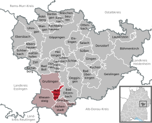
| Location of the community of Mühlhausen im Täle in the district of Göppingen | ||
  |
||


Mühlhausen im Täle is a municipality in Baden-Württemberg on the upper reaches of the Fils in the district of Göppingen .
geography
Geographical location
The main town of Mulhouse the community is on the top, still on the Swabian Alb running Fils valley just before the left tributary of the Hollbachs or hollow Bach , the county seat km as the crow flies about 14 south Göppingen , as far west-southwest of Geislingen , about 32 km northwest of the City of Ulm and about 42 km east-southeast of the state capital Stuttgart .
The municipal area includes the valley level with the settlement focus, but to a large extent the valley slopes and plateaus over the three valley axes. The lowest point at about 535 m above sea level. NN is at the outflow of the Fils from the municipality, the highest on a knoll of the Alb plateau on the western edge of the municipality reaches 820.6 m above sea level. NN , while the eponymous village with the largest proportion of the population in the valley heights of 544 m above sea level. NN occupies.
Neighboring communities
The municipal area of Mühlhausen im Täle is bordered in turn by the municipalities of Gruibingen in the north-northwest, Bad Ditzenbach in the southeast, in the very south just briefly Drackenstein and in the west-southwest the town of Wiesensteig , all four of which also belong to the Göppingen district .
Community structure
Mühlhausen im Täle includes the village of Mühlhausen im Täle, the Eselhöfe district and the Todtsburg house, as well as the abandoned village of Tiufental.
Division of space

According to data from the State Statistical Office , as of 2014.
history
Until the 19th century
Row graves from Merovingian times have been found in the municipality. Mühlhausen was mentioned for the first time in the Lorsch Codex as early as 812 , earlier than any other place in today's district of Göppingen. In 861 the place was mentioned as part of the founding equipment of the Wiesensteig monastery . Mühlhausen has belonged to the Counts of Helfenstein since the 12th century . In 1806 it came - like the entire upper Filstal - as part of mediatization to the Kingdom of Württemberg . This initially assigned it to the Oberamt Wiesensteig , which was added to the Oberamt Geislingen after just three years .
20th century
In the course of the district reform in 1938, Mühlhausen became part of the Göppingen district.
In 1957, the Alb ascent of the federal highway 8 was completed at Mühlhausen and Wiesensteig .
With the approval of the state government on November 24, 1959, the municipality name was changed from Mühlhausen to Mühlhausen im Täle .
Population development
Source: Baden-Württemberg State Statistical Office for data from 1970
| date | Residents |
|---|---|
| 1837 | 474 |
| 1907 | 365 |
| May 17, 1939 | 562 |
| September 13, 1950 | 682 |
| May 27, 1970 | 849 |
| December 31, 1983 | 937 |
| May 25, 1987 | 936 |
| December 31, 1991 | 1048 |
| December 31, 1995 | 1073 |
| December 31, 2005 | 1022 |
| December 31, 2010 | 978 |
| December 31, 2015 | 1019 |
politics
Associations
Together with Wiesensteig, Drackenstein , Gruibingen and Hohenstadt , Mühlhausen im Täle has formed the Upper Filstal Municipal Administration Association since 1972 .
The community of Mühlhausen im Täle is also a member of
- Schulverband Upper Fils Valley
- Abwasserverband Oberes Filstal
- Special purpose association for inter-municipal cooperation (Mühlhausen and Gruibingen )
Municipal council
The municipal council in Mühlhausen im Täle has eight members. In the local elections on May 26, 2019 , the local council was elected by majority vote. Majority voting takes place if no or only one nomination has been submitted. The applicants with the highest number of votes are then elected. The municipal council consists of the voluntary councilors and the mayor as chairman. The mayor is entitled to vote in the municipal council.
mayor
The former mayor Gebhard Tritschler moved in mid-May 2010 as the new mayor of the neighboring town of Wiesensteig. His successor was Bernd Schaefer, who took office in June 2010.
coat of arms
The blazon of the municipal coat of arms of Mühlhausen im Täle reads: A silver cuckoo in red on a silver branch .
The local colors are white and red. The earlier community seal showed a clasp, probably a stain mark . In 1930 the municipality adopted the coat of arms in its current form: red and white are the colors of the Rechberg house , the cuckoo is the nickname of the surrounding villages for the residents of Mühlhausen. Since the cuckoo is a "beautiful and clever bird", it finds its place in the municipal coat of arms. Both the coat of arms and the flag were officially awarded by the Ministry of the Interior on February 19, 1959.
Economy and Infrastructure
traffic
Mühlhausen is connected to the national road network by the federal motorway 8 . Other roads that connect Mühlhausen are the federal road 466 and the state roads 1200 and L 1217.
The Geislingen an der Steige – Wiesensteig railway line , popularly known as the valley railway, and the Mühlhausen-Gruibingen railway station located at it, was in operation from 1903 to 1968 as far as Mühlhausen. The Royal Württemberg State Railways built the station building as a standard type IIa station. Today bus routes connect Mühlhausen u. a. with the cities of Göppingen, Geislingen and Wiesensteig.
Companies
In Mühlhausen there are mainly small and medium-sized businesses, many of them artisanal. On the outskirts of Mühlhausen there was a Kodak plant with up to 900 employees from 1970 to 2003 . In the end, this was owned by Heidelberger Druckmaschinen AG . The plant on the outskirts of Mühlhausen was mostly on the Gruibingen district, and the much smaller one on Mühlhausen. Today, several companies from the automotive sector have settled in the buildings . Thanks to its convenient location on the motorway, there are several restaurants in Mühlhausen.
Culture and sights
The Swabian Albstraße runs through Mühlhausen and leads past many sights.
caves
There are three geologically significant caves within the municipality. The Todtsburger Höhle and Todtsburger Schacht have been developed . While the Todtsburger Höhle is freely accessible, you need sufficient mountaineering and climbing knowledge and the appropriate material for the shaft. The tuff stone cave next to the hamlet of Todtsburg is no longer accessible.
Buildings
- Medieval stables of Mühlhausen Castle next to the church (half destroyed by modern development)
Sports
The TSV Obere Fils e. V. was founded on June 24, 1972 through the merger of the two clubs TSV Wiesensteig and TSV Mühlhausen and offers the residents of the community of Mühlhausen and the city of Wiesensteig a variety of sports-related activities. In addition, there is also an amateur play group which, with their performances in Mühlhausen and in the castle in Wiesensteig, ensures a lively rush of visitors once a year. Sports fields are located in both Mühlhausen and Wiesensteig. Both sports fields have a clubhouse. However, the sports field in Mühlhausen is only used for training purposes and events. The new club house and the modern sports field for games are located in Wiesensteig.
Personalities
- Felix Nabor (1863–1946), folk writer
literature
- Werner Mutschler: Mühlhausen im Täle - in old and new pictures. [Mayor's Office]; Mühlhausen im Täle: Self-published by W. Mutschler, 2012. (without ISBN, in the holdings of the Württemberg State Library in Stuttgart)
Web links
Individual evidence
- ↑ State Statistical Office Baden-Württemberg - Population by nationality and gender on December 31, 2018 (CSV file) ( help on this ).
- ^ The state of Baden-Württemberg. Official description by district and municipality. Volume III: Stuttgart District, Middle Neckar Regional Association. Kohlhammer, Stuttgart 1978, ISBN 3-17-004758-2 , pp. 351-352.
- ↑ State Statistical Office, area since 1988 according to actual use for Mühlhausen im Täle.
- ^ Rainer Stein: The Württemberg standard station on branch lines . In: Eisenbahn-Journal Württemberg-Report . tape 1 , no. V / 96 . Merker, Fürstenfeldbruck 1996, ISBN 3-922404-96-0 , p. 80-83 .
- ↑ ANETTE KÖLLE: Kodak in Mühlhausen lives on in the master's regulars ' table. Retrieved September 1, 2016 .
- ↑ Economy / Transport. In: www.muehlhausen-taele.de. Retrieved September 1, 2016 .

Adelberg | Aichelberg | Albershausen | Bad Boll | Bad Ditzenbach | Bad Ueberkingen | Birenbach | Böhmenkirch | Börtlingen | Deggingen | Donzdorf | Drackenstein | Dürnau | Ebersbach an der Fils | Eislingen / Fils | Eschenbach | Gammelshausen | Geislingen an der Steige | Went to the Fils | Göppingen | Gruibingen | Hattenhofen | Heiningen | Hohenstadt | Cake | Lauterstein | Mühlhausen im Täle | Ottenbach | Rechberghausen | Salach | Schlat | Schlierbach | Cuties | Uhingen | Cheeks | Waschenbeuren | Wiesensteig | Zell under Aichelberg