
Böhmenkirch
| coat of arms | Germany map | |
|---|---|---|

|
Coordinates: 48 ° 41 ′ N , 9 ° 56 ′ E |
|
| Basic data | ||
| State : | Baden-Württemberg | |
| Administrative region : | Stuttgart | |
| County : | Goeppingen | |
| Height : | 696 m above sea level NHN | |
| Area : | 51.09 km 2 | |
| Residents: | 5527 (December 31, 2018) | |
| Population density : | 108 inhabitants per km 2 | |
| Postcodes : | 89558, 73312 | |
| Area code : | 07332 | |
| License plate : | GP | |
| Community key : | 08 1 17 010 | |
| LOCODE : | DE BMC | |
| Address of the municipal administration: |
Hauptstrasse 100 89558 Böhmenkirch |
|
| Website : | ||
| Mayor : | Matthias Nägele | |
| Location of the municipality of Böhmenkirch in the district of Göppingen | ||
  |
||


Böhmenkirch is a municipality in the district of Göppingen in Baden-Württemberg .
geography
Geographical location
Böhmenkirch lies at an altitude of 495 to 746 m above sea level. NN height on the Albuch called part of the plateau of the Swabian Alb between Upper Brenz - and Kochertal in the east-northeast and the great arch of the Fils in the west-southwest. The eponymous village of the municipality is about 21 km as the crow flies from the district town of Göppingen in the west and about 32 km from the city of Ulm in the south.
Community structure
The formerly independent communities of Schnittlingen, Steinenkirch and Treffelhausen belong to Böhmenkirch. The village of Böhmenkirch and the hamlet of Heidhöfe as well as the abandoned villages of Schönenberg, Neuhausen, Boxweiler, Hoebert and Siggenweiler belong to the municipality of Böhmenkirch within the limits of December 31, 1972 . The village of Schnittlingen and the houses Berg ( radio station ) and Ziegelhütte as well as the abandoned villages Wintereswanc and Winterreute belong to the former municipality of Schnittlingen . The village of Steinenkirch, the hamlet of Trasenberg, the Lindenhof farmstead and the houses Obere Roggenmühle and Ravenstein belong to the former municipality of Steinenkirch . The village of Treffelhausen belongs to the former municipality of Treffelhausen.
Neighboring communities
The communities of Bartholomä in the north in the Ostalb district border in turn on the municipality of Böhmenkirch ; Steinheim am Albuch in the east and Gerstetten in the southeast, both in the district of Heidenheim ; and the cities of Geislingen an der Steige in the southwest, Donzdorf in the west and Lauterstein in the northwest, all three in their own district of Göppingen .
Division of space
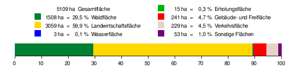
According to data from the State Statistical Office , as of 2014.
history
middle Ages
Böhmenkirch was first mentioned in a Vatican register in 1225 as Bominwirche . In 1302, Böhmenkirch is in the possession of the Counts of Helfenstein as pledge of the empire . Count Ulrich III. In 1307 von Helfenstein was forced to pledge territories, including Böhmenkirch, to Albert I. von Rechberg due to his indebtedness . Böhmenkirch was an imperial estate and enjoyed special rights that played a role in the Böhmenkirch peasant uprising from 1580 to 1582 against Haug (Hugo) von Rechberg.
Modern times
The knighthood of Rechberg lost its imperial immediacy during the Napoleonic period . In 1806 Böhmenkirch fell to the Kingdom of Württemberg .
Fire disaster in 1910
On April 14, 1910, aggravated by lack of water and thatched roofs, a fire disaster occurred in which 74 houses were destroyed and 372 people were left homeless.
Incorporations
In the course of the community reform in Baden-Württemberg, on January 1, 1973, Treffelhausen and Schnittlingen and on January 1, 1974 Steinenkirch were incorporated.
Coats of arms of the incorporated places
 Treffelhausen |
 Cut pieces |
 Steinenkirch |
|---|
Population development
Source: Baden-Württemberg State Statistical Office for data from 1961
| date | Residents |
|---|---|
| 1837 | 2565 |
| 1907 | 2671 |
| May 17, 1939 | 2683 |
| September 13, 1950 | 3906 |
| June 6, 1961 | 4018 |
| May 27, 1970 | 4510 |
| December 31, 1983 | 4576 |
| May 25, 1987 | 4633 |
| December 31, 1990 | 4902 |
| December 31, 1995 | 5427 |
| December 31, 2000 | 5620 |
| December 31, 2005 | 5601 |
| December 31, 2010 | 5515 |
| December 31, 2015 | 5512 |
politics
Municipal council
In Böhmenkirch, the municipal council is elected according to the procedure of the spurious partial location selection . The number of local councils can change due to overhang mandates . The municipal council in Böhmenkirch has 20 members after the last election (unchanged). The local election on May 26, 2019 led to the following official final result. The municipal council consists of the elected voluntary councilors and the mayor as chairman. The mayor is entitled to vote in the municipal council.
| Parties and constituencies |
% 2019 |
Seats 2019 |
% 2014 |
Seats 2014 |
||
| FWG | Free voter community Böhmenkirch | 55.98 | 11 | 61.36 | 12 | |
| CDU | Free Citizens' Association / Christian Democratic Union of Germany | 44.02 | 9 | 38.64 | 8th | |
| total | 100.0 | 20th | 100.0 | 20th | ||
| voter turnout | 54.17% | 56.93% | ||||
coat of arms
The blazon of the municipal coat of arms of Böhmenkirch reads: In red a golden wooden church .
For the year 1924 a tree is documented as a seal image for Böhmenkirch. Later it changed into a church. Following a proposal from the archive management in Stuttgart, the community adopted today's “ talking coat of arms ” in 1957 : The place name Böhmenkirch is derived from Baumenkirche , which is symbolized by a church made of tree wood. The colors yellow and red indicate the Rechberg rule. The coat of arms and the yellow-red flag were awarded on September 4, 1958 by the Ministry of the Interior.
Community partnerships
Böhmenkirch maintains partnership relationships with the market town of Böheimkirchen in the Mostviertel in Lower Austria .
Economy and Infrastructure
traffic
Böhmenkirch is connected to the national road network by the federal highway 466 ( Süßen - Heidenheim ). In public transport , the community is a crossing point for bus connections between Göppingen , Geislingen an der Steige and Heidenheim an der Brenz .
education
There is a primary and secondary school in Böhmenkirch and a pure primary school in the district of Treffelhausen.
Culture and sights
Tourist routes
Böhmenkirch is located on the Swabian Albstraße , which leads past many sights. Böhmenkirch is also located on the Franconian-Swabian Way of St. James , a pilgrimage route that leads to Ulm and on to Spain.
Buildings

- Telecommunication tower Schnittlingen
- Wind farm at the telecommunications tower
- Upper rye mill
- St. Patrick's Chapel
- St. Vitus Church in Treffelhausen
- Lourdes grotto in Treffelhausen
- Burgrest Ravenstein in Steinenkirch
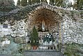
Lourdes grotto in Treffelhausen

Center of Böhmenkirch, drawing by Margret Hofheinz-Döring , 1977

Schnittlingen, drawing by M. Hofheinz-Döring, 1982

Treffelhausen, drawing by M. Hofheinz-Döring, 1981


Natural monuments
- Mordloch in Roggental, at 4.3 km the third longest cave in the Swabian Alb
- Magenta with the rocks of rye stone and rye needle
- Eybquelle below Treffelhausen
energy

To the northeast of Böhmenkirch there is a wind farm in which 4 wind turbines of the 1.5 MW class are installed.
Sons and daughters of the church
- Anna Meder (1606–1649), printer
- Georg Grupp (1861–1922), theologian, historian and librarian
- Bernhard Heinzmann (1903–1942), Catholic priest and opponent of the Nazi regime
- Nikolas Knoblauch (* 1995), football player
- Lena Urbaniak (* 1992), track and field athlete
Web links
Individual evidence
- ↑ State Statistical Office Baden-Württemberg - Population by nationality and gender on December 31, 2018 (CSV file) ( help on this ).
- ^ The state of Baden-Württemberg. Official description by district and municipality. Volume III: Stuttgart District, Middle Neckar Regional Association. Kohlhammer, Stuttgart 1978, ISBN 3-17-004758-2 . Pp. 279-282.
- ↑ State Statistical Office, area since 1988 according to actual use for Böhmenkirch.
- ^ Federal Statistical Office (ed.): Historical municipality directory for the Federal Republic of Germany. Name, border and key number changes in municipalities, counties and administrative districts from May 27, 1970 to December 31, 1982 . W. Kohlhammer, Stuttgart / Mainz 1983, ISBN 3-17-003263-1 , p. 449 and 461 .
- ↑ Election information for the municipal data center

Adelberg | Aichelberg | Albershausen | Bad Boll | Bad Ditzenbach | Bad Ueberkingen | Birenbach | Böhmenkirch | Börtlingen | Deggingen | Donzdorf | Drackenstein | Dürnau | Ebersbach an der Fils | Eislingen / Fils | Eschenbach | Gammelshausen | Geislingen an der Steige | Went to the Fils | Göppingen | Gruibingen | Hattenhofen | Heiningen | Hohenstadt | Cake | Lauterstein | Mühlhausen im Täle | Ottenbach | Rechberghausen | Salach | Schlat | Schlierbach | Cuties | Uhingen | Cheeks | Waschenbeuren | Wiesensteig | Zell under Aichelberg