
Schlat
| coat of arms | Germany map | |
|---|---|---|

|
Coordinates: 48 ° 39 ' N , 9 ° 42' E |
|
| Basic data | ||
| State : | Baden-Württemberg | |
| Administrative region : | Stuttgart | |
| County : | Goeppingen | |
| Height : | 412 m above sea level NHN | |
| Area : | 9.68 km 2 | |
| Residents: | 1697 (December 31, 2018) | |
| Population density : | 175 inhabitants per km 2 | |
| Postal code : | 73114 | |
| Area code : | 07161 | |
| License plate : | GP | |
| Community key : | 08 1 17 043 | |
| LOCODE : | DE SHC | |
| Address of the municipal administration: |
Hauptstrasse 2 73114 Schlat |
|
| Website : | ||
| Mayoress : | Gudrun Flogaus | |
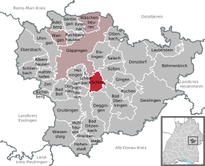
| Location of the municipality of Schlat in the district of Göppingen | ||
  |
||


Schlat is a municipality in the district of Göppingen in Baden-Württemberg . It belongs to the Stuttgart region (until 1992 the Middle Neckar region ) and the peripheral zone of the European metropolitan region of Stuttgart .
geography
Geographical location
Schlat is about seven kilometers south-east of Göppingen as the crow flies and belongs to the outskirts of the Stuttgart metropolitan region . The municipal area is located under the Albtrauf in the step edge bay of the Fils tributary, the Weilerbach, lined by Fränkel ( 680.6 m above sea level ) in the east, Wasserberg ( 751 m above sea level ) in the south and Fuchseck ( 761 m above sea level ) in the southwest , at about 372 m above sea level. NN leaves the community. The highest point of the community at the spur bend of the Fuchseck, a little below its summit, reaches about 761 m above sea level. NN , while the municipal boundary moves over the slightly lower summit of the water mountain.
Neighboring communities
The municipality of Schlat borders in turn with the city of Göppingen in the north-northwest and the city of Süßen in the northeast , further with the municipalities of Bad Überkingen in the southeast, Deggingen in the south, Bad Ditzenbach and Heiningen briefly in the southwest and in the rest of the west with the municipality Eschenbach . All neighboring municipalities are in their own district of Göppingen .
Community structure
The village of Schlat, the hamlet of Rommental and the farmstead Fuchseckhof as well as the abandoned villages of Zillenhart ( Zillenhart Castle ) and Dollenkirchle belong to Schlat.
Division of space

According to data from the State Statistical Office , as of 2014.
history


Early history
Several burial mounds in the area suggest that the first settlement was during the Iron Age . In the local area there is a burial ground from the Merovingian period , from which the fragment of a Hungarian stirrup is said to come from. Schlat was first mentioned in a document in 1139. At that time it was in the Duchy of Swabia .
Religions
Schlat has been evangelical since the Reformation , but the Roman Catholic believers who do not have their own community in the village have been allowed to use the St. Andrew's Church since the 1950s.
Population development
Source: Baden-Württemberg State Statistical Office for data from 1970
| date | Residents |
|---|---|
| 1837 | 761 |
| 1907 | 831 |
| May 17, 1939 | 809 |
| September 13, 1950 | 1133 |
| May 27, 1970 | 1465 |
| December 31, 1983 | 1589 |
| May 25, 1987 | 1634 |
| December 31, 1991 | 1723 |
| December 31, 1995 | 1699 |
| December 31, 2005 | 1775 |
| December 31, 2010 | 1727 |
| December 31, 2015 | 1682 |
politics
Municipal council
The local council in Schlat consists of ten members. In the local elections on May 26, 2019 , the local council was elected by majority vote. Majority voting takes place if no or only one nomination has been submitted. The applicants with the highest number of votes are then elected. The municipal council consists of the voluntary councilors and the mayor as chairwoman. The mayor is entitled to vote in the municipal council.
mayor
- 1868–1886: Johann Leonh. Whiting
- 1886–1901: Johannes Mayer
- 1901–1907: Friedrich Wilhelm Binder
- 1907–1919: Ernst Zänglein
- 1919–1939: Karl Sihler
- 1939–1944: While Mayor Sihler was absent, the second deputy Werner ran the mayor's affairs
- 1944–1956: Albert Mayer (acting mayor)
- 1945–1948: Otto Retter
- 1948–1982: Georg Mühlhäuser
- 1982–1998: Roland Schmid
- 1998–2010: Bernd Welser
- since 2010: Gudrun Flogaus. Ms. Flogaus was elected mayor on February 28, 2010 with 77.8% of the vote.

coat of arms
The blazon of the Schlat municipal coat of arms reads: In gold, under a green apple branch with a red apple lying on the right, a grazing red sheep .
The coat of arms reflects the traditional branches of business, fruit growing and cattle breeding. The coat of arms and the red and yellow municipal flag were awarded by the Interior Ministry on June 30, 1959.
Economy and Infrastructure
traffic
Schlat is connected to the Göppingen districts of Ursenwang , Holzheim and Manzen as well as Reichenbach iT by a state road . A district road leads to the neighboring Süßen . There is also a community road to Eschenbach . The district town of Göppingen can be reached by bus. On the line of the Voralbbahn there was a stop called Schlat. However, this was far away from the town in the district of Göppingen. The Ursenwang settlement was built near Schlater Bahnhof from 1962. The station kept the name Schlat until the closure of the Voralbbahn in 1989.
Companies
In Schlat there are mainly small to medium-sized companies, including a. various craft businesses. The community is also the location of several restaurants as well as pensions and hotels. Fruit growing is traditionally practiced in Schlat and fruit wine and fruit brandy are also produced. The use of the term "champagne" for a sparkling pear wine made from the champagne frying pear in Schlat concerned the Federal Court of Justice in 2005 .
Attractions

In 1472 the Protestant St. Andrew's Church was built at the highest point of the town center after the Reformation and is consecrated to the Apostle Andrew . In 1584 it was expanded to a transverse church with a south pulpit and three-sided gallery without a choir . In 1779 a tower was built again on an old tower basement. The last exterior and interior renovation was carried out in 2015. A special feature of the church is the shared use by the Catholic and Protestant congregations.
Sons and daughters of the church
- Johannes Mühlhäuser (1834–1914), viticulture specialist, member of the state parliament
literature
- Max Miller , Gerhard Taddey (ed.): Handbook of the historical sites of Germany . Volume 6: Baden-Württemberg (= Kröner's pocket edition . Volume 276). 2nd, improved and enlarged edition. Kröner, Stuttgart 1980, ISBN 3-520-27602-X , p. 704.
- Otto Schurr: History of Schlat , Schlat 1970
Web links
Individual evidence
- ↑ State Statistical Office Baden-Württemberg - Population by nationality and gender on December 31, 2018 (CSV file) ( help on this ).
- ^ The state of Baden-Württemberg. Official description by district and municipality. Volume III: Stuttgart District, Middle Neckar Regional Association. Kohlhammer, Stuttgart 1978, ISBN 3-17-004758-2 . Pp. 330-331
- ↑ State Statistical Office, area since 1988 according to actual use for Schlat.
- ↑ n-tv news television: Wherever there is a roasting pear ...: ... should be a roasting pear on it. Retrieved August 29, 2016 .

Adelberg | Aichelberg | Albershausen | Bad Boll | Bad Ditzenbach | Bad Ueberkingen | Birenbach | Böhmenkirch | Börtlingen | Deggingen | Donzdorf | Drackenstein | Dürnau | Ebersbach an der Fils | Eislingen / Fils | Eschenbach | Gammelshausen | Geislingen an der Steige | Went to the Fils | Göppingen | Gruibingen | Hattenhofen | Heiningen | Hohenstadt | Cake | Lauterstein | Mühlhausen im Täle | Ottenbach | Rechberghausen | Salach | Schlat | Schlierbach | Cuties | Uhingen | Cheeks | Waschenbeuren | Wiesensteig | Zell under Aichelberg