
Gruibingen
| coat of arms | Germany map | |
|---|---|---|

|
Coordinates: 48 ° 36 ' N , 9 ° 39' E |
|
| Basic data | ||
| State : | Baden-Württemberg | |
| Administrative region : | Stuttgart | |
| County : | Goeppingen | |
| Height : | 565 m above sea level NHN | |
| Area : | 23.05 km 2 | |
| Residents: | 2272 (December 31, 2018) | |
| Population density : | 99 inhabitants per km 2 | |
| Postcodes : | 73344, 73235 | |
| Area code : | 07335 | |
| License plate : | GP | |
| Community key : | 08 1 17 028 | |
| LOCODE : | DE GBE | |
| Address of the municipal administration: |
Hauptstrasse 18 73344 Gruibingen |
|
| Website : | ||
| Mayor : | Roland Schweikert | |
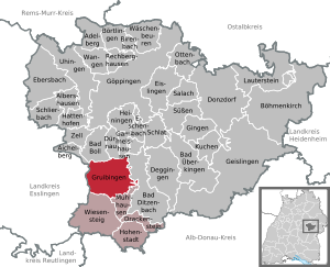
| Location of the community Gruibingen in the district of Göppingen | ||
  |
||


Gruibingen is a municipality in the district of Göppingen in Baden-Württemberg .
geography
Geographical location
Gruibingen is located between Stuttgart and Ulm in front of the Swabian Alb in a side valley of the Fils . The federal motorway 8 runs between Aichelberg and Mühlhausen im Täle east of the village.
Community structure
The village of Gruibingen, the homestead Kaltenwanghof and the house Exenmühle as well as the abandoned villages Chaldenwank and Ulrichstetten (?) Belong to Gruibingen.
Division of space

According to data from the State Statistical Office , as of 2014.
history
Until the 18th century
Archaeological excavations in St. Martin's Church show that the settlement of the Gruibinger Valley goes back to the early Middle Ages. Grave finds prove the presence of rich people on site: Among other things, a gold earring was found, which indicates a formerly very richly decorated noble grave. There are also references to the burial of a cleric whose grave furnishings reveal references to the Romanesque, perhaps Burgundian area. Traces of settlement from the Merovingian and Carolingian times can be found directly north of the Martinskirche and at the northern exit of the village, which indicates an originally polycentric settlement structure.
Gruibingen was first mentioned in a document in 861 in the foundation letter for the establishment of the Wiesensteig monastery . In it the monastery was described as lying in griubingaro marco . Various indications in connection with the monastery foundation indicate that Gruibingen was still an important point of rule at that time and the monastery foundation could possibly have originated from Gruibingen.
Nevertheless, none of these manors succeeded in establishing a local government. Gruibingen still had high jurisdiction , its own measure and an ancient market law . In the 15th century it was even referred to as a free village, which underlines its importance again.
Only between 1418 and 1533 was Gruibingen revoked the status of a free village by the rule of Württemberg and the old freedoms and rights were restricted. During the Reformation the place became Protestant as part of Württemberg . From now on Gruibingen was not only on the rulership border between the Duchy of Württemberg and the County of Helfenstein , but also on a religious border between the Protestant and the Catholic denominations, which was to influence further development.
During the Thirty Years War (1618-1648) there was hardship and misery; 131 men died from the effects of war, epidemics and disease. Towards the end of the war in 1647 the village was looted and set on fire. 130 houses and barns burned down. Already 21 years later there was another fire disaster, which was triggered by a village blacksmith and to which the whole place, with the exception of the church, rectory, fruit box, tithe barn and a single farmhouse fell victim. Seven people died in the flames.
The place could not grow back to its original size and in 1712 it is even said that “no rhinestones passed through the patch”. The economic conditions were largely limited to small-scale agriculture and a few craftsmen.
19th and 20th centuries
Gruibingen was largely cut off from industrialization in the 19th century, the residents continued to live from agriculture and small ancillary trades.
It was not until the 20th century that employment opportunities outside of agriculture became available. Since the Second World War , Gruibingen has developed into a stately village with a good infrastructure , several craft businesses and medium-sized companies.
Religions

Gruibingen has been evangelical since the Reformation . Today there is only one Protestant parish in town. Nevertheless, there is currently a balance between Protestants and Catholics in Gruibingen , the latter form a separate parish with the neighboring community of Mühlhausen im Täle , which in turn is a pastoral care unit together with the parishes of Hohenstadt and Wiesensteig . The priest , who lives in the main parish of Wiesensteig, takes care of all four parishes.
Population development
Source: Baden-Württemberg State Statistical Office for data from 1970
| date | Residents |
|---|---|
| 1837 | 933 |
| 1907 | 926 |
| May 17, 1939 | 945 |
| September 13, 1950 | 1248 |
| May 27, 1970 | 1467 |
| December 31, 1983 | 1709 |
| May 25, 1987 | 1836 |
| December 31, 1991 | 2317 |
| December 31, 1995 | 2351 |
| December 31, 2005 | 2204 |
| December 31, 2010 | 2067 |
| December 31, 2015 | 2200 |
politics
Administrative association
Gruibingen has merged with Drackenstein , Hohenstadt , Mühlhausen im Täle and Wiesensteig to form the Upper Filstal community administration association.
mayor
Roland Schweikert, a non-party member, was re-elected for the third term in May 2012.
Municipal council
The municipal council in Gruibingen has 10 members. The local elections on May 26, 2019 led to the following final result. The municipal council consists of the elected voluntary councilors and the mayor as chairman. The mayor is entitled to vote in the municipal council.
| Parties and constituencies |
% 2019 |
Seats 2019 |
% 2014 |
Seats 2014 |
% 2009 |
Seats 2009 |
% 2004 |
Seats 2004 |
| Free Community of Voters / Free Independent Voters | 42.33 | 4th | 69.6 | 6th | 77.2 | 8th | 80.6 | 8th |
| List of women | 27.75 | 3 | - | - | 22.8 | 2 | 19.4 | 2 |
| Alternative for Gruibingen | 29.92 | 3 | 30.4 | 4th | - | - | - | - |
| total | 100 | 10 | 100 | 10 | 100 | 10 | 100 | 10 |
| Voter turnout in% | 58.84 | 57.6 | 59.4 | 57.6 | ||||
coat of arms
The blazon of the municipal coat of arms of Gruibingen reads: In green a silver ram's horn in the form of a left sub-snail .
The ram's horn, a figure of the former local nobility, has been on the community's official seal since 1930. At the suggestion of the archives department in Stuttgart , the Widderhorn was created in 1958 based on the model of a seal used by Albrecht von Gruibingen. The town's flag is white and green. The coat of arms and flag were awarded by the Ministry of the Interior on February 18, 1959 .
Economy and Infrastructure

traffic
Gruibingen is connected to the national road network by the federal motorway 8 . A bus company based in Gruibingen connects the town with the district town of Göppingen .

Gruibingen-Nortel airfield
Even before the Second World War , the Gruibingen-Nortel glider airfield was located in the Gruibingen district , which is now home to the AeroClub Göppingen-Salach. In 2014 it was expanded to a special airfield and thus an upgrade, especially for motor-powered aircraft.
Companies
In Gruibingen there are mainly small and medium-sized companies, many of them from the craft sector. The largest companies include moll Funktionmöbel GmbH , a manufacturer of home office and children's furniture that grows with the child, which exports its products to over 50 countries, and Moll, Tief und Straßenbau GmbH & Co with over 100 employees. From 1970 to 2003 there was a Kodak plant on the border with Mühlhausen , in which up to 900 people worked. Although the plant was located on the outskirts of Mühlhausen, most of it was in the Gruibingen district, only a small part in Mühlhausen. Today, several companies from the automotive sector have settled in the buildings .
Educational institutions
There is only one elementary school in Gruibingen . Secondary schools must be attended in the neighboring towns. There is a community kindergarten for the little ones .
Culture and sights
Buildings

Ev. Martinskirche: The massive, square west tower was probably built mainly in the 12th century. The hall church contains important wall paintings from the time of the beginning of the 14th century to the 15th century.
Rasthaus Gruibingen: In 2003, the first motorway rest house in Europe built and equipped according to the principles of Feng Shui was opened on the A 8 .

The Franzosenschlucht viaduct is a bridge on the A 8 over the Franzosenschlucht.
Viewpoints
Rufstein: Viewpoint on the mountain Rufstein, coll too. Felsa (rock) called
Sons and daughters of the church
- Johann Christoph Albert Moll (1817–1895), doctor and medical historian
- Gustav Heinrich Lamparter (1826–1898), Oberamtmann, District President in Ulm
- Dorkas Reinacher-Härlin (1885–1968), ceramicist
- Jochen Stutzky (* 1980), football commentator and television presenter

Hilsenbeck Lamb Brewery
Gruibingen is known for its beer . The Hilsenbeck lamb brewery was first mentioned in 1728, but at that time it was still under the name Allmendinger. Hilsenbeck's well beer "naturally cloudy" was tapped for the first time in 1988 from the Gruibinger village well. The naturally cloudy beer has an original wort content of 12.5% and is bottled directly from the storage cellar and not filtered beforehand.
literature
- Werner Unseld, Walter Friess, J. Böhringer: Auf dr Gass ond behind the house - Gruibingen around 1935 in photographs by Walter Frieß . Illustrated book. Konrad, Weissenhorn 1994, ISBN 3-87437-364-9 .
Web links
Individual evidence
- ↑ State Statistical Office Baden-Württemberg - Population by nationality and gender on December 31, 2018 (CSV file) ( help on this ).
- ^ The state of Baden-Württemberg. Official description by district and municipality. Volume III: Stuttgart District, Middle Neckar Regional Association. Kohlhammer, Stuttgart 1978, ISBN 3-17-004758-2 . Pp. 348-350
- ↑ State Statistical Office, area since 1988 according to actual use for Gruibingen.
- ↑ https://www.staatsanzeiger.de/staatsanzeiger/wahlen/buergermeisterwahlen/gruibingen/
- ↑ moll function ergonomic tables and chairs. Retrieved on February 28, 2018 (German).
- ^ Community Gruibingen »Companies. In: www.gruibingen.de. Retrieved September 1, 2016 .
- ↑ ANETTE KÖLLE: Kodak in Mühlhausen lives on in the master's regulars ' table. Retrieved September 1, 2016 .

Adelberg | Aichelberg | Albershausen | Bad Boll | Bad Ditzenbach | Bad Ueberkingen | Birenbach | Böhmenkirch | Börtlingen | Deggingen | Donzdorf | Drackenstein | Dürnau | Ebersbach an der Fils | Eislingen / Fils | Eschenbach | Gammelshausen | Geislingen an der Steige | Went to the Fils | Göppingen | Gruibingen | Hattenhofen | Heiningen | Hohenstadt | Cake | Lauterstein | Mühlhausen im Täle | Ottenbach | Rechberghausen | Salach | Schlat | Schlierbach | Cuties | Uhingen | Cheeks | Waschenbeuren | Wiesensteig | Zell under Aichelberg