
Ottenbach (Württemberg)
| coat of arms | Germany map | |
|---|---|---|

|
Coordinates: 48 ° 44 ' N , 9 ° 45' E |
|
| Basic data | ||
| State : | Baden-Württemberg | |
| Administrative region : | Stuttgart | |
| County : | Goeppingen | |
| Height : | 399 m above sea level NHN | |
| Area : | 11.9 km 2 | |
| Residents: | 2417 (December 31, 2018) | |
| Population density : | 203 inhabitants per km 2 | |
| Postcodes : | 73113, 73529 | |
| Area code : | 07165 | |
| License plate : | GP | |
| Community key : | 08 1 17 037 | |
| Address of the municipal administration: |
Hauptstrasse 4 73113 Ottenbach |
|
| Website : | ||
| Mayor : | Oliver Franz | |
| Location of the municipality of Ottenbach in the district of Göppingen | ||
  |
||

Ottenbach is a municipality in the district of Göppingen in Baden-Württemberg . It belongs to the Stuttgart region (until 1992 the Middle Neckar region ) and the peripheral zone of the European metropolitan region of Stuttgart .
geography
Geographical location
Ottenbach is located in the upper valley of the Krumm between the witness mountains Hohenstaufen in the west-north-west, the Rechberg in the north-east and the Stuifen in the east in the Rehgebirge part of the foreland of the eastern Swabian Alb , as the crow flies about eight kilometers northeast of the center of the district town of Göppingen and about just as far southwest of it from Schwäbisch Gmünd .
Neighboring communities
The neighboring communities are in turn from east to south the town of Donzdorf , in the south only briefly the town of Salach , in the south-west the town of Eislingen / Fils and in the north-west the town of Göppingen , all of which are in their own district of Göppingen . From north to east, there also in the form of two small exclaves after a first strip of Donzdorf area, the town of Schwäbisch Gmünd and an uninhabited exclave of the community of Waldstetten , both in the Ostalb district , border.
Community structure
Ottenbach includes the village of Ottenbach, the hamlets of Geyrenwald, Jackenhof, Kitzen, Schurrenhof and Stixenhöfe, the farms Bärenhöfe, Breitfelder Hof, Cyriakushof, Etzberg, Feuerleshof, Fladenhof, Haldenhof, Herbenhof, Holzhäuser Hof, Kübelhof, Lindenhöfe, Lochhof, Merzenhöfe, Neuhof , Obergruppenhof, Obermühleisenhof, Peterlingshöfe, Saurenhof, Schonterhöfe, Sonnental (Fuchstal), Strudelhof, Untermühleisenhöfe, Waldenhof and Wannenhof and Haus Schafhöfle.
Division of space
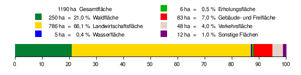
According to data from the State Statistical Office , as of 2014.
history

By the end of the 18th century
Ottenbach was first mentioned in a document in 1275 in the tax register liber decimationis of the Diocese of Constance . It is believed that the place was initially one of the family estates of the Staufer .
In the following centuries Ottenbach was ruled mainly by the Rechbergers , individual farms but also by various other secular and clerical authorities, including the House of Württemberg , which introduced the Reformation for its subjects in the 16th century via the Lorch monastery . The monastery administration Oberhofen bei Göppingen and the Counts of Degenfeld had other rulership rights on the site .
Since the 19th century
In 1806 Ottenbach fell to the Kingdom of Württemberg and was assigned to the Oberamt Göppingen . For a short time Ottenbach was part of the then independent community Hohenstaufen .
Ottenbach has been an independent municipality since 1825.
During the administrative reform during the Nazi era in Württemberg , Ottenbach came to the Göppingen district in 1938.
In 1945 the place became part of the American zone of occupation and thus belonged to the newly founded state of Württemberg-Baden , which was incorporated into the current state of Baden-Württemberg in 1952.
On August 1, 1971 Ottenbach received an area with almost 150 inhabitants from Hohenstaufen. These are the residential areas Cyriakushof, Geyrenwald, Herbenhof, Holzhäuser Hof, Jackenhof, Lochhof, Saurenhof, Schurrhof, Sonnentalhof and Srtudelhof.
Name of the parish
It is still not clear where the name “Ottenbach” comes from. It is believed that it is derived from "Aucht", which means "night pasture".
Population development
- 1825: 362 inhabitants
- 1945: 650 inhabitants
- 1950: 982 inhabitants
- 1966: 1401 inhabitants
- 1980: 2090 inhabitants
- 1987: 2084 inhabitants
- 1991: 2223 inhabitants
- 1995: 2306 inhabitants
- 2005: 2474 inhabitants
- 2010: 2443 inhabitants
- 2015: 2463 inhabitants
Source: State Statistical Office BW
politics
Municipal council
The Ottenbach municipal council consists of 12 members. In the local elections on May 26, 2019 , the local council was elected by majority vote. Majority voting takes place if no or only one nomination has been submitted. The applicants with the highest number of votes are then elected. The municipal council consists of the voluntary councilors and the mayor as chairman. The mayor is entitled to vote in the municipal council.
mayor
- Bernhard Eisele: 1913–1924
- Karl Weber: 1925-1946
- Adolf Sonnentag: 1946–1966
- Bernhard Frick: 1966–2002
- Oliver Franz: since 2002
coat of arms
|
|
Blazon : "Half a red roebuck in gold over a lowered blue wavy bar." |
| Justification of the coat of arms: The roebuck is said to refer to both the Roe Mountains and the von Rechberg family, to which Ottenbach once belonged. The coat of arms becomes "talking" through the wavy bar . The colors red and gold come from the Rechberg coat of arms. A first draft of the coat of arms with half a roebuck in a gold shield was submitted by the archives department of the municipality as early as 1931.The flag is red and yellow. |
religion
After the Reformation, Ottenbach remained Catholic into the 20th century.
Catholic Church
Protestant church
Most of the Protestant residents who moved there only after the Second World War were initially assigned to the Hohenstaufen Protestant parish. Ottenbach has been part of the Eislingen Christ Church Community since 2015. Since then, the name of the community has been Evangelical Christ Church Community Eislingen-Ottenbach . In the 1990s, a farmhouse was converted into a Protestant parish hall.
Sports
Ottenbach became known nationwide through the organization and implementation of the “Alb-Extrem” cycling marathon . The tour takes place every year on the last Sunday in June and leads through the landscape of the Swabian Alb with many climbs. There are several routes to choose from, from the beginners' route "Alb-e @ sy" with 90 km and 1500 hm to the "Traufkönig Ultramarathon" with 300 km and 6000 hm.
The Ottenbach New Year's Eve run over distances of 10 and 6.5 kilometers is organized annually on New Year's Eve by TSV Ottenbach.
Economy and Infrastructure
traffic
Ottenbach does not have a train station, but is integrated into the Filsland bus network via bus line 6, which comes to several stops in Ottenbach. As a municipality in the partially integrated VVS district of Göppingen, the municipality of Ottenbach is also part of the VVS.
education
There is a primary school in Ottenbach , all secondary schools can be found in surrounding communities or cities. There is a Hauptschule with Werkrealschule in Salach , Realschulen and Gymnasien in Eislingen and Göppingen .
Sons and daughters of the church
- Bruno Klaus (1848–1915), teacher and local history researcher, honorary citizen of Schwäbisch Gmünd
- Arthur Mayer (1911-1998), psychologist
Others
Ottenbach is often called the "valley of love" in the area.
literature
- Bernardin Schellenberger : Between Rechberg and Staufen: Ottenbach and the valley of the farms. Anton H. Konrad, Weißenhorn 2002. ISBN 3-87437-465-3
- 700 years of Ottenbach: 1275–1975; a journey through the centuries. Overall editor: Josef W. Hauser. Ottenbach: Community, 1975
- Karl Schönweiler: It was like a wall - effects of the Reformation in the Ottenbacher Tal 1534-2017 , Manuela Kinzel Verlag 2018. ISBN 978-3-95544-115-9
Web links
Individual evidence
- ↑ State Statistical Office Baden-Württemberg - Population by nationality and gender on December 31, 2018 (CSV file) ( help on this ).
- ^ The state of Baden-Württemberg. Official description by district and municipality. Volume III: Stuttgart District, Middle Neckar Regional Association. Kohlhammer, Stuttgart 1978, ISBN 3-17-004758-2 . Pp. 308-309
- ↑ State Statistical Office, area since 1988 according to actual use for Ottenbach.
- ↑ Eberhard Gönner and Heinz Baruda: Book of arms of the district of Göppingen . Ed .: District of Göppingen and Archive Directorate Stuttgart. Verlag W. Kohlhammer, Stuttgart 1966.
- ^ Website of the Evangelical Church Community Eislingen-Ottenbach
- ↑ Evangelisches Gemeindehaus Ottenbach see [1] - last accessed on April 15, 2020
- ↑ Routes and route map: MRSC-Ottenbach. Retrieved February 28, 2019 .
- ↑ http://www.ottenbach.de/index.php?id=44
- ↑ http://www.stauferland.de/orte-im-stauferland/orte-g-bis-o/ottenbach.html
- ↑ http://www.swp.de/geislingen/lokales/landkreis_gp/private-feuerwerke-sind-kuenftig-verboten-13882848.html

Adelberg | Aichelberg | Albershausen | Bad Boll | Bad Ditzenbach | Bad Ueberkingen | Birenbach | Böhmenkirch | Börtlingen | Deggingen | Donzdorf | Drackenstein | Dürnau | Ebersbach an der Fils | Eislingen / Fils | Eschenbach | Gammelshausen | Geislingen an der Steige | Went to the Fils | Göppingen | Gruibingen | Hattenhofen | Heiningen | Hohenstadt | Cake | Lauterstein | Mühlhausen im Täle | Ottenbach | Rechberghausen | Salach | Schlat | Schlierbach | Cuties | Uhingen | Cheeks | Waschenbeuren | Wiesensteig | Zell under Aichelberg