
Stools
| Stools | ||
|---|---|---|
 The Stuifen seen from Hohenstaufen |
||
| height | 757 m above sea level NHN | |
| location | Baden-Wuerttemberg , Germany | |
| Mountains | Swabian Alb | |
| Coordinates | 48 ° 44 '36 " N , 9 ° 49' 7" E | |
|
||
| Type | Zeugenberg | |
| rock | White Jura | |

The Stuifen is 757 m above sea level. NHN high witness mountain of the Swabian Alb and the highest of the Three Kaiser Mountains .
Mountain description
The Stuifen lies in the area of the municipality of Waldstetten and counts as their local mountain . Together with the Rechberg and the Hohenstaufen it forms the Three Kaiser Mountains . In contrast to the other two Kaiserberge mountains, the Stuifen is not built on, but is almost completely forested. The summit can only be reached on foot.
There is a parking lot for hikers near Wißgoldingen at a height of 544 m .
Up to 1850 the stuifen was still covered by juniper heather . The afforestation was carried out for reasons of flood protection and was completed in 1918.
Stuifenkreuz
In September 2011, a twelve-meter-high wooden cross was erected at a height of 718 m on an open space on the west side of the Stuifen . It faces the other two Kaiser mountains (Rechberg and Hohenstaufen). A lookout point has been created here to the south and west, where there is also a refuge and a barbecue area.
photos

Stuifen seen from the foot of the Rechberg
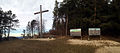
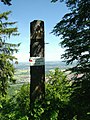
Stuifenkreuz with information boards illustrated by Hans Kloss
At the summit of the Stuifen

The Stuifen, which is not yet completely wooded, around 1912. In the foreground the Reiterleskapelle


