
Rechberg (mountain)
| Rechberg | ||
|---|---|---|
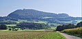
 The Rechberg seen from Hohenstaufen in the west |
||
| height | 708.1 m above sea level NHN | |
| location | Baden-Wuerttemberg , Germany | |
| Mountains | Swabian Alb | |
| Coordinates | 48 ° 45 '24 " N , 9 ° 47' 24" E | |
|
||
| Type | Zeugenberg | |
| rock | White Jura | |

The Rechberg is a south of Schwäbisch Gmünd , 708.1 m above sea level. NHN high Zeugenberg on the northern edge of the Swabian Alb . Together with the Stuifen to the southeast and the Hohenstaufen to the west, it forms the silhouette of the three Kaiserberge mountains that can be seen from afar . The Rechberg has been a state-recognized recreation area since 1979.
geography
The Rechberg rises about 5 km south of the city center of Schwäbisch Gmünd on the boundary of the Rechberg district , which is located with two separate settlement parts at the west and south-east foot of the mountain. This has an approximately long equal-legged ground plan with the base in the east, where the higher Kirchberg with a 1.5–2 ha large open plateau up to 708.1 m above sea level. NHN rises, while the lower spur of the Schlossberg at the pointed corner in the west is only 644.2 m above sea level after a not very deep saddle . Reached NHN . Most of the slopes are wooded.
Coming from the west, the watershed between the river systems of Rems in the north and Fils in the south runs over the spur to the high plateau and bends south here. In the south the Krumm zur Fils drains , in the east the Rechbach and in the northeast the Tobelbach over the Waldstetter Bach to the Rems and in the rest of the north the Tiefenbach with its headwaters Felbenbach and Gießbach further west and down also into this.
Coming from Straßdorf in the north, the L 1159 ascends the lower northern slope of the mountain in a large serpentine and then runs on its middle eastern slope to the larger part of Rechberg at the southeast foot. From there, a road on the southern slope opens up the smaller district in the west and then descends into the valley of the Krumm.
history
The Rechberg has been a destination for pilgrimages since the 15th century. Today, in the middle of the open summit plateau, stands the baroque pilgrimage church of St. Maria , built by Count Bernhard Bero von Rechberg in 1686/88 .
On the western spur of the mountain, the Hohenrechberg ruin rises above the smaller district of Rechberg. This ancestral castle of the later Counts of Rechberg , built at the time of the Hohenstaufen and first mentioned in 1179, was the center of their dominion.
geology
205 million years ago the Jurassic Sea stretched over large parts of what is now southern Germany. In the following 60 million years, about 600 m high Jura sediments were deposited in it, which are divided into lower , middle and upper Jurassic layers. Later the terrain was raised above the sea.
Over time, there were faults, which caused some clods of the harder Upper Jurassic to sink into the softer layers below. While the erosion initially eroded the Upper Jurassic in the immediate vicinity, its sunken parts remained protected. When the erosion subsequently also removed the softer layer, the sunken layers were able to withstand it for longer, which is why they stand prominently above their immediate surroundings in the form of the three Upper Jurassic witness mountains Hohenrechberg, Stuifen and Hohenstaufen ( relief reversal ).
Individual evidence
- ↑ Map services of the Federal Agency for Nature Conservation ( information )
- ^ Rechberg - Ein Heimatbuch , ISBN 3-936373-16-7 , page 9/23.
literature
- Rechberg - A home book: Ortschronik Rechberg, district of Schwäbisch Gmünd . Einhorn-Verlag, Schwäbisch Gmünd 2004, ISBN 3-936373-16-7 .
View from the north
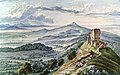
Hohenrechberg Castle , gouache by Louis Mayer, 1836
(Hohenstaufen in the background)
The Rechberg, steel engraving by E. Höfer after E. Mauch, 1841
(in the foreground Straßdorf)
Pilgrimage church on the summit of the Rechberg

The Rechberg seen from Bettringen


