
Rems
| Rems | ||
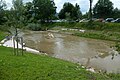
 The Rems shortly before its confluence with the Neckar near Remseck |
||
| Data | ||
| Water code | DE : 23836 | |
| location |
|
|
| River system | Rhine | |
| Drain over | Neckar → Rhine → North Sea | |
| source | near Essingen 48 ° 47 ′ 33 ″ N , 9 ° 59 ′ 41 ″ E |
|
| Source height | 551.4 m above sea level NHN | |
| muzzle |
Neckar near Neckarrems Coordinates: 48 ° 52 '25 " N , 9 ° 16' 29" E 48 ° 52 '25 " N , 9 ° 16' 29" E |
|
| Mouth height | 203.2 m above sea level NHN | |
| Height difference | 348.2 m | |
| Bottom slope | 4.4 ‰ | |
| length | 78.4 km | |
| Catchment area | 586.4 km² | |
| Discharge at the Neustadt A Eo gauge : 567 km² Location: 9 km above the mouth |
NNQ (08.08.1948) MNQ 1923–2009 MQ 1923–2009 Mq 1923–2009 MHQ 1923–2009 HHQ (03.03.1956) |
137 l / s 1.55 m³ / s 6.63 m³ / s 11.7 l / (s km²) 115 m³ / s 265 m³ / s |
| Discharge A Eo : 581.5 km² at the mouth |
MQ Mq |
7.014 m³ / s 12.1 l / (s km²) |
| Right tributaries | Wieslauf | |
| Medium-sized cities | Schwäbisch Gmünd , Schorndorf , Waiblingen | |
 Location of the Rems |
||
The Rems [ ʁɛms ] is a river in Baden-Württemberg . It rises at 551 m above sea level. NHN near the municipality of Essingen near Aalen in the Ostalb district at the foot of the Swabian Alb and flows after about 78 km near Neckarrems in the Ludwigsburg district at 203 m above sea level. NHN from the right into the Neckar .
geography
Rems origin

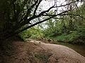
The Remsursprung or the Remsquelle is about 3 km southwest of Essingen at 551.4 m above sea level. NHN next to the L 1165 south of the Hart mountain forest . It is a karst spring designated as a natural monument . The Rems rises from a small opening in the mountainside. The Rems hiking trail begins right at the source.
course
From its origin near Essingen, the Rems flows a short distance north and then heads west. It forms a wide valley and is accompanied by the federal road 29 and the Remsbahn , making the Remstal an important traffic axis from East Württemberg and the neighboring areas of Bavaria to the Stuttgart metropolitan area . After the municipalities of Essingen , Mögglingen and Böbingen , settlement is becoming denser, and commercial and industrial facilities are becoming more numerous. The Rems now reaches the large district town of Schwäbisch Gmünd . After Lorch , the Rems in Waldhausen reaches its point, which has been marked with a stone monolith and a stone circle since 2018 , at which the river has covered half of its way between the source and the mouth. This area was redesigned as the “Rems center” with a view to the Rems Valley Garden Show 2019 .
![]()
Then she changes from the Ostalbkreis to the Rems-Murr-Kreis . Behind Pluederhausen and Urbach they come to the district town Schorndorf , where discharges from right the only major tributary running north from the Welzheimer forest coming Wieslauf . From here you can find vineyards on the valley slopes; the Remstal is one of the largest wine-growing regions in Württemberg . On the river are Winterbach , Remshalden and the town of Weinstadt , which is made up of several localities and is the seat of the Remstalkellerei, the largest winegrowers' cooperative in the Remstal. In addition to vineyards, there are also many fruit- growing areas, especially cherries and apples are cultivated.
Finally the Rems reaches Waiblingen , the administrative seat of the Rems-Murr district. From here on the course and shape of the Rems valley change significantly. While the federal road and the Remsbahn continue straight west in the direction of Stuttgart, the Rems turns to the northwest. From the soft Keuper step it enters the area of the harder shell limestone , the valley becomes narrower and its flanks more rugged. Below Waiblingen-Neustadt it flows past the headquarters of the Stihl chainsaw factory and is crossed by the 239 m long and 45 m high viaduct of the Waiblingen – Schwäbisch Hall-Hessental railway line. Then, with mighty meanders, it enters the Lower Remstal nature reserve . The slopes are mostly forested today; however, some remains of the terrace walls of former vineyards can be seen. The flatter sliding slopes are still used for agriculture. Shortly after crossing into the Ludwigsburg district, the Rems flows into the Neckar near Neckarrems .

Rems origin

At Schwäbisch Gmünd

Rems in downtown Schwäbisch Gmünd after the redesign for the State Garden Show 2014
"Remsmittelpunkt" near Waldhausen
Between Urbach and Schorndorf

In Remshalden

In Neckarrems

It flows into the Neckar in Remseck

Rems hiking trail

map


Tributaries
Selection:
Source of the Rems about 3 km southwest of Essingen .
- Alte Rems , from the right at the Essinger Zollhaus, 3.7 km and 2.9 km².
- Ammersbach , from the right in Mögglingen , 3.4 km and 6.6 km².
- Louder , from the left at Mögglingen train station, 5.1 km and 10.3 km².
- Sulzbach , from the left opposite the Barnberg , 1.1 km.
- Klotzbach or Oberer Mühlbach , from the left below the Remsbrücke of Klotzbachstraße in Böbingen, 8.8 km and 9.0 km².
- Krümmlingsbach or Büchelesbach , from the left near Schwäbisch Gmünd - Zimmer , 5.3 km and 7.2 km².
- Sulzbach from the Schiessal , from the right in central Schwäbisch Gmünd, 5.3 km and 12.5 km².
- Strümpfelbach , on the lower course also Waldstettener Bach after its large left upper course and finally Josefsbach , from the left on the edge of the old town of Gmünd, 13.2 km and 48.5 km².
- Rotenbach , from the right 4.0 km and 4.4 km².
- Tiefenbach from the Hölltal , from the left, 4.3 km and 6.3 km².
- Tannbach or (to the right upper course) also Lichtbach , from the left opposite a courtyard in the Großdeinbach district of Gmünd, 4.6 km and 7.6 km².
- Beutenbach , from the left in Reichenfeld opposite the Lorcher Haldenhof, 6.3 km and 9.8 km².
- Schweizerbach , from the right near Lorch, 10.8 km and 28.4 km².
- Götzenbach , from the right in Lorch, 4.9 km.
- Aimersbach , from the right past the cemetery shortly after the previous one, 5.2 km.
- Walkersbach , from the right to the Lorcher Baggerseen at 273.2 m above sea level. NN , 8.4 km and 17.1 km².
- Schlierbach , from the right at Plüderhausen ( Rems-Murr-Kreis ), 2.7 km.
- Eichenbach , from the left near Plüderhausen, 2.9 km.
- Bärenbach , from the right opposite two small quarry ponds at 255.4 m above sea level. NN , 8.0 km and 16.2 km².
- Urbach , from the right in Urbach at the bridge of the Remsbahn, 8.6 km and 11.0 km².
- Wieslauf , from the right at Schorndorf at 248.2 m above sea level. NN , 23.7 km and 77.2 km².
- Eichenbach , from the left opposite the sports fields between Rems and the Wieslauf- Altlache , 4.8 km.
- Schornbach , from the right in Schorndorf, 6.6 km and 11.1 km².
- Ramsbach , from the right near Schorndorf, 2.9 km.
- Brunnbach , in the lower reaches of Weilerbach , from the left near Winterbach , 3.9 km.
- Lehnenbach , from the left in Winterbach, 4.9 km and 7.1 km².
- Krebsbach , from the right in Winterbach, 2.4 km.
- Mönchsklingenbach , from left to the sewage treatment plant, 2.8 km.
- Schweinbach , from the left before Remshalden-Geradstetten, 2.1 km.
- Lochbach from Lochshau , from the left through Remshalden -Geradstetten an der Rappschen Mühle, 1.7 km.
- Zehntbach , from the right 200 m before the eastern boundary of Grunbach , 2.6 km.
- Grunbach , channeled from the right under Mühlstrasse in Grunbach, 2.8 km and 1.8 km².
- Gundelsbach , from the right at the Weinstadt -Grunbacher driveway onto the B 29, 3.7 km.
- Heppach , from the right below the Großheppacher walkway next to the B 29, 2.8 km and 7.6 km². Runs through an underground canal soon after entering the village.
- Schweizerbach , above also Beutelsbach , from the left between Beutelsbach and Endersbach at its driveway to the B 29, 11.6 km and 35.6 km².
- Haldenbach , from the left near the end of the Birkelstraße in Endersbach, 11.1 km and 26.0 km².
- Beibach , from the left across from the Waiblingen district of Beinstein , 5.6 km.
- Schüttelgraben , from the left in the area of the city of Waiblingen , 5.0 km and 13.8 km².
- Katzenbach , from the right before the town center of Waiblingen, 2.1 km.
- Sörenbach , from the right a few steps afterwards in an underground route, 2.7 km.
- Erbach , from the right through the Fuchsklinge , 3.8 km and 4.3 km².
Mouth of the Rems in from the right Neckar at 203.2 m above sea level. NN after 78.4 km run in the Remseck district of Neckarrems and opposite the district of Neckargröningen.
Cities and municipalities on the Rems
The Rems passes through the following districts and municipalities one after the other:
Usage history
From the Middle Ages onwards, the water of the Rems mainly powered water mills . The mill weirs built for this prevented rafting for a long time . The Wuerttemberg Millers Ordinance from 1627 required the Rems to be made raftable, but it was not until 1715, after the construction of the city and residence of Ludwigsburg , that the obstructing weirs were removed or bypassed with raft lanes in order to bring in the wood used there . From 1723 a lot of logs from the Schorndorfer Forest were floated on the river . In 1747, the entrepreneur Braxmayer, who had built numerous raft lanes, received the raft accord on the Rems for ten years . In order to transport even more wood across the river in this way, rafting lakes were created at four tributaries in the middle of the 18th century , which were dammed in winter, drained at raft time and grazed in summer. The lake on the lower reaches of the Schweizerbach near Lorch was used for rafting on the upper reaches of the Rems above Lorch, which was abandoned in 1826 due to lack of water. The Ebnisee dammed around 1744 was the most important of the Rems raft lakes.
The first wooden garden on the Rems was in Neckarrems ; In 1834 a second was set up in Waiblingen , the turnover of which soon exceeded that of Neckarremser. In the middle of the 19th century, the expansion of the haulage roads made rafting on the Rems unprofitable, so that discussions about ending the Rems rafting altogether were already discussed in the country negotiations of 1849 and the state parliament of 1850. This happened after the Remsbahn opened in 1862.
Todays use
Hydropower

At several former mill locations along the Rems, electricity is now generated from hydropower. Several systems have a fish ladder. The following is a list of the hydropower plants on the Rems in the downstream direction:
- Plüderhausen hydropower plant ( ⊙ 150 kW; drop height: 4.2 m)
- Urbach hydropower plant ( ⊙ 115 kW; drop height: 3.8 m)
- Remshalden-Grunbach hydropower plant ( ⊙ 146 kW; drop height: 3 m)
- Hydroelectric power plant on the Birkel weir in Weinstadt-Endersbach ( ⊙ 140 kW; head: 2.82 m)
- Hydropower plant Beinsteiner Mühle (Geheime Mühle) ( ⊙ 40 kW)
- Hahn'sche Mühle hydropower plant in Waiblingen ( ⊙ 30 kW)
- Häckermühle hydropower plant in Waiblingen ( ⊙ 140 kW; drop height: 3.5 m)
- Hegnacher Mühle ( ⊙ 40 kW; height of fall: 2.3 m)
- Remsmühle hydropower plant (Vogelmühle) ( ⊙ 35 kW)
- Schiedt'sche Mühle in Neckarrems ( ⊙ )
![]() Map with all coordinates: OSM | WikiMap
Map with all coordinates: OSM | WikiMap
leisure
The rowing club in Waiblingen uses an approximately 1.8 km long section of the Rems below the Beinsteiner Mühle as a rowing route. A signposted cycle path runs along a large part of the river.
As part of the Remstal Garden Show 2019 , the Rems was renatured in many places , new accesses to the water created and the river made visible from paths.
Flood protection

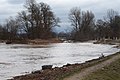
The water level reached at Schorndorf on March 21, 2002 with 512 centimeters and on January 13, 2011 with 522 centimeters historical highs; the statistically 100-year water level is 521 centimeters. The floods of 2002 caused damage of 40 million euros between Remshalden and Waiblingen.
The Rems water association has developed a concept for flood protection, which primarily provides for the construction of flood retention basins . In the years 2002 to 2008 the retention basins Schorndorf-Winterbach , Reichenhof / Schwäbisch Gmünd and Lorch-Waldhausen were built, another one is planned between Plüderhausen and Urbach.
The 2011 floods did not result in any flooding in the Rems Valley. Its main cause was the inflow from the Wieslauf, which flows into the middle reaches in Schorndorf. In the course of this, the Schorndorf-Winterbach retention basin was almost completely flooded, but the Lorch-Waldhausen retention basin above was only flooded by the hour.
Critics of the flood concept - including the Federation for Environment and Nature Conservation Germany - complain that especially surface sealing increases and worsens the floods and that they are not being resisted. According to estimates by the state from 2006, the settlement area in the Rems Valley will increase by a further 14% by 2014.
In order to achieve the goals of the EU Water Framework Directive and to promote ecological development, the state of Baden-Württemberg initiated a natural remodeling of the Rems over a length of 1.1 km between Winterbach and Remshalden-Geradstetten as a water structure measure in 2017/2018.
ecology
The Rems forms an important habitat for animals. The kingfisher is native to Waiblingen on the Rems . The Lower Remstal nature reserve is located on the lower reaches .
Remstal Garden Show 2019
From May 10 to October 20, 2019, a green project of the state of Baden-Württemberg took place in Remstal . These "small" garden shows alternate annually with the state garden shows. Sixteen municipalities took part in this garden show.
photos
High water mark in Schwäbisch Gmünd from 1827

High water mark in Schwäbisch Gmünd from 1912
Flood January 14, 2019

Renaturation between Winterbach and Remshalden


See also
- List of the tributaries of the Rems
- Remstal
- Remstal Garden Show 2019
- Württemberg Wine Route
- List of the tributaries of the Neckar
Individual evidence
- ↑ Height indicated in black on the TK25.
- ↑ The height indicated in blue on the TK25.
- ↑ River water map LUBW-FG10, see the web links.
- ↑ According to LUBW-BRSWEB, rubric water → catchment areas → aggregated areas 04.
- ^ German Hydrological Yearbook Rhine Region, Part I 2009 State Institute for Environment, Measurements and Nature Conservation Baden-Württemberg, p. 118, accessed on January 22, 2016 (PDF, German, 1.85 MB).
- ↑ Expansion potential of hydropower up to 1,000 KW in the Neckar catchment area, taking into account ecological management goals (PDF, 2.0 MB), Ministry for the Environment, Climate Protection and the Energy Sector Baden-Württemberg, May 2011, p. 8, accessed on January 31, 2016.
- ↑ Information board at the origin of Rems.
- ↑ Brief description of the Rems hiking trail on the website of the Swabian Alb Association
- ↑ Sometimes also Aichenbach , flows past the Aichenbachhof . TK25 and LUBW-FG10 uniformly label with Eichenbach .
- ↑ Labeling on TK25 in front of the settlement boundary , on LUBW-FG10 Bücklensweilerbach , perhaps after the Bücklensweilerweg in the immediately following settlement, next to which it runs. Even before the settlement boundary , the geodata viewer has won Buckenweiler .
- ^ Administrative report of the Royal. Ministerial Department for Roads and Hydraulic Engineering for the accounting years 1905 and 1906, II. Department, Water Management, Stuttgart 1908, pp. 111–114.
- ^ Frank Ammann: Wasserkraft on the Rems (part 1) . www.feewi.de. April 28, 2010.
- ^ Frank Ammann: Wasserkraft on the Rems (part 2) . www.feewi.de. April 29, 2010.
- ^ Frank Ammann: Wasserkraft on the Rems (part 3) . www.feewi.de. April 30, 2010.
- ^ Frank Ammann: Wasserkraft on the Rems (part 4) . www.feewi.de. April 30, 2010.
- ↑ Flood forecast center Baden-Württemberg: Gauges master data ( Memento of the original from September 29, 2007 in the Internet Archive ) Info: The archive link was inserted automatically and has not yet been checked. Please check the original and archive link according to the instructions and then remove this notice.
- ↑ a b After the flood the tidying up follows, Gmünder Tagespost from January 15, 2011.
- ^ Flood: New dams save the Rems Valley ( Memento from January 17, 2011 in the Internet Archive ), Stuttgarter Zeitung from January 14, 2011.
- ^ Gmünder Tagespost of April 7, 2006.
- ↑ Website of the Remstal Garden Show 2019 .
literature
- "TK25": Topographic map 1: 25,000 Baden-Württemberg North, single-sheet cut the maps No. 7121 Stuttgart North, 7122 Winnenden, 7123 Schorndorf, 7124 Schwäbisch Gmünd North, 7125 Mögglingen, 7126 Aalen, 7223 Göppingen, 7224 Schwäbisch Gmünd South, 7225 Heubach, 7227 Oberkochen (more for valley and catchment area )
- Marco Polo travel guide "Remstal". Ostfildern 2019. ISBN 978-3829729512 .
Web links
- Map of the Rems and its catchment area on: State Institute for the Environment Baden-Württemberg (LUBW) ( information )
-
Geoportal Baden-Württemberg ( information ), especially with the partial maps / layers
- the State Institute for the Environment, Measurements and Nature Conservation Baden-Württemberg (LUBW)
- "LUBW-FG10": River 1: 10,000
- "LUBW-SG10": Standing water 1: 10,000
- "LUBW-GEZG": water catchment areas
- of the State Office for Geology, Raw Materials and Mining of the State of Baden-Württemberg (LGRB)
- "LGRB-GÜK300": Geological overview map 1: 300,000
- the State Institute for the Environment, Measurements and Nature Conservation Baden-Württemberg (LUBW)
- "LUBW-BRSWEB": LUBW data and map service