
Mögglingen
| coat of arms | Germany map | |
|---|---|---|

|
Coordinates: 48 ° 49 ' N , 9 ° 58' E |
|
| Basic data | ||
| State : | Baden-Württemberg | |
| Administrative region : | Stuttgart | |
| County : | Ostalbkreis | |
| Height : | 413 m above sea level NHN | |
| Area : | 10.27 km 2 | |
| Residents: | 4265 (Dec. 31, 2018) | |
| Population density : | 415 inhabitants per km 2 | |
| Postal code : | 73563 | |
| Area code : | 07174 | |
| License plate : | AA, GD | |
| Community key : | 08 1 36 043 | |
| LOCODE : | DE MGW | |
| Address of the municipal administration: |
Zehnthof 1 73563 Mögglingen |
|
| Website : | ||
| Mayor : | Adrian Schlenker | |
| Location of the municipality Mögglingen in the Ostalb district | ||
  |
||

Mögglingen is a municipality in the Ostalbkreis in Baden-Württemberg . It belongs to the East Wuerttemberg region and the edge zone of the European metropolitan region of Stuttgart .
geography


Geographical location
Mögglingen is 398 to 475 meters above sea level in the Virland of the eastern Swabian Alb in the upper Rems valley between the district town of Aalen (11 km in the east) and the town of Schwäbisch Gmünd (13 km in the west).
Neighboring communities
The community borders on Heuchlingen in the north, Essingen in the east, the town of Heubach in the south and Böbingen an der Rems in the west .
Community structure
The municipality of Mögglingen includes the village of Mögglingen, the hamlets of Hermannsfeld and the farms Christenhof, Gollenhof and Sternhof as well as the abandoned villages of Hegeloch, Sulzbach and Stöckach.
Division of space
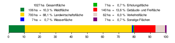
According to data from the State Statistical Office , as of 2014.
history
Mögglingen was first mentioned in a document in 1143 . For a long time the place belonged to the land area of the imperial city Schwäbisch Gmünd . When this fell to the Electorate of Wuerttemberg due to the Reichsdeputationshauptschluss 1803 , Mögglingen also became part of Wuerttemberg. When the new administrative structure was implemented in the Kingdom of Württemberg , which was founded in 1806 , Mögglingen was assigned to the Oberamt Gmünd . During the district reform in Württemberg during the Nazi era , Mögglingen came to the Gmünd district in 1938 . In 1945 the place became part of the American zone of occupation and thus belonged to the newly founded state of Württemberg-Baden , which was incorporated into the current state of Baden-Württemberg in 1952. When the district of Schwäbisch Gmünd was dissolved by the district reform in 1973 , Mögglingen went to the new Ostalb district .
Population development
- 1871: 1003 inhabitants
- 1900: 1058 inhabitants
- 1933: 1443 inhabitants
- 1950: 2150 inhabitants
- 1961: 2564 inhabitants
- 1970: 2933 inhabitants
- 1987: 3316 inhabitants
- 1991: 3567 inhabitants
- 1995: 3728 inhabitants
- 2000: 3884 inhabitants
- 2005: 4167 inhabitants
- 2010: 4165 inhabitants
- 2015: 4173 inhabitants
Christianity
Mögglingen remained Catholic even after the introduction of the Reformation in Württemberg, since most of the estates belonged to citizens and monasteries of the free imperial city of Gmünd, which remained Catholic. The believers are now parish in the Roman Catholic parish of St. Peter and Paul. A Protestant church was only built in 1968. It belongs to the parish of Oberböbingen .

Denomination statistics
According to the 2011 census , 22.0% of the population in 2011 were Protestant , 56.5% were predominantly Roman Catholic and 21.5% were non-denominational , belonged to another religious community or did not provide any information. The number of Protestants and Catholics has fallen since then. Currently (as of June 30, 2019), 20% of the residents are Protestant, 50% Roman Catholic and 30% are non-denominational or belong to another religious community.
politics
Administrative community
The community is a member of the Rosenstein administrative community based in Heubach.
Municipal council
Following the local elections on May 26, 2019, the municipal council has 14 members in addition to the mayor as chairman. The choice brought the following result:
- FUMB (Free and Independent Mögglinger Citizens) 30.16% (−1.80) - 4 seats (± 0)
- Active Mögglinger SPD 27.67% (+7.93) - 4 seats (+1)
- JMB (Young Mögglinger Citizens) 25.45% (+2.83) - 3 seats (± 0)
- CDU 18.52% (−8.96) - 3 seats (−1)
mayor
- 1990–2014: Ottmar Schweizer
- since 2014: Adrian Schlenker. Schlenker was elected in February 2014 in the second ballot with 59.05% of the vote.
coat of arms
Blazon: A black brackish head (brackish head) on a white (silver-colored) background with the tongue hanging out.
Partnerships
Mögglingen has had a partnership with Saleux near Amiens in Picardy in France since 1991 .
Culture and sights
Remstal Garden Show 2019

From May 10 to October 20, 2019, a green project of the state of Baden-Württemberg took place in Remstal , in which Mögglingen is also participating. This Remstal garden show 2019 is one of the "small" garden shows that alternate annually with the state garden shows.
In this context, the Remsufer was redesigned as the "Remsaue" at the inlet of the Lauter . On the hill north of the community west of the Limes parking lot on the state road L1158 towards Heuchlingen was at 370 m above sea level. NHN built an observation tower.
Mögglingen took part in the “16 stations”, the garden show's architectural project, with a “Statue of Liberty”. This represents the Roman goddess Libertas and is reminiscent of the Roman Limes , which used to run north of Mögglingen. But it is also a reminiscence of a scaled-down copy of the New York Statue of Liberty , which for years was a symbol of the Mögglings' desire for a bypass road and which stood on Federal Highway 29 until its completion in spring 2019 . After long arguments with the architect, the Libertas statue was erected west of the observation tower at a remote location on the edge of the forest.
![]()
societies
Around 24 clubs are active in Mögglingen. The strongest members are the Turnverein Mögglingen (1,863 members), the Musikverein Mögglingen (544) and the FC Stern Mögglingen (428).
Economy and Infrastructure
traffic
Regional train trains on the Remsbahn ( Stuttgart - Aalen ) as well as the federal road 29 ( Waiblingen - Nördlingen ) connect Mögglingen with the national transport networks. The next motorway connection is the junction 115 (Aalen / Oberkochen) of the federal motorway 7 , approx. 21 km away on the B 29 towards Aalen and the L 1084. The four-lane Mögglingen bypass on the B 29 was opened on April 27, 2019.
Local public transport is ensured by the OstalbMobil transport cooperation .
Long-distance cycle routes
Several cycle paths cross the municipality:
- The Remstal cycle path accompanies the Rems up to its confluence with the Neckar.
- The German Limes Cycle Route follows the Upper German-Raetian Limes over 818 km from Bad Hönningen on the Rhine to Regensburg on the Danube .
education
With the Limes School , Mögglingen has a primary and secondary school with a technical secondary school . There are also two Roman Catholic kindergartens.
Personalities
Sons and daughters of the church
- Anton Vogt (* 1891, † not known), politician (NSDAP)
People connected to the community
- Carl-Uwe Steeb (* 1967), former tennis professional, grew up in Mögglingen.
- Steffen Dangelmayr (* 1978), soccer player, a. a. at VfB Stuttgart , comes from the youth department of FC Stern Mögglingen
literature
- Karl Eduard Paulus: Mögglingen . In: Description of the Oberamt Gmünd . Verlag Lindemann, Stuttgart 1870 ( full text at Wikisource )
Web links
Individual evidence
- ↑ State Statistical Office Baden-Württemberg - Population by nationality and gender on December 31, 2018 (CSV file) ( help on this ).
- ↑ The town hall is now on the Zehnthof. Mögglingen community, October 15, 2010, accessed on January 20, 2011 .
- ^ The state of Baden-Württemberg. Official description by district and municipality. Volume IV: Stuttgart district, Franconian and East Württemberg regional associations. Kohlhammer, Stuttgart 1980, ISBN 3-17-005708-1 , pp. 731-732.
- ↑ State Statistical Office, area since 1988 according to actual use for Mögglingen.
- ^ Community of Mögglingen Religion , 2011 census
- ↑ Mögglingen in figures , accessed on May 12, 2020
- ↑ http://wahlen11.rz-kiru.de/08136043W/gw2019.html
- ↑ https://remszeitung.de/2014/2/9/buergermeisterwahl-in-moegglingen-adrian-schlenker-gewinnt/
- ↑ Claudia Bell: Feeling strengthened for Fellbach and the Rems Valley. In: Stuttgarter Nachrichten. October 21, 2019, accessed December 24, 2019 .
- ↑ Architecture with 16 stations on remstal.de. Retrieved June 21, 2019.
- ↑ Last chance for the Statue of Liberty . Swabian Post on April 9, 2019.
- ↑ Associations. Mögglingen municipality, accessed on January 20, 2011 .

Basking | Abtsgmünd | Adelmannsfelden | Bartholomä | Böbingen an der Rems | Bopfingen | Durlangen | Ellenberg | Ellwangen (Jagst) | Eschach | Essingen | Göggingen | Gschwend | Heubach | Hypocrites | Hüttlingen | Iggingen | Jagstzell | Kirchheim am Ries | Lauchheim | Leinzell | Lorch | Mögglingen | Mutlangen | Neresheim | Newbie | Obergröningen | Oberkochen | Rainau | Riesbürg | Rosenberg | Ruppertshofen | Schechingen | Schwäbisch Gmünd | Spraitbach | Stödtlen | Panel red | Tannhausen | Unterschneidheim | Waldstetten | Westhausen | Words