
Neresheim
| coat of arms | Germany map | |
|---|---|---|

|
Coordinates: 48 ° 45 ' N , 10 ° 20' E |
|
| Basic data | ||
| State : | Baden-Württemberg | |
| Administrative region : | Stuttgart | |
| County : | Ostalbkreis | |
| Height : | 503 m above sea level NHN | |
| Area : | 118.52 km 2 | |
| Residents: | 7945 (December 31, 2018) | |
| Population density : | 67 inhabitants per km 2 | |
| Postcodes : | 73450, 73441 | |
| Primaries : | 07326, 07362, 07367 | |
| License plate : | AA, GD | |
| Community key : | 08 1 36 045 | |
| LOCODE : | DE NSH | |
| City structure: | 6 districts | |
City administration address : |
Hauptstrasse 20 73450 Neresheim |
|
| Website : | ||
| Mayor : | Thomas Häfele | |
| Location of the city of Neresheim in the Ostalb district | ||
  |
||


Neresheim is a town in the Ostalbkreis in the east of Baden-Württemberg and a state-approved resort.
geography
Geographical location
Neresheim is located in the heart of the Härtsfeld , between Aalen and Nördlingen in the easternmost part of the Swabian Alb . In and near Neresheim, the river Egau has its source in several sources and flows into the Danube after about 40 km near Dillingen .
Neighboring communities
The city borders in the north on the city of Bopfingen and the municipality of Riesbürg , in the east on the Bavarian communities Nördlingen , Ederheim and Forheim , in the south on Dischingen , Nattheim and the city of Heidenheim an der Brenz , all three in the Heidenheim district , and in the west the district town of Aalen .
City structure
The urban area of Neresheim consists of the city center and the municipalities incorporated between 1892 (Neresheim Castle) and 1975 (Ohmenheim). The localities that were incorporated in the 1970s are now districts with their own mayors.
| district | coat of arms | Area in km² | Population (December 31, 2019) |
Sub-locations |
|---|---|---|---|---|
| Neresheim (core town) |
|
23.87 | 3,407 | Stetten , Neresheim Castle , Eichhof, Eichplatte, Gallusmühle, Geißhalde, Lichshöfe, Riegel, Steinmühle, Sägmühle, Härtsfeldwerke |
| Dorfmerkingen |
|
23.45 | 1,022 | Dossingen , Hohenlohe , Weilermerkingen , Hölzleshof, Schlosshof |
| Elchingen on the Härtsfeld |
|
22.56 | 1,592 | Haldenhöfe |
| Kosingen |
|
13.36 | 539 | Hohlenstein, Fluertshäuserhof, Rotenberg |
| Ohmenheim |
|
22.13 | 1,173 | Dehlingen , Maueräcker |
| Schweindorf |
|
13.15 | 247 | Mörtingen |
Division of space

According to data from the State Statistical Office , as of 2014.
history
Until the 19th century
Although the area was settled much earlier, Neresheim was first mentioned in a donation letter in 1095 in connection with the founding of the abbey Neresheim and in 1350 raised to the "place". The territorial affiliation and history of Neresheim coincided with the history of the abbey until secularization in 1803 . In 1634, during the Blood Night of Neresheim in the Thirty Years War , Neresheim only had 250 inhabitants. The city recovered and then developed again. In 1796 French troops occupied Neresheim. A mention of the city in the inscription on the triumphal arch in Paris refers to the battle of Neresheim on August 11, 1796.
From 1803 until mediatization in 1806, Neresheim belonged to the territory of the Princes of Thurn and Taxis . After four years of membership in the Kingdom of Bavaria Neresheim came the due border treaty of 1810 to the Kingdom of Württemberg . The city became the seat of the Oberamt Neresheim with the corresponding facilities such as the district court and prison, and later also a hospital and high school.

20th century
In 1900 the construction of the Härtsfeldbahn between Aalen and Dillingen began with Neresheim as the operating center. The railway was a narrow-gauge railway (meter gauge) and, in addition to passenger traffic, was mainly used to transport wood from the Thurn and Taxis forests surrounding Neresheim and to transport limestone from the quarries. Railway operations were discontinued in 1972; one section was reopened in 2001 as a museum railway.
The Oberamt or, from 1934, the Neresheim district existed until 1938, when Neresheim was assigned to the newly formed Aalen district as part of the administrative reform .
Development of the urban area in the post-war period
After the Second World War, Neresheim fell into the American zone of occupation and thus belonged to the newly founded state of Württemberg-Baden . In 1945 the main town of Neresheim, with a predominantly rural structure, had around 900 inhabitants and had to take in around the same number of refugees. In 1952 Neresheim came to the state of Baden-Württemberg.
With the land consolidation in 1957 and the relocation of almost all farms to the Lichshöfen and Eichplatte, Neresheim began to transform into the “real” town. In 1958, the state government at that time classified Härtsfeld as a redevelopment area (Härtsfeld funding program) and the communities with a focus on Neresheim received extensive funding for their municipal measures. There was a lot of catching up to do with the infrastructure. As a matter of urgency, water supply and sewerage with sewage treatment plants, then schools and sports facilities either had to be newly created or renewed.
Industrial settlements were attempted with moderate success and mostly failed after a few years. Nevertheless, there was brisk construction activity in the Sohl building area outside the town center. Because of its schools, Neresheim became a popular residential destination for commuters from the industrial companies in Heidenheim and Aalen.
Incorporations
Already in 1892 the community of Neresheim Castle was incorporated. Today it is not a separate district, but belongs to the core city.
As part of the regional reform in Baden-Württemberg , the communities Schweindorf and Kösingen were incorporated on January 1, 1971, the Dorfmerkingen community on March 1, 1972, the Elchingen community on May 1, 1972 and the Ohmenheim community on January 1, 1975 . In 1973 the district reform took place in Baden-Württemberg , when Neresheim became part of the Ostalb district.
The town center or the actual main street became deserted and partly fell into disrepair. It was only from 1980 onwards, as part of the urban development funding, through targeted urban renewal , the restoration of the town hall, the redesign of Marienplatz and Marktstrasse, as well as the demolition and renovation of crumbling buildings. This renovation has not yet been completed, but the town center is already being filled with new life. In the meantime, a small settlement of retail chains and shops has formed on the site of the former WAP company in the Härtsfeld Center at the entrance to the village.
Locations left
Lost villages , grouped according to the former municipality on whose territory they were located, are:
- Elchingen: Fachsenberg , Hohensalach and Lebern
- Neresheim: Eschenbach and Marterfelden (?)
- Ohmenheim: Fartesheim, Echenwanc, Hecelesberc, Adellohesberc, Buch, Mittel- or Michelstetten and Sommerhof
Religions
Neresheim is deeply rooted in the Catholic faith and shaped by the Benedictine abbey . Nevertheless, there were a few evangelical families, mainly immigrated as civil servants of the upper office, who first fought hard in the town hall - which therefore has a tower - and later had their own prayer room in the Franzke house (today Zuckermann). The main town has two Catholic churches with the typical onion domes. Until the early 1970s, it was common for the Catholic pastor to go through the town praying through the breviary when visiting the home or the sick and being greeted by the male passers-by by taking off their hats and by the women by kneeling and signing the cross. The sub-towns also have their own Catholic churches and parishes that are deeply rooted in faith. They all belong to the Deanery Ostalb of the Rottenburg-Stuttgart diocese . An exception is the suburb of Schweindorf, which, originally belonging to the Protestant Nördlingen, has always formed a Protestant island on the Härtsfeld with its own church, which also looked after the few Protestant Christians from Neresheim.
With the influx of refugees at the end of the Second World War , the proportion of Protestants rose to 25%. After the initial care by Pastor Wagner from Schweindorf, Neresheim got the Protestant Vicar Eberhard Gaier in 1956, who later built his own church as a pastor with entrepreneurial talent and energy, expanded his parish to other places and the current Samaritan Foundation, which belongs to the Protestant Diakonie, at that time as a brotherhood and sisterhood Haus am Sohl, founded.
The Benedictine monastery always had a seat and vote in the municipal council and had an influence on the politics and development of the place, which meant that the area was only cautious about changes. Today it is a popular, natural recreation area with the monastery as the focus.
politics
Municipal council
In Neresheim, the municipal council is elected using the spurious selection of a part of town. The number of local councils can change due to overhang mandates . After the last election, the municipal council in Neresheim has 18 members (2014: 16). The local election on May 26, 2019 led to the following official final result. The municipal council consists of the elected voluntary councilors and the mayor as chairman. The mayor is entitled to vote in the municipal council.
| Parties and constituencies | % 2019 |
Seats 2019 |
% 2014 |
Seats 2014 |
||
|---|---|---|---|---|---|---|
| CDU | Christian Democratic Union of Germany | 54.50 | 10 | 54.01 | 9 | |
| FW | Free electoral association | 19.10 | 3 | 28.52 | 5 | |
| GREEN | Alliance 90 / The Greens | 16.30 | 3 | - | - | |
| SPD | Social Democratic Party of Germany | 10.20 | 2 | 15.20 | 2 | |
| FB | Free community of citizens | - | - | 2.39 | 0 | |
| total | 100 | 18th | 100 | 16 | ||
| voter turnout | 62.5% | 53.3% | ||||
administration
Thomas Häfele (CDU) has been mayor since January 1, 2018. He succeeded the non-party Gerd Dannenmann. The districts have their own mayors and local councils and participate in the decision-making processes of the entire community in accordance with the municipal code.
coat of arms
The blazon of the coat of arms reads: “Shield divided by gold and red, covered with a blue heart shield, which meets a row of red iron hats at the top and a row of overturned golden iron hats below. On both sides of the heart shield there is a small iron hat, which covers the division and has the tip pointing outwards, in mixed up colors. The coat of arms is covered by a continuous silver ledge. "
The coat of arms is derived from the coat of arms of the County of Oettingen , to which the city belonged until 1806, and is now used in a simplified form.
Coats of arms of the districts

Dorfmerkingen

Elchingen on the Härtsfeld

Kosingen

Ohmenheim

Schweindorf


Town twinning
Neresheim has been in partnership with Steinach am Brenner in Tyrol in Austria since 1976, with the Italian municipality of Bagnacavallo in Emilia-Romagna since 1994 and with the municipality of Aix-en-Othe in northern France since 1996 .
Economy and Infrastructure
traffic
The federal highway 466 runs through the village . About 10 km away there are connections to the A 7 motorway via the Heidenheim and Aalen driveways . There are bus routes to Aalen, Bopfingen, Dischingen and Heidenheim, and the sub-locations are included in this traffic. Until 1972 Neresheim was also connected to the rail network by the Härtsfeldbahn (Aalen– Dillingen ).
Neresheim has a glider airfield on site and, in the Elchingen district, also houses the Aalen-Heidenheim airfield of the Aalen air sports ring with a 950 m long and 25 m wide asphalt runway.

Northwest of Utzmemmingen at 48 ° 49 ′ 48 ″ N , 10 ° 25 ′ 10 ″ E there is a radio beacon with the callsign NDG (transmission frequency: 375 kHz).
Established businesses
The largest local industries are the two companies, Weisser Spulenkörper and Bruno Weisser Kunststoffverarbeitung, founded by Bruno Weisser in 1946, with a total of around 300 employees. Further metal processing companies, craft companies and service companies are located in the two industrial areas in Neresheim and those of the sub-locations.
Court and bodies
Neresheim has a local court with a notary's office , which belongs to the district of Ellwangen and the district of higher regional court of Stuttgart .
The city was the seat of the Catholic deanery Neresheim of the diocese Rottenburg-Stuttgart , which was merged with the deaneries Aalen, Ellwangen and Schwäbisch Gmünd in 2006 to form the deanery Ostalb .
Educational institutions
Härtsfeld School
The Härtsfeldschule Neresheim is a primary, technical and secondary school with approx. 832 students and 69 teachers, who are divided into around 38 classes (2019/2020 school year). In addition to Neresheim, the primary schools in the suburbs of Ohmenheim and Dorfmerkingen also belong to the Härtsfeldschule. The catchment area of the Härtsfeldschule is the entire Härtsfeld.
Benedikt-Maria-Werkmeister-Gymnasium
In addition to the elementary, technical and secondary school, Neresheim has a grammar school with a long tradition. Although Neresheim only had a few hundred inhabitants at that time and for a long time afterwards, it was given a secondary school as the Oberamtsstadt in 1846, which later called itself a high school for boys, then was a Progymnasium without an upper level until 2006, has been a full high school since 2004 and is now called Benedikt -Maria-Werkmeister-Gymnasium carries.
The catchment area is still the entire Härtsfeld, the individual class sizes are manageable with around 332 students in total at the grammar school, distributed over 16 classes (school year 2019/2020). In the 2008/2009 school year there were still around 450 students, spread over 19 classes.
Specialist hospital SRH
The SRH Fachkrankenhaus Neresheim , which emerged from the former district hospital, is a neurological-neurosurgical specialist clinic for early / rapid care and rehabilitation of people with severe brain damage - e.g. B. after accidents or sudden cerebral hemorrhage.
Samaritan pen
Originally founded as a brotherhood and sisterhood Haus am Sohl by the Neresheim pastor Gaier, the monastery in Neresheim with over 300 employees today belongs to the social enterprise Samariterstiftung of the Protestant Diakonie in Baden-Württemberg.
The house in Neresheim has a capacity of around 90 places for elderly and short-term care and around 140 places for mutually supportive people with disabilities in largely autonomous outdoor living groups. Another focus is the care of the handicapped with four workshops for more than 450 people with disabilities.
Culture and sights
Museums
- The Härtsfeld Museum offers insights into the cultural development of the Härtsfeld.
- The Härtsfeldbahn Museum in the old station shows the history of the Härtsfeldbahn .
- The town hall has been restored and restored to its former state with vaults and access to dungeons and can be visited.
- A former city fountain was uncovered in Marktstrasse, just as the Egau springs were captured and made accessible.
- At the cemetery part of the former city wall has been restored.

Härtsfeldmuseum with the back of the town hall
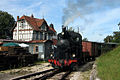
Museum train in front of the station


Buildings
An outstanding attraction is the Neresheim Abbey, founded in 1095 . The monastery church was designed by Balthasar Neumann and is one of the largest baroque hall buildings in southern Germany. In the church there are dome frescos by the church painter Martin Knoller from Steinach am Brenner in Tyrol. The main organ of the abbey church was built in 1792–1797 by Johann Nepomuk Holzhey from Ottobeuren.

Neresheim Abbey Church
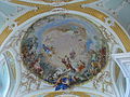
Dome fresco v. Knoller
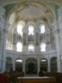
Holzhey organ


More evidence of past eras of the place and the neighborhood are Schloss Taxis , the castle Katzenstein , the Kapfenburg and the two ruins high and low house Kartäusertal .
Like the main town, individual sub-towns have their own churches with elaborate frescoes, paintings and elaborate altar decorations. The oldest building in Neresheim is likely the Vogt- und Schießhaus, which was rebuilt in 1531 after a fire and today houses the Härtsfeld Museum. The town hall next to it, the age of which is not so certain, is mentioned from 1405 and is said to have at least been rebuilt in 1640. It also served as a grain transhipment point (Schranne). The high pitched roof has four floors for grain storage. The Protestant parish, which had a prayer hall in the building for a long time, put a pointed bell tower on the roof in 1893. After the bell has found a place in the new Protestant church, there is a carillon of 18 bells in the tower, from which folk tunes can be heard three times a day, automatically or manually.

Outside the old town center you can find the former tithe barn from around 1600, which is now in private hands and cannot be used for any other purpose due to unclear monument protection requirements. Directly next to it is the former post office from 1911 , which is also a listed building, with the characteristic copper spire, which is also in private hands.
Regular events
- Historic steam train rides on the Härtsfeldbahn
- Historical city festival at the end of June
- Concerts in the Neresheim Abbey Church
- Every even year there is a big carnival parade in the Kösingen district
fire Department
The city of Neresheim maintains the volunteer fire department with six departments and a youth fire department . Each village has its own fire station .
Sports
Sports facilities
In Neresheim there is an indoor pool, an outdoor pool, and a triple sports hall for school and club sports. A sports facility with a 400-meter arena and other facilities is available for athletics and football. Other sports facilities are owned by clubs such as golf, tennis, shooting and riding facilities. Some of the districts have their own sports fields, outdoor and / or indoor swimming pools and gymnasiums and festival halls, as have their own sports clubs.
The Härtsfeldsee offers opportunities for swimming, surfing and boating.
Soccer
The footballers of Sportfreunde Dorfmerkingen play in the Oberliga Baden-Württemberg . In the 1998/99 season he qualified for participation in the first DFB Cup main round by winning the WFV Cup .
The greatest success of the Kösinger Sport Club (KSC) was the promotion to the district class. But things have gone downhill since then. After giving up important players, he was relegated to the district class B.
The SV Neresheim rose in the 2008/2009 season in the district league A.
Gliding
Since 1954, Neresheim has had a glider club with its own space and infrastructure (hall, accommodation and workshops) on the former parade ground in Fleinersloh south of the city.
Personalities
Honorary citizen
- Karl Ludwig Wilhelm Lang (1852–1914), awarded in 1892
- Gottlieb Immanuel Marschall (1840–1905), awarded in 1896
- Kaspar Vogler (1830–1910), awarded in 1901
- Hugo Präg (1868–1936), awarded in 1928
- Bernhard Durst (1882–1966), awarded in 1957
- Adalbert Seifriz (1902–1990), awarded in 1962
- Otto Häfele (1896–1978), awarded in 1967
- Johann Kraus (1904–1977), awarded in 1977
- Erich Ganzenmüller (1914–1983), awarded in 1977
- Anton Hegele (1917–1992), awarded in 1985
sons and daughters of the town
- Carl Friedrich Klein (1803–1884), born in Schweindorf, textile manufacturer
- Karl von Hohl (1825–1899), born in Ohmenheim, lawyer and politician
- Joseph von Eisenbarth (1844–1913), born in Dehlingen, Catholic clergyman
- Oscar Mayer (1859–1955), born in Kösingen, sausage manufacturer in the USA
- Karl Bonhoeffer (1868–1948), psychiatrist and neurologist, father of Dietrich Bonhoeffer
- Otto Gauß (1877–1970), born in Dorfmerkingen, organist and composer
- Julius von Jan (1897–1964), born in Schweindorf, pastor of the Confessing Church and resistance fighter against National Socialism
- Adalbert Seifriz (1902–1990), CDU politician
- Helmut Weihenmaier (1905–1995), district administrator and mayor of Tübingen
- Hans Mendler (* 1950), painter
- Bernhard Huber (* 1964), glass painter, installation artist
- Andreas Zeyer (* 1968), soccer player (including Heidenheimer SB, SSV Ulm, SC Freiburg, VfL Bochum, Hamburger SV)
- Michael Zeyer (* 1968), soccer player (including Heidenheimer SB, SC Freiburg, 1. FC Kaiserslautern, MSV Duisburg, VfB Stuttgart, Fortuna Düsseldorf)
- Margarete Huber , composer, concert and opera singer
Personalities who worked in Neresheim
- Norbert Stoffels (1936–2013), Dept.
- Hugo Weihermüller , organist at Neresheim Abbey, artist
- Brigitte Wilhelm (* 1939), sculptor
literature
- Gerd Dannenmann (Ed.): Neresheim, the Härtsfeldstadt. Neresheim 2000, ISBN 3-9806438-3-2 .
Web links
Individual evidence
- ↑ State Statistical Office Baden-Württemberg - Population by nationality and gender on December 31, 2018 (CSV file) ( help on this ).
- ↑ a b The state of Baden-Württemberg. Official description by district and municipality. Volume IV: Stuttgart district, Franconian and East Württemberg regional associations. Kohlhammer, Stuttgart 1980, ISBN 3-17-005708-1 , pp. 763-768.
- ↑ a b c Annual report 2019 of the city of Neresheim
- ↑ State Statistical Office, area since 1988 according to actual use for Neresheim.
- ↑ Neresheim Monastery on LEO-BW
- ^ Federal Statistical Office (ed.): Historical municipality directory for the Federal Republic of Germany. Name, border and key number changes in municipalities, counties and administrative districts from May 27, 1970 to December 31, 1982 . W. Kohlhammer, Stuttgart / Mainz 1983, ISBN 3-17-003263-1 , p. 445 and 471 .
- ↑ http://www.pgn.aa.bw.schule.de/
Dorfmerkingen with Dossingen , Hohenlohe and Weilermerkingen | Elchingen on the Härtsfeld | Kösingen with Hohlenstein | Neresheim (city center) with Neresheim Castle and Stetten | Ohmenheim with Dehlingen | Schweindorf with Mörtingen

Basking | Abtsgmünd | Adelmannsfelden | Bartholomä | Böbingen an der Rems | Bopfingen | Durlangen | Ellenberg | Ellwangen (Jagst) | Eschach | Essingen | Göggingen | Gschwend | Heubach | Hypocrites | Hüttlingen | Iggingen | Jagstzell | Kirchheim am Ries | Lauchheim | Leinzell | Lorch | Mögglingen | Mutlangen | Neresheim | Newbie | Obergröningen | Oberkochen | Rainau | Riesbürg | Rosenberg | Ruppertshofen | Schechingen | Schwäbisch Gmünd | Spraitbach | Stödtlen | Panel red | Tannhausen | Unterschneidheim | Waldstetten | Westhausen | Words