Kartäusertal
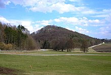
The Kartäusertal (also Karthäusertal) is located on the southwestern edge of the Ries near Ederheim and Hürnheim in Swabia . The castle -lined forest valley is now a popular local recreation area in the cities of Nördlingen and Donauwörth .
The center and namesake is the former Carthusian monastery Christgarten . The Gothic choir of the monastery church has been preserved, the nave was demolished in the 19th century except for the remains of the wall.
Actually, only the subsequent section of the valley up to the Karlshof domain is called the Kartäusertal . To the northeast is the valley of the trout stream with the powder mill and the Niederhaus castle ruins . The name "Carthäusertal" was originally only used for the westernmost part between the Weiherberg and the Vogelsberg .
The castles
In addition to the scenic beauty and the monastery with its restaurant, the two castle ruins, Niederhaus and Hochhaus, are particularly attractive for the numerous hikers. The other marginal heights of the valley, which is only about four kilometers long, also bear the remains of former fortifications.
To the east of Christgarten lies the high medieval Rauhaus castle stable on a hill.
To the south behind the monastery there is a prehistoric section fortification on the Weiherberg and a small, probably medieval fortification on the northeast edge of the ridge.
The small castle on the Mühlberg in the east was probably also the birg of a Carolingian manor in the valley .
Above the hamlet of Anhausen, the Hagburg ramparts and the Hochhaus castle on the Hochhauser Berg guard the exit of the valley. The Hagburg is interpreted as another Birg, but it also has the characteristics of a Hungarian protective castle. Possibly it is to be seen as the outworks of the large castle on the Weiherberg, especially since the high-rise castle opposite was built in the middle of extensive section fortifications .
The high-rise castle ruins themselves are now in great danger of collapsing, and entry is officially prohibited.
Finally, the Niederhaus ruin towers over the side valley of the trout stream. The renovated castle ruins are surrounded by a strikingly deep, double wall system. Such elaborate moat systems point to early medieval predecessor systems. It is possible that this castle site was also part of a larger Hungarian fortress system around the Weiherberg.
literature
Hans Frei, Günther Krahe: Archaeological walks in the Ries (guide to archaeological monuments in Bavaria, Swabia, 2). Stuttgart, 1979, ISBN 3-8062-0230-3 .
References
- ↑ Otto Schneider, Kurt Böhner ; see. Hagburg
Coordinates: 48 ° 47 ′ 6 " N , 10 ° 28 ′ 26.4" E


