
Ederheim
| coat of arms | Germany map | |
|---|---|---|

|
Coordinates: 48 ° 49 ' N , 10 ° 28' E |
|
| Basic data | ||
| State : | Bavaria | |
| Administrative region : | Swabia | |
| County : | Danube Ries | |
| Management Community : | Ries | |
| Height : | 469 m above sea level NHN | |
| Area : | 16.57 km 2 | |
| Residents: | 1138 (Dec. 31, 2019) | |
| Population density : | 69 inhabitants per km 2 | |
| Postal code : | 86739 | |
| Area code : | 09081 | |
| License plate : | DON, Lower Austria | |
| Community key : | 09 7 79 136 | |
| LOCODE : | DE EDH | |
| Community structure: | 10 parish parts | |
| Association administration address: | Beuthener Str. 6 86720 Nördlingen |
|
| Website : | ||
| Mayoress : | Petra Eisele (Women's Youth SPD ) | |
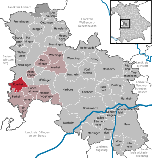
| Location of the municipality of Ederheim in the Donau-Ries district | ||
  |
||


Ederheim is a municipality in the Swabian district of Donau-Ries and a member of the Ries administrative community based in Nördlingen .
geography
Ederheim is located on the southern edge of the Nördlinger Ries and is part of the Augsburg planning region .
The municipality has ten officially named municipal parts (the type of settlement is indicated in brackets ):
|
|
There are the districts of Christgarten, Ederheim and Hürnheim.

history
Until the church is planted
Ederheim was first mentioned in the 8th century in connection with donations from Frankish kings to the Fulda monastery . The Lords of Hürnheim already held the right of patronage in Ederheim before 1273 . The later rule of the Counts of Oettingen was since 1751 an office of the Landkommende Ellingen ( Ballei Franken ) of the Teutonic Order . With the Rhine Confederation Act 1806, the place came to the Kingdom of Bavaria . Although the German order de jure was not abolished until 1809, Bavaria had already sequestered the possessions of the order in the course of mediatization (1805/1806).
During the era of the County of Oettingen , Ederheim was part of the Swabian Empire from 1500 onwards , with the transition to the Teutonic Order the change to the Franconian Empire took place .
Incorporations
On May 1, 1978, the previously independent communities of Christgarten and Hürnheim were incorporated.
Population development
Between 1988 and 2018 the municipality grew from 1,020 to 1,143 by 123 inhabitants or by 12.1%.
- 1961: 891 inhabitants
- 1970: 943 inhabitants
- 1987: 1005 inhabitants
- 1991: 1088 inhabitants
- 1995: 1096 inhabitants
- 2000: 1125 inhabitants
- 2005: 1149 inhabitants
- 2010: 1128 inhabitants
- 2015: 1122 inhabitants
politics
mayor
- until 2008: Karl-Heinz Stegmeier (Free Voting Association)
- 2008–2020: Caroline Zehnpfennig-Doleczik (Free Voting Association Ederheim)
- from 2020: Petra Eisele (Women's Youth SPD)
Municipal council
The municipal council consists of twelve members. In 2002 it was composed as follows:
- Free community of voters 6 seats
- Voluntary voter community Hürnheim 3 seats
- Women's youth SPD 3 seats
Even after the 2020 election, the municipal council has 12 members. In the 2020 to 2026 term of office , the 12 seats are divided between WGE (5), FJ-SPD (4) and WGH (3).
coat of arms
|
|
Blazon : "In silver a continuous black paw cross, applied a red deer antler" |
Architectural monuments
Economy and Infrastructure
Economy including agriculture and forestry
In 2010, according to official statistics, there were 148 employees subject to social security contributions at the place of work, 108 of them in the manufacturing sector. There were a total of 409 employees at the place of residence subject to social insurance contributions. There were 17 farms. The area survey shows 599 ha of agricultural area and 898 ha of forest.
education
The following institutions exist (as of 2011):
- Kindergarten: 60 kindergarten places with 42 children
- Ederheim primary school
Personalities
- Elias Ehinger (1573–1653), born in Christgarten, Protestant theologian, educator, librarian and philologist
See also
Web links
Individual evidence
- ↑ "Data 2" sheet, Statistical Report A1200C 202041 Population of the municipalities, districts and administrative districts 1st quarter 2020 (population based on the 2011 census) ( help ).
- ↑ Municipal Council. Ederheim municipality, accessed on June 11, 2020 .
- ^ Community Ederheim in the local database of the Bavarian State Library Online . Bayerische Staatsbibliothek, accessed on September 2, 2019.
- ↑ a b c Federal Statistical Office (ed.): Historical municipality directory for the Federal Republic of Germany. Name, border and key number changes in municipalities, counties and administrative districts from May 27, 1970 to December 31, 1982 . W. Kohlhammer, Stuttgart / Mainz 1983, ISBN 3-17-003263-1 , p. 793 .
- ↑ http://www.ederheim.de/html/gemeinderat.html
- ^ Entry on the coat of arms of Ederheim in the database of the House of Bavarian History

Alerheim | Amerdingen | Asbach-Bäumenheim | Auhausen | Buchdorf | Daiting | Deiningen | Donauwörth | Ederheim | Ehingen am Ries | Forheim | Fremdingen | Fünfstetten | Genderkingen | Hainsfarth | Harburg (Swabia) | Hohenaltheim | Holzheim | Huisheim | Kaisheim | Maihingen | Marktoffingen | Marxheim | Megesheim | Mertingen | Mönchsdeggingen | Monheim | Möttingen | Munningen | Munster | Niederschönenfeld | Nordlingen | Oberndorf am Lech | Oettingen in Bavaria | Otting | Rain | Reimlingen | Rögling | Tagmersheim | Tapfheim | Wallerstein | Wechingen | Wemding | Wolferstadt
Unregulated areas: Dornstadt-Linkersbaindt | Ester wood