
Marktoffingen
| coat of arms | Germany map | |
|---|---|---|

|
Coordinates: 48 ° 55 ' N , 10 ° 28' E |
|
| Basic data | ||
| State : | Bavaria | |
| Administrative region : | Swabia | |
| County : | Danube Ries | |
| Management Community : | Wallerstein | |
| Height : | 441 m above sea level NHN | |
| Area : | 13.6 km 2 | |
| Residents: | 1311 (December 31, 2019) | |
| Population density : | 96 inhabitants per km 2 | |
| Postal code : | 86748 | |
| Area code : | 09087 | |
| License plate : | DON, Lower Austria | |
| Community key : | 09 7 79 177 | |
| Community structure: | 5 parts of the community | |
| Association administration address: | Weinstrasse 19 86757 Wallerstein |
|
| Website : | ||
| Mayor : | Helmut Bauer | |
| Location of the municipality of Marktoffingen in the Donau-Ries district | ||
  |
||


Marktoffingen is a municipality in the Swabian district of Donau-Ries and a member of the Wallerstein administrative community .
geography
Marktoffingen is located in the Nördlinger Ries and is part of the Augsburg planning region .
The municipality has five officially named municipal parts (the type of settlement is given in brackets ):
- Marktoffingen ( parish village )
- Minderoffingen (parish village)
- Ramstein ( wasteland )
- Schnabelhöfe (wasteland)
- Wengenhausen ( hamlet )
There are the districts of Marktoffingen and Minderoffingen.
history
Until the church is planted
Since the first half of the 13th century, the place was owned by the Counts of Oettingen as a fief of the Augsburg Cathedral Chapter , most recently on the Oettingen-Wallerstein line. Marktoffingen has been an office since 1500, later the upper office with its own high jurisdiction of the Principality of Oettingen-Wallerstein. With the Rhine Confederation Act 1806, the place came to the Kingdom of Bavaria .
Incorporations
The municipality of Minderoffingen was incorporated into the municipality of Marktoffingen on May 1, 1978 as part of the regional reform .
Population development
Between 1988 and 2018 the municipality grew from 1,265 to 1,311 by 46 inhabitants or 3.6%.
- 1961: 1039 inhabitants
- 1970: 1085 inhabitants
- 1987: 1238 inhabitants
- 1991: 1295 inhabitants
- 1995: 1313 inhabitants
- 2000: 1371 inhabitants
- 2005: 1358 inhabitants
- 2010: 1310 inhabitants
- 2015: 1297 inhabitants
politics
mayor
Helmut Bauer (Independent Voting Association Marktoffingen) has been mayor since May 1, 2014; he was confirmed in office on March 15, 2020 with 92.3% for a further six years.
Municipal council
In the local elections on March 15, 2020 , the Independent Voting Association Marktoffingen received 66.6% of the votes and received 8 municipal council mandates. The free voters in Minderoffingen received 33.4% of the vote and have 4 municipal councils.
Architectural monuments
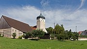
Marktoffingen, the Catholic parish church of the Assumption

Wengenhausen, the Catholic Marienkapelle
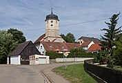
Minderoffingen, the Catholic parish church of Sankt Laurentius


Economy and Infrastructure
Economy including agriculture and forestry
In 2017, according to official statistics, there were 73 employees subject to social insurance contributions at the Marktoffingen location. There were 572 employees subject to social security contributions at the place of residence. This means that the number of out-commuters was 499 higher than that of in-commuters. 17 residents were unemployed. In 2016 there were 39 farms; In 1999 the community still had 65 companies. 1710 hectares of the municipal area were used for agriculture, of which 271 hectares of permanent grassland and 1439 hectares of arable land.
traffic
The Marktoffingen stop is on the Nördlingen – Dombühl railway line . Seasonal special trips of the Bavarian Railway Museum take place here in summer .
nature
The Wengenhausen Impact Rocks quarry is located northwest of Wengenhausen . The quarry is designated as a geotope and is one of the 100 most beautiful geotopes in Bavaria.
education
In 2018 there were the following institutions:
- 1 day care center with 62 places and 38 visitors, including four children under three years of age
- 1 elementary school with five classes, five teachers and 98 students
Sons and daughters of the church
- Philipp Anton von Müller, French Antoine de Muller (1788–1859), cellar master at the Veuve Clicquot Ponsardin champagne house in Reims from 1810 to 1822
- Alban Haas , theologian and local historian
literature
- Josef Th. Groiß (Ed.): On the history of the communities of Marktoffingen and Minderoffingen 1143–1993. Marktoffingen 1993.
Web links
- Entry on the coat of arms of Marktoffingen in the database of the House of Bavarian History
Individual evidence
- ↑ "Data 2" sheet, Statistical Report A1200C 202041 Population of the municipalities, districts and administrative districts 1st quarter 2020 (population based on the 2011 census) ( help ).
- ^ Community of Marktoffingen in the local database of the Bavarian State Library Online . Bayerische Staatsbibliothek, accessed on September 2, 2019.
- ↑ a b c Federal Statistical Office (ed.): Historical municipality directory for the Federal Republic of Germany. Name, border and key number changes in municipalities, counties and administrative districts from May 27, 1970 to December 31, 1982 . W. Kohlhammer, Stuttgart / Mainz 1983, ISBN 3-17-003263-1 , p. 793 .

Alerheim | Amerdingen | Asbach-Bäumenheim | Auhausen | Buchdorf | Daiting | Deiningen | Donauwörth | Ederheim | Ehingen am Ries | Forheim | Fremdingen | Fünfstetten | Genderkingen | Hainsfarth | Harburg (Swabia) | Hohenaltheim | Holzheim | Huisheim | Kaisheim | Maihingen | Marktoffingen | Marxheim | Megesheim | Mertingen | Mönchsdeggingen | Monheim | Möttingen | Munningen | Munster | Niederschönenfeld | Nordlingen | Oberndorf am Lech | Oettingen in Bavaria | Otting | Rain | Reimlingen | Rögling | Tagmersheim | Tapfheim | Wallerstein | Wechingen | Wemding | Wolferstadt
Unregulated areas: Dornstadt-Linkersbaindt | Ester wood