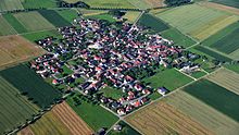
Forheim
| coat of arms | Germany map | |
|---|---|---|

|
Coordinates: 48 ° 46 ' N , 10 ° 27' E |
|
| Basic data | ||
| State : | Bavaria | |
| Administrative region : | Swabia | |
| County : | Danube Ries | |
| Management Community : | Ries | |
| Height : | 574 m above sea level NHN | |
| Area : | 23.25 km 2 | |
| Residents: | 557 (Dec. 31, 2019) | |
| Population density : | 24 inhabitants per km 2 | |
| Postal code : | 86735 | |
| Area code : | 09089 | |
| License plate : | DON, Lower Austria | |
| Community key : | 09 7 79 146 | |
| Community structure: | 2 parts of the community | |
| Association administration address: | Beuthener Str. 6 86720 Nördlingen |
|
| Website : | ||
| Mayor : | Andreas Bruckmeier ( community of voters ) | |
| Location of the municipality of Forheim in the Donau-Ries district | ||
Forheim (Swabian Fora ) is a municipality in the Swabian district of Donau-Ries .
geography
The municipality is located in the Augsburg planning region .
There are two officially named parts of the municipality (the type of settlement is given in brackets ):
- Aufhausen ( parish village )
- Forheim (parish village)
The two places also form the two demarcations that exist in the municipality.
history
timeline
1000 BC Chr .: The people of the Urnfield period built a rampart.
800 BC Chr .: The people of the Hallstatt period buried a prince in a burial mound on Weilerhungerberg.
400 BC Chr .: Celts settled near Forheim.
200: The Romans founded several manors in the hamlet and a building called "Einsiedel", the purpose of which is still unknown today.
1144: Forheim was first mentioned in a deed of donation.
1153: A document connects the name "Forheim" with the diocese of Augsburg.
13th century: The Forren family, based in Fronhofen, died out. The entire ownership changes to the Counts of Oettingen , to the monastery of Neresheim , to the Spät von Vaimingen, to the lords of Hürnheim and to those of Scheppach.
1295: Heinrich Spät von Vaimingen donated a courtyard and two fiefs to Voren to the monastery.
1305: Bishop Andreas von Würzburg donated a property of nine acres to the monastery Zimmer.
1363: Count Ludwig the Elder of Oettingen left about 15 Mlt. Grain of every kind the church set to Vore the monastery rooms. From now on the abbess of the monastery appointed the pastors.
1364: The church is incorporated into the monastery rooms by the Bishop of Augsburg
1540: The first Protestant pastor was called; his name: Michael Pferdeinger (Pfersinger).
1546: A conflagration destroys the whole village with the church and rectory except for a few houses.
1557: Final conversion to Protestantism
1628: Due to the Thirty Years War , billeting took place all the time; several looting - most of the inhabitants fled to Nördlingen. There is no record of the last ten years of the Thirty Years' War.
1638: There were only three households left (an old man on the Jungbauerhof and an old woman nearby).
1796: The imperial troops under General Montescuculi camped in the hamlet. There was a clash with French troops under General Moreau. A thunderstorm avoided a battle as it was not yet possible to shoot when it was raining. The imperial withdrew and devastated Forheim. The French then looted Forheim.
1806: Forheim was incorporated into the Bavarian Kingdom .
1819: 18 houses burned down.
1847: Johannes Link was born, who in 1875 founded the world-famous drum factory “Erste Trommelfabrik Weissenfels a. S. ", from 1907 under the name" Sonor ".
1911: The construction of a water pipe was planned.
1923: The households were connected to the power grid of the Ellwangen overland plant. 1956: At Christmas there was running water in every company for the first time. In 1966 the land consolidation was completed.
1959: The local sewer system and the first biological sewage treatment plant in the Nördlingen district were built.
1975: The kindergarten was inaugurated.
Incorporations
On January 1, 1978, the previously independent community of Aufhausen was incorporated.
Population development
Between 1988 and 2018, the population fell from 582 to 564 by 18 inhabitants or 3.1%.
- 1961: 595 inhabitants
- 1970: 624 inhabitants
- 1987: 588 inhabitants
- 1991: 600 inhabitants
- 1995: 609 inhabitants
- 2000: 607 inhabitants
- 2005: 601 inhabitants
- 2010: 574 inhabitants
- 2015: 565 inhabitants
politics
The community is a member of the Ries administrative community based in Nördlingen .
mayor
In the election on March 15, 2020, Andreas Bruckmeier (Aufhausen voter association) was elected mayor; he took office on May 1, 2020. His predecessor was Werner Thum (voter community) from May 1990 to April 2020.
Municipal council
The municipal council consists of eight members from May 1, 2020 to April 30, 2020:
- Forheim voter community 4 seats
- Voting community Aufhausen 4 seats
coat of arms
| Blazon : “Divided; at the top split by silver and black, on top of it a shortened heraldic lily in mixed up colors; below in red a golden rafter. " | |
Attractions
- St. Margaretha in Forheim
- Rectory, a half-timbered house from 1557
- St. Martin in Aufhausen
Economy and Infrastructure
Economy including agriculture and forestry
In 1998, according to official statistics in the manufacturing industry 21 and in the trade and transport sector, there were no employees at work subject to social security contributions. There were a total of 216 employees at the place of residence subject to social insurance contributions. There were six in manufacturing and two in construction. In addition, in 1999 there were 52 farms with an agricultural area of 1162 ha, of which 870 ha were arable land and 291 ha were permanent green space.
education
In 1999 the following institutions existed:
- Kindergarten: 25 kindergarten places with 23 children
Sons and daughters of the church
- Otto Erhard (1829–1888), lawyer and member of the Reichstag
- Johann Friedrich Albrecht Muck (1763–1839), ev.-luth. Pastor, composer and writer
- Wilhelm Vocke (1886–1973), born in the Aufhausen district, German banking specialist
- Johann Jakob Friedrich Vogelgesang (* 1748), Protestant pastor and song writer
- Johannes Link (1847–1914), wood turner, founder of the Sonor company
Web links
- Forheim municipality
- Forheim: Official statistics of the LfStat
- Forheim in the location database of the Bayerische Landesbibliothek Online . Bavarian State Library
Individual evidence
- ↑ "Data 2" sheet, Statistical Report A1200C 202041 Population of the municipalities, districts and administrative districts 1st quarter 2020 (population based on the 2011 census) ( help ).
- ↑ Municipal Council. Forheim parish, accessed on July 4, 2020 .
- ^ Forheim community in the local database of the Bavarian State Library Online . Bayerische Staatsbibliothek, accessed on September 3, 2019.
- ↑ a b c Federal Statistical Office (ed.): Historical municipality directory for the Federal Republic of Germany. Name, border and key number changes in municipalities, counties and administrative districts from May 27, 1970 to December 31, 1982 . W. Kohlhammer, Stuttgart / Mainz 1983, ISBN 3-17-003263-1 , p. 793 .
- ^ Entry on Forheim's coat of arms in the database of the House of Bavarian History


