Hohenaltheim
| coat of arms | Germany map | |
|---|---|---|

|
Coordinates: 48 ° 47 ' N , 10 ° 32' E |
|
| Basic data | ||
| State : | Bavaria | |
| Administrative region : | Swabia | |
| County : | Danube Ries | |
| Management Community : | Ries | |
| Height : | 454 m above sea level NHN | |
| Area : | 17.79 km 2 | |
| Residents: | 589 (Dec. 31, 2019) | |
| Population density : | 33 inhabitants per km 2 | |
| Postcodes : | 86745, 86739 | |
| Area code : | 09088 | |
| License plate : | DON, Lower Austria | |
| Community key : | 09 7 79 162 | |
| Community structure: | 8 parts of the community | |
| Association administration address: | Beuthener Str. 6 86720 Nördlingen |
|
| Website : | ||
| Mayoress : | Martina Göttler (Citizens' Block / Independent) | |
| Location of the community of Hohenaltheim in the Donau-Ries district | ||
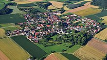
Hohenaltheim is a municipality in the Swabian district of Donau-Ries . The place of the same name is both the capital and the seat of the municipal administration.
geography
Hohenaltheim is located on the southern edge of the Nördlinger Ries and in the Ries Geopark . The Froschbach, a source river of the Wörnitz , flows through the place.
There are eight officially named municipal parts (the type of settlement is given in brackets ):
|
|
There are the districts of Hohenaltheim and Niederaltheim.
Neighboring communities are in the north the city of Nördlingen and the community Möttingen , in the east Mönchsdeggingen , in the south Bissingen and Amerdingen and in the west Forheim and Ederheim . With the exception of the municipality of Bissingen, which is part of the district of Dillingen an der Donau , all municipalities are part of the district of Donau-Ries .
history
Until the parish merger
Hohenaltheim was mentioned in a document as early as 878. The Synod of Hohenaltheim took place here in 916 . Until around 1300 the place was called Altheim. In 1508 Hans von Altheim sold his property to the Counts of Oettingen . In 1633 Hohenaltheim was plundered three times, in 1634 the battle of the Albuch took place just a few kilometers away; it brought the Catholic League victory over the Evangelical Union.
From the middle of the 18th century, Hohenaltheim Castle served as a summer residence , initially on the line from Oettingen-Oettingen and later that of Oettingen-Wallerstein. With the Rhine Confederation Act in 1806, the place then became part of the Kingdom of Bavaria . The center of Niederaltheim, which was almost completely destroyed and rebuilt after a major fire in 1899, is under ensemble protection.
With the community edict of 1818 , the community of Hohenaltheim was created with the community parts Forsthaus and Sägmühle. On July 1, 1973, the municipality of Niederaltheim and its parts of the municipality with Brunnenhaus, Frohnmühle, Ganzenmühle, Hochhaus, Karlshof, Mühlauhof, Schellenhof and Weiherhof were incorporated as part of the regional reform .
Population development
Between 1988 and 2018 the municipality grew from 552 to 583 by 31 inhabitants or by 5.6%.
- 1961: 700 inhabitants
- 1970: 641 inhabitants
- 1987: 575 inhabitants
- 1991: 587 inhabitants
- 1995: 616 inhabitants
- 2000: 626 inhabitants
- 2005: 626 inhabitants
- 2010: 591 inhabitants
- 2015: 569 inhabitants
politics
mayor
First mayor is Martina Göttler (Bürgerblock / UW). She took office on May 1, 2020. Your predecessor as mayor from May 2008 to April 2020 was the veterinarian and local researcher Wulf-Dietrich Kavasch .
Municipal council
The municipal council consists of eight members who will be divided between the following electoral communities for the 2014-2020 term of office:
- Citizens' bloc / Free voter community 5 seats
- Independent voters Hohenaltheim-Niederaltheim 3 seats
For the 2020–2026 term of office, the Citizens' Bloc and Independent Voters made a joint list that received all eight seats.
The municipal tax revenue in 1999 amounted to the equivalent of € 989,000, of which € 131,000 was trade tax revenue (net).
coat of arms
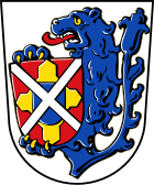
| Blazon : “In silver, the body of a gold-armored and red-tongued blue lion holding a red shield in its paws; in it a blue heart shield, from which four golden iron hats extend to the edges of the shield, on the whole covered with a silver tray. " | |
Attractions
- Burg Hochhaus der Herrschaft Hochhaus
- Jagdschloss (seat of the House of Oettingen-Wallerstein )
- Evangelical St. John's Church
- Pfister's farmhouse museum
- Thing place
Architectural monuments
Economy and Infrastructure
Economy including agriculture and forestry
Even if agriculture no longer plays a particularly important role in Hohen- and Niederaltheim, the two villages can still be described as agricultural. The forests of the Riesrand are predominantly owned by the Princely House of Oettingen-Wallerstein. There are various businesses in the community, including a construction business, a gardening shop, a bakery and a sanitary facility. The Unterringingen transmitter is visible from afar .
education
In 2011 there were the following institutions:
- Day care center for children: 30 kindergarten places with 20 children (five of them under three years of age)
Until 2004 there was a school with four primary classes.
Sons and daughters of the church
- Johann Maximilian Albrecht von Laßberg (1711–1788), Saxe-Weimar officer
- Karl Schott von Schottenstein (1792–1882), government director in Ulm and member of the state parliament
literature
- Wilfried Sponsel: The history of Hohenaltheim and Niederaltheim. Hohenaltheim 2010, ISBN 978-3-939777-67-0 .
Web links
Individual evidence
- ↑ "Data 2" sheet, Statistical Report A1200C 202041 Population of the municipalities, districts and administrative districts 1st quarter 2020 (population based on the 2011 census) ( help ).
- ^ Community Hohenaltheim in the local database of the Bavarian State Library Online . Bayerische Staatsbibliothek, accessed on September 2, 2019.
- ^ The history of the church in Hohenaltheim. Archived from the original on May 25, 2005 ; Retrieved February 26, 2009 .
- ↑ a b c Federal Statistical Office (ed.): Historical municipality directory for the Federal Republic of Germany. Name, border and key number changes in municipalities, counties and administrative districts from May 27, 1970 to December 31, 1982 . W. Kohlhammer, Stuttgart / Mainz 1983, ISBN 3-17-003263-1 , p. 792 .
- ↑ Mayor of Hohenaltheim: The results of the runoff and local elections in 2020. Augsburger Allgemeine, accessed on August 20, 2020 .
- ^ Entry on the coat of arms of Hohenaltheim in the database of the House of Bavarian History


