Amerdingen
| coat of arms | Germany map | |
|---|---|---|

|
Coordinates: 48 ° 44 ' N , 10 ° 29' E |
|
| Basic data | ||
| State : | Bavaria | |
| Administrative region : | Swabia | |
| County : | Danube Ries | |
| Management Community : | Ries | |
| Height : | 530 m above sea level NHN | |
| Area : | 19.11 km 2 | |
| Residents: | 849 (Dec. 31, 2019) | |
| Population density : | 44 inhabitants per km 2 | |
| Postal code : | 86735 | |
| Area code : | 09089 | |
| License plate : | DON, Lower Austria | |
| Community key : | 09 7 79 112 | |
| LOCODE : | DE 6AO | |
| Community structure: | 4 parts of the community | |
| Association administration address: | Beuthener Str. 6 86720 Nördlingen |
|
| Website : | ||
| First Mayor : | Xaver Berchtenbreiter ( FWG ) | |
| Location of the community of Amerdingen in the Donau-Ries district | ||
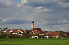
Amerdingen is a municipality in the Swabian district of Donau-Ries and a member of the Ries administrative community based in Nördlingen .
geography
Amerdingen is part of the Augsburg planning region and is located on the Kessel river . In the south it borders on the district of Dillingen .
There are four officially named parts of the municipality (the type of settlement is given in brackets ):
- Amerdingen ( parish village )
- Bollstadt (parish village)
- Seelbronn ( wasteland )
- Sternbach (wasteland)
The municipality is divided into the two districts Amerdingen and Bollstadt.
Geologically, the area belongs to the Riesalb , the easternmost, only hilly foothills of the Swabian Alb.
history
Until the church is planted
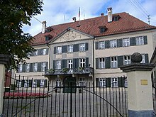
Before 1806, Amerdingen was the seat of the lordship of the same name and belonged to the Barons Schenk von Stauffenberg . The Stauffenbergers, who were raised to the rank of count by Ludwig II of Bavaria in the 19th century, are still the largest landowners in Amerdingen and at the same time residents of the castle in town. All living bars in Stauffenberg come from the so-called "Amerdinger line". They are descendants of the donor Hans von Stauffenberg, who in 1566 acquired the Amerdingen manor by marrying Barbara von Westernach .
Amerdingen was between the Duchy of Palatinate-Neuburg and the County of Oettingen , which held sovereign rights over Amerdingen. With the entry into force of the Rhine Confederation Act in 1806, the place fell to the Kingdom of Bavaria .
Stauffenberg family
One of the descendants of the first Amerdinger Stauffenberg, Hans von Stauffenberg, is Claus Schenk Graf von Stauffenberg , who dared the unsuccessful assassination attempt on Adolf Hitler on July 20, 1944 and paid with his life.
Incorporations
On May 1, 1978, the previously independent municipality of Bollstadt was incorporated.
Population development
Between 1988 and 2018 the municipality grew from 795 to 841 by 46 inhabitants or 5.8%.
- 1961: 840 inhabitants
- 1970: 824 inhabitants
- 1987: 789 inhabitants
- 1991: 871 inhabitants
- 1995: 873 inhabitants
- 2000: 852 inhabitants
- 2005: 872 inhabitants
- 2010: 845 inhabitants
- 2015: 851 inhabitants
politics
Hermann Schmidt (village community) has been mayor since May 1996; Xaver Berchtenbreiter (FWG) has been elected as his successor from May 1, 2020. The DG Amerdingen has five seats and the FWG three seats in the municipal council from 2020 to 2026 .
Sons and daughters of the church
- Alfred Schenk Graf von Stauffenberg (1860–1936) High Court Marshal of King Wilhelm II of Württemberg
Culture and sights
Buildings
- Catholic parish church of St. Vitus
- Amerdingen Castle of the Counts of Stauffenberg from the 18th century
Architectural monuments
Natural monument four-handle oak
⊙ , also referred to as a "four-handle Lige oak"English oakof the town is about 1.5 km south on a farm road in the open field. Thetreeveteran, which isprotectedas anatural monument(ND-06554) and entered in thelist of distinctive and old tree specimens,is a tree that has grown together from four trunks, therefore "Viergrifflig". Three of the stems are grown together up to a height of about two meters. A fourth trunk, which is still attached to the base trunk on the ground, separates completely from the other three after just 1 m.
The age of the striking oak is estimated to be around 250 years. When measured in 2019, the tree reached a height of 21 m with a crown diameter of 20 m. The measurements for the trunk circumference are controversial and differ significantly from one another; they range from 6.87 m (chest height circumference) for "monumental oaks", over 7.75 m (base circumference) as a value of the Lower Nature Conservation Authority, up to 8.09 m (measuring height 1 m) in the natural monument list .
Economy and Infrastructure
Economy including agriculture and forestry
In 2017 there were 126 jobs subject to social security contributions in the municipality. Of the resident population, 382 people were in an employment relationship subject to compulsory insurance. This meant that the number of out-commuters was 256 more than that of in-commuters. 10 residents were unemployed. In 2016 there were 11 farms.
education
In 2018 there were the following institutions:
- 1 day-care center with 55 places and 53 supervised children, seven of them under three years of age
- Primary school with five teachers, four classes and 64 students
Web links
- Homepage
- Entry on the coat of arms of Amerdingen in the database of the House of Bavarian History
- Amerdingen: Official statistics of the LfStat
- Amerdingen in the location database of the Bayerische Landesbibliothek Online . Bavarian State Library
Individual evidence
- ↑ "Data 2" sheet, Statistical Report A1200C 202041 Population of the municipalities, districts and administrative districts 1st quarter 2020 (population based on the 2011 census) ( help ).
- ^ Amerdingen community: Administration. Retrieved May 24, 2020 .
- ^ Community Amerdingen in the local database of the Bayerische Landesbibliothek Online . Bayerische Staatsbibliothek, accessed on September 3, 2019.
- ↑ a b c Federal Statistical Office (ed.): Historical municipality directory for the Federal Republic of Germany. Name, border and key number changes in municipalities, counties and administrative districts from May 27, 1970 to December 31, 1982 . W. Kohlhammer, Stuttgart / Mainz 1983, ISBN 3-17-003263-1 , p. 794 .
- ↑ “Four-handle oak near Amerdingen” in “Monumentale Eichen” by Rainer Lippert, at www.monumentale-eichen.de


