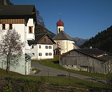
Hinterhornbach
|
Hinterhornbach
|
||
|---|---|---|
| coat of arms | Austria map | |
|
|
||
| Basic data | ||
| Country: | Austria | |
| State : | Tyrol | |
| Political District : | Reutte | |
| License plate : | RE | |
| Surface: | 50.55 km² | |
| Coordinates : | 47 ° 21 ' N , 10 ° 27' E | |
| Height : | 1101 m above sea level A. | |
| Residents : | 91 (January 1, 2020) | |
| Population density : | 1.8 inhabitants per km² | |
| Postal code : | 6646 | |
| Area code : | 05632 | |
| Community code : | 7 08 15 | |
| NUTS region | AT331 | |
| Address of the municipal administration: |
Hinterhornbach 18 6646 Hinterhornbach |
|
| politics | ||
| Mayor : | Martin Kärle (Together for Hinterhornbach) | |
|
Municipal Council : (2016) (9 members) |
||
| Location of Hinterhornbach in the Reutte district | ||
 Hinterhornbach in the Hornbachtal |
||
| Source: Municipal data from Statistics Austria | ||
Hinterhornbach is a municipality in the Reutte district in Tyrol ( Austria ) with 91 inhabitants (as of January 1, 2020).
geography
Hinterhornbach is around 1100 m above sea level. A. in the rear part of the Hornbach valley , a side valley of the Lech valley , at the foot of the 2592 m high Hochvogel in the Allgäu Alps .
Community structure
The small community includes only one cadastral community and locality .
In addition to the village of Hinterhornbach itself, the Rotten Krummenstein and Pretterhof belong to the community. The self-catering house Kaufbeurer Haus also belongs to the community. The community is located in the judicial district of Reutte .
Neighboring communities
| Bad Hindelang ( Lkr. Oberallgäu. , BY , DE ) |
|
|
| Oberstdorf ( Lkr. Oberallgäu. , BY , DE ) |

|
Elmen |
| Holzgau | Elbigenalp | Häselgehr |
history
The place was first mentioned in a document in 1235. The settlement took place as an alpine area from the Allgäu over the yokes . The original individual farms were transformed into farm groups and hamlet-like settlements.
Hinterhornbach was from time immemorial the parish Elbigenalp , from 1515 Elmen (1758 Kuratie , 1761/64 Widum ) and the jurisdiction of Ehrenberg subordinated, and belonged to the lawyers of Unterlechtal of the Lechtal region . 1810-1833 (1805-1816 in the Innkreis of the Kingdom of Bavaria , then again Austrian) the village was united with Hinterhornbach to form the tax district (Austrian: tax communities ) Hornbach . In 1883 Hinterhornbach developed its own community.
Migration in the 1950s and 1960s could be stopped by infrastructure measures such as road expansion in the valley.
coat of arms
Blazon :
- A silver ram's head in blue over two narrow, oblique wavy bars .
The municipal coat of arms, awarded in 1979, symbolizes the place name as a talking coat of arms and also reminds of the earlier important sheep breeding.
Population development

politics
The municipal council has a total of nine members.
- With the municipal council and mayor elections in Tyrol in 2010 , the municipal council had the following distribution: 5 ÖVP common for Hinterhornbach, and 4 ÖVP community list Hinterhornbach.
- With the municipal council and mayoral elections in Tyrol in 2016 , the municipal council has the following distribution: 9 ÖVP together for Hinterhornbach.
- mayor
- until 2010 Wilfried Lechleitner (ÖVP)
- since 2010 Martin Kärle (ÖVP together for Hinterhornbach)
Culture and sights
- Catholic parish church Hinterhornbach Our Lady of Good Advice
Personalities
- Johann Kärle (1835–1913), painter
literature
- Hinterhornbach hiking guide. Natural and cultural hiking guide by Gustav and Georg Dinger , ed. vd Section Donauwörth d. German Alpine Club, Verlag Ludwig Auer, ISBN 978-3-9807169-6-3
- Sebastian Hölzl: The municipal archives of the Reutte district: T. Without market Reutte and city of Vils . Volume 1, Office of the Tyrolean State Government, Tyrolean State Archives, Innsbruck 1997, ISBN 978-3-901464-06-5 (= Volume 37 of Edition Atelier: Tiroler Geschichtsquellen ), 15 / Hinterhornbach , p. 232 ff.
Web links
- Contact details for the municipality at tirol.gv.at
- Entry on Hinterhornbach in the Austria Forum (in the AEIOU Austria Lexicon )
- Hinterhornbach , in the history database ofthe association "fontes historiae - sources of history"
- History of Hinterhornbach by the DAV Donauwörth
Individual evidence
- ↑ Peter Anreiter, Christian Chapman, Gerhard Rampl: The community names of Tyrol: origin and meaning. Volume 17 of publications of the Tiroler Landesarchiv , Universitätsverlag Wagner, Innsbruck 2009, ISBN 978-3-7030-0449-0 , section Hornbach (front, back) , p. 508 ff.
- ↑ Provincial Law Gazette for Tyrol No. 26/1979 ( digitized version )
- ↑ Tyrol Atlas: Coat of Arms of Tyrol - Hinterhornbach ( Memento from July 1, 2007 in the Internet Archive )


