
Weißenbach am Lech
|
Weißenbach am Lech
|
||
|---|---|---|
| coat of arms | Austria map | |
 |
|
|
| Basic data | ||
| Country: | Austria | |
| State : | Tyrol | |
| Political District : | Reutte | |
| License plate : | RE | |
| Surface: | 82.01 km² | |
| Coordinates : | 47 ° 27 ' N , 10 ° 39' E | |
| Height : | 885 m above sea level A. | |
| Residents : | 1,252 (January 1, 2020) | |
| Population density : | 15 inhabitants per km² | |
| Postal code : | 6671 | |
| Area code : | 05678 | |
| Community code : | 7 08 36 | |
| NUTS region | AT331 | |
| Address of the municipal administration: |
Kirchplatz 3 6671 Weißenbach am Lech |
|
| Website: | ||
| politics | ||
| Mayor : | Hans Dreier (Free Association of Voters) | |
|
Municipal Council : (2016) (13 members) |
||
| Location of Weißenbach am Lech in the Reutte district | ||
  |
||
 Weißenbach from the Leilachspitze |
||
| Source: Municipal data from Statistics Austria | ||

Weißenbach am Lech is a municipality in the Reutte district in Tyrol ( Austria ) with 1252 inhabitants (as of January 1, 2020).
geography
The elongated village of Weißenbach is located at the confluence of the Tannheim Valley and the Lech Valley, at the foot of the Gaicht Pass . There the Weißenbach (from the Tannheimer Tal) and the Rotlech flow into the Lech .
Neighboring communities
|
Nesselwängle Tannheim |
Ehenbichl Höfen Reutte Wängle |
|
.svg)
|
||
|
Forchach Hinterhornbach Stanzach Vorderhornbach |
Community structure
The municipality includes the following two localities (residents as of January 1, 2020):
- Gaicht (27)
- Weißenbach am Lech (1225)
history
A Roman grave find in Weißenbacher Oberhof testifies to the early importance of the place. Weißenbach was first mentioned in documents in 1200. In the Middle Ages, the salt road led from Hall in Tirol over the Gaichtpass into the Tannheimer Tal and on to the Lake Constance area . The Gaicht district is located at the entrance to the Tannheim Valley.
Economy and Infrastructure
The proximity to the district capital Reutte , which is ten kilometers away, resulted in stronger settlement growth, and some industrial and commercial areas have also settled in the village. A special feature is the only minable gypsum deposit in Tyrol on the Gaichtpass, which is still being processed on site by the company Gipswerk Schretter & Cie GesmbH, based in Vils, into stucco and building plaster .
traffic
A bypass road relieves Weißenbach from traffic through the Lech Valley.
Culture and sights
Personalities
- Emil Kerle (1877–1961), painter
gallery
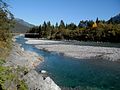
The Lech near Weißenbach

Weißenbach from the Gaichtpass
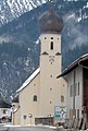
The parish church of St. Sebastian


Web links
Individual evidence
- ↑ Statistics Austria: Population on January 1st, 2020 by locality (area status on January 1st, 2020) , ( CSV )
Bach | Berwang | Biberwier | Bichlbach | Breitenwang | Ehenbichl | Ehrwald | Elbigenalp | Elmen | Forchach | Grän | Gramais | Häselgehr | Heiterwang | Hinterhornbach | Courtyards | Holzgau | Young wood | Emperor | Lechaschau | Lermoos | Musau | Nameless | Nesselwängle | Pfafflar | Pflach | Pinswang | Reutte | Schattwald | Stanzach | Steeg | Tannheim | Vils | Vorderhornbach | Wängle | Weißenbach am Lech | Zöblen