
Nesselwängle
|
Nesselwängle
|
||
|---|---|---|
| coat of arms | Austria map | |
 |
|
|
| Basic data | ||
| Country: | Austria | |
| State : | Tyrol | |
| Political District : | Reutte | |
| License plate : | RE | |
| Surface: | 23 km² | |
| Coordinates : | 47 ° 29 ' N , 10 ° 37' E | |
| Height : | 1136 m above sea level A. | |
| Residents : | 462 (January 1, 2020) | |
| Postal code : | 6672 | |
| Area code : | 05675 | |
| Community code : | 7 08 24 | |
| NUTS region | AT331 | |
| Address of the municipal administration: |
Nesselwängle 74 6672 Nesselwängle |
|
| Website: | ||
| politics | ||
| Mayor : | Klaus Hornstein (Economic Progress) | |
|
Municipal Council : (2016) (11 members) |
||
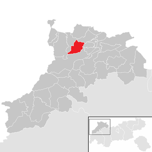
| Location of Nesselwängle in the Reutte district | ||
  |
||
 View of Nesselwängle and the Tannheim Valley |
||
| Source: Municipal data from Statistics Austria | ||

Nesselwängle is a municipality with 462 inhabitants (as of January 1, 2020) in the Tannheimer Tal in the Reutte district in Tyrol ( Austria ). The community is located in the judicial district of Reutte . The street village of Nesselwängle is located at the eastern entrance of the Tannheimer Valley and is the third largest municipality in the valley in terms of area. The districts of Rauth on a steep hillside, Schmitte an der Straße and Haller am Haldensee also belong to Nesselwängle .
In the Middle Ages, salt was transported from Hall in Tirol through the Tannheim Valley to the Lake Constance area . Today Nesselwängle is a place for commuters and a popular tourist community for summer and winter holidays (sport, leisure, wellness, ski area, cross-country ski run).
location
traffic
Nesselwängle is toll-free via the Tannheimer Straße B 199 from the Engetal, the Gaichtpass or the Oberjochpass to the transport network.
Neighboring communities
| Grän | Musau | |
| Tannheim |
.svg)
|
Wangle |
| Weißenbach am Lech |
Community structure
The municipality includes the following three localities (residents as of January 1, 2020):
- Haller (36)
- Nesselwängle (389)
- Rauth (37)
history
The place was first mentioned in 1434 as Nesselwänglin . The Tyrolean cartographer Peter Anich referred to the place in the 18th century as Klein Nesselwang to distinguish it from Groß Nesselwang an der Wertach.
Ecclesiastically Nesselwängle belonged to the parish Tannheim. In 1891 the place became its own parish.
Culture and sights
mountains
Schartschrofen , Gimpel , Rote Flüh , Kellenspitze , Schneid , Gehrenspitze , Gaichtspitze , Hahnenkamm , Krinnenspitze , Litnisschrofen , Leilachspitze
Lakes
Haldensee (located in the Haller district)
Huts and alpine pastures
Gessenwangalm, Gimpelhaus , Gimpelalpe, Haldenseehaus , Tannheimer Hütte , Krinnenalpe, Nesselwängler Edenalm, Gräner Ödenalpe,
Events
- Balloon festival
- Sled dog racing
- Three hut races
- "Fun tour run" to the Krinnenalpe
- Village evenings with the Nesselwängle band and the Alpenklang men's choir
- Air rifle shooting for guests
Picture gallery

Köllenspitze from the cutting

Haldensee

View from the Roten Flüh to the Gimpelhaus

Krinnenalpe
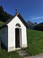
Rainbow Chapel on the way to Rauth

Rauth district with the Holy Trinity Chapel

Haller district with Johanneskapelle

Parish Church of the Assumption


economy
Nesselwängle is mainly characterized by the Tannheimer Taler ski and hiking tourism. There are a lot of holiday apartments, hotels and pensions in town. The Krinnenalpe skiing and hiking area can be easily reached from the village on foot or by car. There is also a ski school, a supermarket and a sports shop as well as the Nesselwängle lift company . In 2012 the high ropes course "Tannheimer Tal climbing forest" opened at the foot of the Krinnenspitze.
Personalities
- Lorenz Zotz the Elder (1862–1903), plasterer
- Hubert Zotz (1875–1960), stucco artist
- Lorenz Zotz the Younger (1902–1985), stucco artist
- Aemilian Hubert 'Emilian' Zotz (1907 – unknown), plasterer and marbleist
- Ämilian Zotz (1908–1984), stucco artist
- Ulrike Haunschmid (* 1945), politician ( FPÖ ) and innkeeper
Web links
Individual evidence
- ↑ a b c Rauth, Haller am Haldensee, Tannheimer Tal, Adlerhorst, Gimpelhaus, Krinnenhütte, Edenalm, Schneetalalm, Tannheimer Hütte, Rote Flüh, Gimpel, Köllenspitze, Krinnenspitze, Drei Hütten race. Retrieved June 19, 2018 .
- ↑ Statistics Austria: Population on January 1st, 2020 by locality (area status on January 1st, 2020) , ( CSV )
- ↑ Manfred Hailer in the village newspaper August 2013 ( Memento of the original from January 2, 2016 in the Internet Archive ) Info: The archive link was automatically inserted and not yet checked. Please check the original and archive link according to the instructions and then remove this notice.
Bach | Berwang | Biberwier | Bichlbach | Breitenwang | Ehenbichl | Ehrwald | Elbigenalp | Elmen | Forchach | Grän | Gramais | Häselgehr | Heiterwang | Hinterhornbach | Courtyards | Holzgau | Young wood | Emperor | Lechaschau | Lermoos | Musau | Nameless | Nesselwängle | Pfafflar | Pflach | Pinswang | Reutte | Schattwald | Stanzach | Steeg | Tannheim | Vils | Vorderhornbach | Wängle | Weißenbach am Lech | Zöblen