
Schneid (Tannheim Mountains)
| Cutting | ||
|---|---|---|
 |
||
| height | 2009 m above sea level A. | |
| location | Tyrol , Austria | |
| Mountains | Tannheimer Berge , Allgäu Alps | |
| Dominance | 0.7 km → Kelleschrofen | |
| Notch height | 130 m ↓ Sabachjoch | |
| Coordinates | 47 ° 29 '35 " N , 10 ° 38' 41" E | |
|
||
| rock | Wetterstein lime | |

The cutting (also cutting point , cutting edge ) is a 2009 m above sea level. A. high mountain in the Austrian part of the Allgäu Alps .
Location and surroundings
The mountain , located in the Tannheimer Berge subgroup , forms the northern end point of a short ridge that runs north from the Gaichtspitze ( 1986 m ) over the Hahnenkamm ( 1938 m ) and is perpendicular to the main ridge of the Tannheimer Berge. To the south, the Hochjoch ( 1754 m ) separates the Schneid from the Ditzl ( 1817 m ), in the northwest lies the Sabachjoch ( 1860 m ), which goes over to the Kelleschrofen ( 2091 m ) on the Kellespitze ( 2238 m ). The Schneid is connected to the Gehrenspitze ( 2163 m ) via the Gehrenjoch ( 1858 m ) . The flanks of the Schneid drop to the southwest into the Tannheimer Tal , to the north into the short Sabach valley and to the southeast into the Lech valley .
The district on which most of the Schneid is located is Wängle , the border to the municipality of Musau in the north runs over the summit .
geology
In the area of the cutting tip one can observe a thrust of the Allgäu layers through the Lech valley cover . This begins at the Hochjoch. Ascending northwards, a fold made of Wetterstein limestone , Raibler layers and main dolomite can be observed. Given by the fold, the main dolomite is followed by Raibler layers and Wetterstein limestone. This is followed by two layers of Partnach layers , which are interrupted by shell limestone . The top-forming Wetterstein limestone, which continues north to the main peaks, is deposited on top.
Origin of name
The Schneid was first mentioned in 1880 on a map of Austria as Schneid Sp. The name is derived from the grass ridge that extends to the west . Such a "cutting" is used in Bavarian for sharp burrs. Thaddäus Steiner therefore assumes that the use with the Schneid has its westernmost branch, since Egg was otherwise used in the Allgäu . In the Tannheimer Tal, on the other hand, it was named because of the shape of a church.
Ascent
The base for climbing the Schneid is the mountain station of the Reutten Hahnenkammbahn , from where the path leads over the Tiefjoch and the Ditzl to the southwest flank of the Schneid and into the Sabachjoch. The north-west ridge to the summit, which begins here and has a climbing system, requires surefootedness , with variants directly at the edge of the ridge, places up to level II are possible. The Sabachjoch can also be reached from the Sabachtal and the Tannheimer Tal, and the ascent from the Gimpelhaus ( 1659 m ) and the Tannheimer Hütte ( 1730 m ) is also possible. The ascent of the Schneid over the Gehrenjoch, north flank and east ridge is not difficult. Access to the Gehrenjoch is from the Sabach valley, the Lech valley or from the mountain station.
On the southern flank there is a short, approximately 50 meter long climb (IV +), which Koch first climbed in 1980.
In winter, the Schneid can be climbed as a ski tour through the Raintal and Sabach Valley.
photos
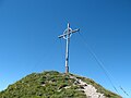
Summit cross
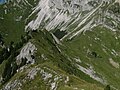
Northwest ridge

Southwest flank

South flank


Web links
Individual evidence
- ↑ a b c Dieter Seibert: Alpine Club Guide alpine - Allgäu Alps and Ammergau Alps . 17th edition. Bergverlag Rother, Munich 2008, ISBN 978-3-7633-1126-2 (p. 245 f.).
- ↑ a b Thaddäus Steiner : Allgäu mountain names . 2nd Edition. Kunstverlag Josef Fink, Lindenberg 2008, ISBN 978-3-8987-0389-5 (p. 185).
- ^ Federal Office for Metrology and Surveying Austria: Austrian Map online (Austrian map 1: 50,000) . Retrieved April 23, 2012.
- ^ Dieter Richter: Allgäu Alps . In: Manfred Gwinner (Ed.): Geological Guide Collection Volume 77 . 3rd revised edition. Brothers Borntraeger, Stuttgart 1984. (p. 219 f.).
- ^ A b Marcus Lutz: Alpine Club Guide - Tannheimer Berge . 2nd Edition. Bergverlag Rudolf Rother , Munich 1992, ISBN 978-3-7633-1239-9 (p. 357).
- ↑ Dieter Elsner, Michael Seifert: Ski touring guide Lechtal Alps including Tannheim mountains . 6th edition. Panico Alpinverlag, Köngen 2010, ISBN 978-3-9367-4011-0 (p. 200 f.).