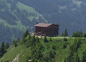
Gimpelhaus
| Gimpelhaus | ||
|---|---|---|
|
The Gimpelhaus above the Tannheim Valley |
||
| Mountain range | Allgäu Alps | |
| Geographical location: | 47 ° 29 '37 " N , 10 ° 36' 50" E | |
| Altitude | 1659 m above sea level A. | |
|
|
||
| owner | Guem family | |
| Construction type | Refuge | |
| Development | Material ropeway | |
| Usual opening times | Early May to late October | |
| accommodation | 50 beds, 170 camps | |
| Web link | www.tannheimertal.at/gimpelhaus | |
| Hut directory | PES | |
The Gimpelhaus ( 1659 m above sea level ) is a private refuge in the Tannheimer Tal in the Austrian state of Tyrol . It is located above the village of Nesselwängle .
In a sunny altitude, the Gimpelhaus is a starting point for hiking and climbing tours, especially to the nearby Gimpel , Kellenspitze and Rote Flüh mountain groups . With 50 beds and 170 camps, it offers enough overnight accommodation. There is a climbing wall in the hut . It is open from the beginning of May to the end of October and is open during this time.
Hiking destinations
- Gehrenspitze , 2164 m , walking time: 2 hours 50 minutes
- Gimpel , 2176 m , walking time: 3 hours
- Kellenspitze , 2239 m , walking time: 1 hour 50 minutes
- Rote Flüh , 2111 m , walking time: 1 hour 20 minutes
Neighboring huts and crossings
- Otto Mayr Hut approx. 3 hours
- Bad Kissinger Hütte approx. 5 hours
- Tannheimer hut approx. 10 min.
- Willi Merkl Memorial Hut
cards
- Alpine Club Card BY 5 Tannheimer Berge - Köllenspitze, Gaishorn (1: 25,000)
Web links
Commons : Gimpelhaus - Collection of pictures, videos and audio files

