Gaichtspitze
| Gaichtspitze | ||
|---|---|---|
|
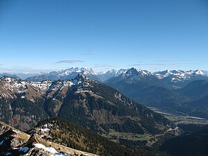
Gaichtspitze in front of Zugspitze and Thaneller from Krinnenspitze |
||
| height | 1986 m above sea level A. | |
| location | Tyrol , Austria | |
| Mountains | Allgäu Alps , sub-group Tannheimer Berge | |
| Dominance | 3 km → Schneid | |
| Notch height | 269 m ↓ Tiefjoch | |
| Coordinates | 47 ° 27 '57 " N , 10 ° 38' 22" E | |
|
|
||
The Gaichtspitze is a 1986 meter high mountain in the Austrian state of Tyrol and is the southernmost of the Tannheim mountains . It consists of Wetterstein limestone and has striking rocky areas on its northern side. Its southern flank is covered with forest and mountain pines . For tourism, it is made accessible by hiking trails, a cable car and ski lifts .
Location and surroundings
The mountain forms the southern tip of the Tannheimer Berge and falls to the southeast into the Lechtal , in the southeast to the Gaichtpass (1082 m) and to the west into the Weißenbachtal . A neighboring mountain in the northeast is the Hornbergle with an altitude of 1755 meters. The closest place is in the west Gaicht , a district of the community Weißenbach am Lech . Höfen is about five kilometers as the crow flies in a north-easterly direction.
Tourist development
The Gaichtspitze is easily accessible by several hiking trails from both the Weißenbach and Lech valleys, and a cable car leads from Höfen up to the Höfener Alm at 1735 meters above sea level. The last section of the way to the summit leads through a steep rock channel and is provided with a rope.
Literature and map
- Dieter Seibert: Ausserfern, Rother hiking guide . Munich, Bergverlag Rother , 2007. ISBN 978-3-7633-4055-2
- Dieter Seibert: Tannheimer Tal, Rother hiking guide . 7th edition 2009, Bergverlag Rother, Munich, ISBN 978-3-7633-4229-7
- Austrian map 1: 50,000, sheet 115, Reutte
Web links
Individual evidence
- ↑ Dieter Seibert: Alpine Club Guide Allgäuer Alpen , Bergverlag Rother, Munich 2008, p. 248, ISBN 978-3-7633-1126-2


