
Crutch tip
| Crutch tip | ||
|---|---|---|
 Krinnenspitze from the northeast at sunrise |
||
| height | 2000 m above sea level A. | |
| location | Tyrol , Austria | |
| Mountains | Vilsalpseeberge , Allgäu Alps | |
| Dominance | 1.7 km → Litnisschrofen | |
| Notch height | 260 m ↓ notch to litnis crate | |
| Coordinates | 47 ° 28 '26 " N , 10 ° 35' 7" E | |
|
||
| rock | Main dolomite | |

The Krinnenspitze is a 2000 meter high mountain in the Allgäu Alps that rises in Austria . It is accessible by hiking trails and there is a small ski area operated by the Nesselwängle lift company on the north flank .
Location and surroundings
The Krinnenspitze is located in the Austrian state of Tyrol . It lies entirely in the municipality of Nesselwängle . At the northern foot of the mountain is the Haldensee (1124 m).
The summit of the Krinnenspitze towers over the Strindenbachtal in the west, the Tannheimer Tal in the north and the Weißenbachtal in the south. Opposite the Krinnenspitze in the north are the Tannheimer Berge (2238 m). To the west, the flanks of the Krinnenspitze descend towards the Litnisschrofen (2068 m). This notch and the litniscrust represent the reference points for notch height and dominance , which are 175 meters and 1.8 kilometers respectively.
The height of the gap at the top of the Krinnenspitze is at least 260 meters, its dominance 1.7 kilometers, with the Litnisschrofen being the reference mountain in each case.
geology
In the top of the summit, the top of the krinn consists of main dolomite . This is stored on Lias spotted marl .
Origin of name
The Krinnenspitze was first mentioned in 1774 by Peter Anich in the Atlas Tyrolensis as Rinnen Spitz . In the Schmitt'schen map of South West Germany from 1797 is a Krinnenspitz recorded. The name comes from the Alpe Krinnen on the north side, which is documented for the year 1769. It takes its name from the channel that runs down from the alpine pasture to the Haldensee. "Krinne" in the meaning of notch, cut or groove is an Old High German word, evidenced as krinna . This is borrowed from the Rhaeto-Romanic crēnna .
Ascent
Marked hiking trails lead to the Krinnenspitze from different sides. On the north side, the mountain station of the Krinnenalpe chairlift forms a base. This can be reached either by lift or on hiking trails 11 , 12 and 13 . It is now possible to climb the mountain via the east side on the Gamsbocksteig or the west side on the Alpenrosensteig . Both paths require surefootedness . A simpler variant is over the west side to the south flank and from there to the summit. From the place Rauth leading Enziansteig on the southern flank of the summit.
In winter, the Krinnenspitze can be climbed as part of a ski tour . Usually the climbs lead from the Strindental or from Rauth to the summit.
photos

North side of the Einstein with Haldensee
South side of the litniscable

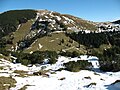
Summit from the Gamsbocksteig
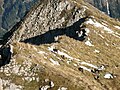
Chamois on the Gamsbocksteig


Web links
- Official website of the Nesselwängle lift company
- Krinnenspitze - route of the ski tour with pictures and GPS data
Individual evidence
- ↑ a b Compass hiking, bike and ski tour map: Sheet 04 Tannheimer Tal (1: 35,000). ISBN 978-3-85491-644-4 (as of February 2007).
- ↑ Federal Office for Metrology and Surveying Austria: Austrian Map online . Retrieved May 8, 2010.
- ↑ Exact value not known, stated value is a minimum value (can be up to 19 meters higher). It was determined from the distance between the contour lines (20 meters in altitude ) on a topographic map ( scale 1: 25,000).
- ↑ Ernst Zettler, Heinz Groth: Alpine Club Guide - Allgäu Alps . 12th, completely revised edition. Bergverlag Rudolf Rother , Munich 1985, ISBN 3-7633-1111-4 , p. 466f.
- ^ Thaddäus Steiner : Allgäu mountain names . 2nd Edition. Kunstverlag Josef Fink, Lindenberg 2008, ISBN 978-3-8987-0389-5 , p. 124.
- ↑ Dieter Seibert: Alpine Club Guide alpine - Allgäu Alps and Ammergau Alps . 17th edition. Bergverlag Rother, Munich 2008, ISBN 978-3-7633-1126-2 , p. 274.
- ↑ Kristian Rath: Allgäu ski tour guide with Kleinwalsertal and Tannheimer Tal . 6th edition. Panico Alpinverlag, Köngen 2009, ISBN 978-3-9367-4010-3 , p. 188.