
Einstein (mountain)
| Einstein | ||
|---|---|---|
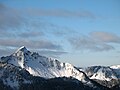
_Winter.JPG) The wintry Einstein from the west |
||
| height | 1866 m above sea level A. | |
| location | Tyrol , Austria | |
| Mountains | Tannheimer Berge , Allgäu Alps | |
| Dominance | 3.5 km → Aggenstein | |
| Notch height | 718 m ↓ Engetal | |
| Coordinates | 47 ° 31 '20 " N , 10 ° 30' 48" E | |
|
||
| rock | Summit construction main dolomite | |
| First ascent | by locals | |
| Normal way | Hiking trail from Tannheim | |

The Einstein is a mountain in the north of the Tannheimer Valley . It rises above the village of Tannheim in Tyrol . The "one" in the name of the mountain stands for the mountain's secluded location, which is separated from the neighboring elevations by deeply cut valleys ( Vilstal and Engetal ) and a flat valley watershed . The strikingly square summit rises high above its satellites. "Stone" refers to the rocky limestone summit structure, which is 1866 m above sea level. A. achieved. Heinz Groth describes the Einstein as " Tannheim's local mountain ". The height of the Einstein is 718 m , its dominance 3.5 kilometers, with Kellenspitze and Aggenstein being the reference mountains .
Hiking trails
The hike to the Einstein, on which a narrow steep path leads, promises a good all-round view of the other Tannheim mountains and the Allgäu Alps as a whole : to the north you can see the Ostallgäu Alpine foothills, to the east you can see the Aggenstein and the west walls of the Zugspitze , in the west the Wertacher Hörnle , in the south among other peaks the Gaishorn , the Rauhhorn and the Kugelhorn . Dieter Seibert speaks of a "top-class viewpoint".
There are two different accesses to the summit: the southern path leads up from Tannheim, the northern, also a little trickier, starts in the municipality of Pfronten , it then crosses the state border between the German Free State of Bavaria and the Austrian state of Tyrol north of Grän .
The tour requires surefootedness and caution when wet, because the flanks consist of steep craggy terrain .
photos
East Side
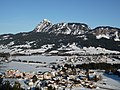
South side with Grän and Haldensee

View from the Aggenstein and the Bad Kissinger Hütte to the Einstein (snowy peak on the left)


literature
- Einstein - Felsberg over Tannheim , in: Bernd Irlinger: Ostallgäu and Tannheimer Berge . Bruckmannverlag, Munich 2006, pp. 106-107. ISBN 3-7654-4131-7 .
- Einstein , in: Dieter Seibert, Allgäuer Alpen alpin , AV-Führer , Munich 2004, 16th edition, p. 249, ISBN 3-7633-1126-2 .
- Einstein - an individualist among the Tannheimer mountains , in: Dieter Seibert, Mountain walks in the Tannheimer Tal and Jungholz - selection guide, Bergverlag Rudolf Rother, Munich 1996, 4th edition, pp. 26-27, ISBN 3-7633-4229-X .
- Einstein - the "single person" in the Tannheimer mountains , in: Dieter Seibert, Allgäu 2 (Ostallgäu and Lechtal), Bergverlag Rudolf Rother, Munich 2004, 6th edition, pp. 44–45, ISBN 3-7633-4259-1 ( there is a detailed description of the north rise)
- Einstein - even the dark side has its charms , in: Herbert Mayr, Allgäuer Alpen, Kompass Wanderführer 925, Kompass-Karten-GmbH, Rum 2005, 2nd edition, pp. 112–113, ISBN 3-85491-201-3 .
- Einstein , in: Peter Nowotny, The most beautiful mountain hikes in the Allgäu - mountain tour guide Allgäu Alps , AVA Verlag Allgäu, Kempten without year, pp. 20-21, ISBN 3-924809-95-X .
Web links
References and comments
- ↑ height of the Talwasserscheide Engetals ( 1148 m ) in tightness to SRTM data at point 47 ° 31 ' N , 10 ° 33' O .
- ^ Federal Office for Metrology and Surveying Austria: Austrian Map online (Austrian map 1: 50,000) .
- ↑ Heinz Groth, Allgäu Alps. Area guide for hikers and mountaineers, Bergverlag Rudolf Rother , Munich 1985, 3rd edition, p. 250, ISBN 3-7633-3642-7
- ↑ Dieter Seibert, Mountain Hikes in the Tannheimer Tal and Jungholz - Selection Guide, Bergverlag Rudolf Rother, Munich 1996, 4th edition, p. 26, ISBN 3-7633-4229-X