
Aggenstein
| Aggenstein | ||
|---|---|---|
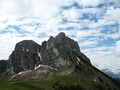
 View from the Sebenalm to the Aggenstein |
||
| height | 1986 m above sea level A. | |
| location | Border Bavaria , Germany / Tyrol , Austria | |
| Mountains | Tannheimer Berge , Allgäu Alps | |
| Dominance | 1.8 km → Brentenjoch | |
| Notch height | 266 m ↓ notch to the Brentenjoch | |
| Coordinates | 47 ° 32 '13 " N , 10 ° 33' 29" E | |
|
||
| rock | Main dolomite from the Triassic Lech Valley cover | |
| Normal way | From Grän-Enge via the Bad Kissinger hut | |

The Aggenstein is a 1,986 meter (according to German measurements: 1985 m above sea level ) high mountain in the Allgäu Alps on the border of Germany and Austria . There it is located in the Bavarian part of the Tannheim Mountains a few kilometers south of Pfronten ( Ostallgäu district ).
Location and surroundings
The gap height of the Aggenstein is at least 266 meters, its dominance 1.8 kilometers, whereby the Brentenjoch is the reference mountain in each case .
Routes to the summit
From Grän :
- Grän-Enge, Lumberg car park - Seebach - Bad Kissinger Hütte - summit (approx. 2.5 hours)
- Grän-Enge, Lumberg car park - Seebach - Seebenalpe - Tannheimer Höhenweg - Bad Kissinger Hütte - summit (approx. 3 hours)
- Grän - Füssener Jöchl - Tannheimer Höhenweg - Bad Kissinger Hütte - summit (approx. 4.5 hours, cable car support possible)
From Pfronten :
- Pfronten, Breitenbergbahn valley station - Hochalpforstweg - Platte - Böser Tritt - Bad Kissinger Hütte - summit (approx. 3 hours, cable car support possible)
- Pfronten, Breitenbergbahn valley station - Reichenbachklamm - Platte - Böser Tritt - Bad Kissinger Hütte - summit (approx. 3 hours)
- Pfronten, Breitenbergbahn valley station - Hochalpforstweg - Breitenbergbahn mountain station - Hochalpe - Langer Strich - summit (approx. 3.5 hours, cable car support possible)
- Pfronten, ski center - Tiroler Stadl - Daufa - Ostlerhütte - Breitenberg - Hochalpe - Langer Strich - summit (approx. 4 hours)
Climbing opportunities
- Aggenstein Südwandplatten and subsequent ridges (level of difficulty II-VI , very well insured)
- Aggenstein north and west face (III- - VIII-, rarely used, often wet and crumbly, often poorly secured)
- Bad Kissinger Hütte: climbing garden right next to the hut
bases
- Bad Kissinger Hut
- Breitenbergbahn mountain station
- Ostlerhütte
- Hochalphütte
- Berghaus Allgäu
photos

View from the Brentenjoch to the Aggenstein and the Bad Kissinger Hütte

Aggenstein from Grän
North face

Winter impressions


literature
Hiking guide
- Gaby Funk: Allgäu - high-altitude trails, summit destinations, via ferratas . 2nd Edition. Bruckmann Verlag, Munich 2008, ISBN 978-3-7654-4194-3
- Gaby Funk: Mountain tours for late risers in the Allgäu Alps . 2nd Edition. J.Berg Verlag, Munich 2009, ISBN 978-3-7658-4201-6
- Tobias Sessler: Mountain hikes, summit destinations and high-altitude trails in the Allgäu Alps: 60 mountain tours from Kleinwalsertal via Oberstdorf to Tannheimer Tal . Books on Demand, Norderstedt 2005, ISBN 3-8334-2643-8
- Dieter Seibert: Allgäu (Volume 2), Ostallgäu and Lechtal: 50 selected day hikes in the areas around Füssen, Pfronten and Reutte as well as in the Tannheimer Tal and Lechtal . 7th edition. Bergverlag Rother , Oberhaching 2008, ISBN 3-7633-4259-1
- Aggenstein . In: Peter Nowotny: The most beautiful mountain hikes in the Allgäu - mountain tour guide Allgäu Alps , AVA Verlag Allgäu, Kempten (pp. 10-13), ISBN 3-924809-95-X
Climbing guide
- Achim Pasold: Alpine climbing guide Allgäu: Including Tannheimer Berge . 5th edition. Panico Alpinverlag, Köngen 2006, ISBN 3-926807-59-8
Maps
- Kompass hiking, bike and ski tour map: Sheet 04 Tannheimer Tal (1: 35,000). ISBN 978-3-85491-644-4
Web links
Commons : Aggenstein - collection of images, videos and audio files
- Mountain hike Aggenstein and Tannheimer Höhenweg
- Section Bad Kissingen with further information about the Aggenstein
- Tannheim Valley
- Directions on Bergtouren-online.de
- Aggenstein mountain tour with GPS track
References and comments
- ↑ Bavarian Surveying Administration : BayernAtlas . Retrieved April 18, 2018.
- ↑ Exact value not known, stated value is a minimum value (can be up to 19 meters higher). It was determined from the distance between the contour lines (20 meters in altitude ) on a topographic map ( scale 1: 25,000).
- ^ Aggenstein Südwand , accessed on August 29, 2013.
- ^ Aggenstein north face , accessed on August 29, 2013.
