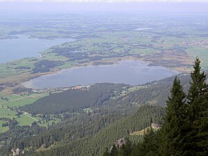
Bannwaldsee
| Bannwaldsee | ||
|---|---|---|

|
||
| Bannwaldsee from the west, in the background the Ammergau Alps . | ||
| Geographical location | Allgäu | |
| Tributaries | Buchinger Ache | |
| Drain | Mühlberger Oh | |
| Location close to the shore | Feet | |
| Data | ||
| Coordinates | 47 ° 36 '4 " N , 10 ° 46' 38" E | |
|
|
||
| Altitude above sea level | 785.9 m | |
| surface | 2.28 km² | |
| length | 2.34 km | |
| width | 1.445 km | |
| volume | 14,090,000 m³ | |
| scope | 6.79 km | |
| Maximum depth | 12.0 m | |
| Middle deep | 6.2 m | |
| PH value | 7.9 | |
| Catchment area | 21.42 km² | |
|
particularities |
Water quality : mesotrophic |
|
The Bannwaldsee is a 2.28 km² lake in the Ostallgäu district , Bavarian Swabia , Bavaria . It is located 4.5 kilometers northeast of Füssen , about a kilometer east of the Forggensee , into which it drains via the Mühlberger Ach. Large parts of the bank consist of natural silting zones. In the southeast there is a campsite and bathing areas.
The entire area of the Bannwaldsee belongs to the municipality of Schwangau ; its east bank borders on the parish halch .
ecology
The silting up and swamping of the Bannwaldsee have favored the creation of large-scale raised bog and low bog locations as well as wetlands with litter meadows , sedge beds, reed beds, as well as bog, quarry and swamp forests. Living raised bogs dominate the north bank, some of which have been degraded. Lime-rich fens occur on the west bank.
Water quality
The water quality is mesotrophic . The water renewal time is 5.2 years.
fauna
The following protected animal species inhabit the Bannwaldsee and the adjacent bank and siltation zones
- Helmet Azure Maiden (Coenagrion mercuriale)
- Scabiosa butterfly (Euphydryas aurinia)
- Dark blue antblue (Glaucopsyche nausithous)
- Narrow diaper snail (Vertigo angustior)
- Four-toothed diaper snail (Vertigo geyeri)
flora
The following habitat types that are worthy of protection occur in the area of the lake and the adjacent bank and siltation zones:
- Renatured degraded raised bogs
- Transitional and swinging lawn bogs
- Peat swamps with rush communities
- Tufa springs
- Lime-rich fens
- Living raised bogs
- Lime (semi) dry lawns and their stages of shrubbery
- Pipe grass meadows
- Moist tall herbaceous vegetation
- Lean, lowland hay meadows
- Bog forests
- Alder, ash and softwood alluvial forests
- Natural and near-natural nutrient-rich still waters with spawning or frog-bite communities
Protected areas
The lake is located in the 5.60 km² nature reserve Bannwaldsee (NSG-00495.01).
The Bannwaldsee and the surrounding wetlands are also part of the European Natura 2000 network and have been reported to the European Commission as an FFH area of the same name (size: 558 hectares, 8430-301).
The Forggensee and neighboring lakes , including the Bannwaldsee, are designated as a landscape protection area (size: 5,806 hectares, LSG-00446.01).
See also
Web links
Individual evidence
- ↑ a b c d e f Documentation of the condition and development of the most important lakes in Germany: Part 11 Bavaria (PDF; 1.7 MB)
- ↑ a b c d 8430-301 nature reserve 'Bannwaldsee' (FFH area). Published by the Federal Agency for Nature Conservation . Retrieved February 5, 2019.
- ↑ protectedplanet.net
- ↑ Ulrike Hanning: Green List of Landscape Protection Areas in Swabia. Bavarian State Office for the Environment (LfU), July 15, 2016, accessed on September 4, 2017 .


