
Schwangau
| coat of arms | Germany map | |
|---|---|---|

|
Coordinates: 47 ° 35 ' N , 10 ° 44' E |
|
| Basic data | ||
| State : | Bavaria | |
| Administrative region : | Swabia | |
| County : | Ostallgäu | |
| Height : | 796 m above sea level NHN | |
| Area : | 76.03 km 2 | |
| Residents: | 3331 (Dec. 31, 2019) | |
| Population density : | 44 inhabitants per km 2 | |
| Postal code : | 87645 | |
| Area code : | 08362 | |
| License plate : | OAL, FÜS, MOD | |
| Community key : | 09 7 77 169 | |
| LOCODE : | DE CGA | |
| Community structure: | 8 parts of the community | |
| Address of the municipal administration: |
Münchener Strasse 2 87645 Schwangau |
|
| Website : | ||
| Mayor : | Stefan Rinke ( CSU ) | |
| Location of the community of Schwangau in the Ostallgäu district | ||
  |
||


.jpg)
.jpg)
Schwangau ( dialect : Schwõ´gɘ ) is a municipality in the Swabian district of Ostallgäu . In the district Hohenschwangau the famous royal castles are Neuschwanstein and Hohenschwangau .
geography
location
Schwangau is located in the Allgäu in southern Bavaria on the Romantic Road , which ends in Füssen , four kilometers away . The altitude of the community is between approx. 770 m above sea level. NHN (Forggensee) and 2082 m above sea level. NHN (high plateau in the Ammer Mountains).
Expansion of the municipal area
The municipality consists of the districts of Schwangau and Waltenhofen. The Alpsee , Schwansee and Bannwaldsee are located in the municipality . The largest (eastern) part of the Forggensee belongs to Schwangau.
The municipality has eight officially named municipality parts (the type of settlement is indicated in brackets ):
|
|
history
Until the 18th century
Tool finds on the Frauenberg near Horn and on the north bank of the Bannwaldsee indicate that the first settlement of Schwangau dates back to the Middle Stone Age .
In the year 15 BC Roman troops under Drusus and Tiberius conquered the Alpine foothills as far as the Danube . Under Emperor Claudius , the alpine path, which probably already existed as a path, was expanded into an approx. Five meter wide road, the Via Claudia Augusta . It connected the Roman motherland with the province of Raetia. At that time, a supply unit was stationed in Füssen . Disused soldiers received small pieces of land as parting gifts from the military and entered into unions with the local population.
This is how the Roman settlement on Tegelberg, with a bathhouse from the 2nd century that has been preserved today, and the small " villae rusticae " (manor houses) near Forggen were created . In the years 284 to 305, Germanic tribes overran the country several times and left it with the collapse of the Roman Empire - presumably peacefully - around 450.
The Alemanni colonized the Schwangau area around the year 600 and farmed it. It is believed that they moved up the Lech and then began to clear in Schwangau. From this time about 130 graves are still preserved on the northern edge of Schwangau, which were discovered during the construction of a residential house in today's Alemannenweg in the 1960s.
With the beginning of Christianization in the 8th century, there were no grave goods in the graves. At this time the church in Waltenhofen was founded in 746 and the dead were buried there from then on. It was the first Christian church to the right of the Lech and was built by Saints Magnus and Tosso .
The first documentary mention of Schwangau as "Castrum Swangowe" took place in 1090. This referred to the double castle Vorder- and Hinterschwangau, on the rock of today's Neuschwanstein Castle . It was owned by the Elder's Welf . The Guelph ministerials , the Schwangau, lived on this Schwanstein. With the death of Welf VI. In 1191 the Guelph property in Schwangau fell to the Staufers , in 1268 to the empire, with which the lords of Schwangau became Imperial Knights . At this time lived the probably most famous Schwangau, the minstrel Hiltbolt von Schwangau (* approx. 1190–1256). 22 Minnelieder by him have been preserved, the dates of which are set between 1215 and 1225, which have found their way into the Heidelberger and partly into the Weingartner lieder manuscript .
From the 15th century, with the division of rule by Ulrich II von Schwangau to his four sons in 1428, the Schwangau knights, who were directly involved in the empire, could no longer get out of their financial hardship. The poet-composer Oswald von Wolkenstein , husband of Margareta von Schwangau , had to wrestle with his brothers-in-law for a long time for his wife's dowry. Mismanagement and inheritance disputes led Georg von Schwangau to transfer his inheritance, Hohenschwangau and the Frauenstein , as well as the jurisdiction to Duke Albrecht III. sold by Bavaria-Munich in 1440. The Schwangau people were now mostly the keepers of the dukes of Bavaria on Schwangau. In 1521, however, the two brothers Heinrich and Georg von Schwangau were enfeoffed again at the Reichstag in Worms with the allodes and fiefs of the Schwangau family by Emperor Charles V and thus Imperial Knights in the Swabian knightly circle . But already in 1535 they had to sell the entire property for 35,000 florins to the imperial councilor and patrician Johann Paumgartner from Augsburg . In 1536 the two brothers died, and with that the family of the Lords of Schwangau also died out.
Johann Paumgartner had the neglected Schwanstein Castle (today Hohenschwangau Castle ) rebuilt, while Vorder- and Hinterschwangau and Frauenstein continued to be neglected. In 1549 Johann Paumgartner died and the rule fell to his two sons David and Georg. In 1561 David Paumgartner pledged Hohenschwangau to Margrave Georg-Friedrich of Brandenburg-Ansbach-Kulmbach .
The margrave sold the rule to Duke Albrecht V of Bavaria in 1567 . This also brought the claims of Paumgartner's creditors and was enfeoffed with Hohenschwangau under imperial law. In 1604 Duke Max I of Bavaria received the entitlement to the imperial fiefs associated with Hohenschwangau, and Elector Ferdinand Maria of Bavaria in 1670 himself.
In addition to the turmoil of the Thirty Years' War (1618–1648), another tribulation came for the Schwangau people: the plague . It raged in 1635/1636 and greatly decimated the population. During the night the dead were carted out to the plague cemetery in St. Coloman . After this great bloodletting, the community was repopulated with immigrants from Tyrol and the Engadine . The typical Schwangau construction, "the shed", probably originates from the latter.
19th century
In the following decades, the castle in Hohenschwangau changed hands several times. During the coalition wars from 1800 to 1809 it was so badly damaged that in 1820 it could only be sold as a ruin . In 1832, Crown Prince Maximilian , who later became King Max II, acquired the ruins and had them rebuilt in neo-Gothic style based on plans and sketches by Dominicus Quaglio (1832–1836).
Maximilian's eldest son, Ludwig II of Bavaria , had Neuschwanstein Castle built on the site of the Vorder- and Hinterschwangau castles . The foundation stone was laid on September 5, 1869. The construction work was stopped in 1886 with the death of the king, so that the castle was never fully completed.
Shortly before the turn of the century, tourism arrived in Schwangau and the first pensions and hotels were built. As a result of this development, the population adjusted more and more to tourism.
20th century
In 1938, a spa park was built in Schwangau under the then mayor Pfeiffer .
Many efforts of the community over the years led to the recognition in 1926 as a health resort and in 1986 the award of the predicate health resort .
The damming of the Forggensee in 1953/1954 meant a major structural change for the community. As a result, the community lost 1,071 hectares of land, a quarter of its former area. The villages of Deutenhausen, Forggen and parts of Brunnen fell victim to the damming. With the support of BAWAG (Bayerische Wasserkraft AG) it was possible to finance the municipal water supply, part of the local sewerage, the primary school and the town hall.
Population development
| year | 1840 | 1939 | 1961 | 1970 | 1991 | 1995 | 2005 | 2010 | 2015 |
| Residents | 700 | 1524 | 2615 | 2859 | 3481 | 3415 | 3419 | 3360 | 3233 |
From 1988 to 2008, Schwangau grew by 271 inhabitants or around nine percent. Between 1988 and 2018, the municipality grew from 3,104 to 3,314 by 210 inhabitants or 6.8%.
politics
mayor
Stefan Rinke (* 1972) has been mayor since May 1, 2014; on March 15, 2020, he was the only applicant, nominated by the CSU, FDG and Free Voters, to be re-elected with 95.2% of the votes.
Municipal council
The election on March 15, 2020 had the following result:
- CSU : 6 seats (37.72%)
- Free village community : 4 seats (28.69%)
- Free voters : 4 seats (23.50%)
- SPD : 2 seats (10.08%)
The turnout was 59.24%.
coat of arms
The description of the municipal coat of arms, adopted in 1953, reads: "In red a black-armored silver swan with spread wings."
economy
The main branches of business are tourism , handicrafts , trade and agriculture .
Buildings and monuments

- Neuschwanstein Castle
- Castle Hohenschwangau
- Bullachberg Castle
- Marienbrücke
- St. Coloman Church
- Parish Church of St. Maria and Florian (Waltenhofen)

Remains of the hamlet of Forggen
Yellow wall cupboard

Typical arbor house in Schwangau

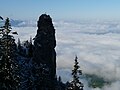
Schwangau in winter
.jpg)


Sports
There are several sports clubs in Schwangau.
In terms of sports facilities, Schwangau has a grass soccer field, tennis courts, two shooting sports facilities, two sailing boat berths on the Forggensee, a model airfield, take-off and landing area for hang-gliders and paragliders on Tegelberg , various ski lifts on Tegelberg, a cross-country ski trail that runs through wide Parts of the community area leads to the Kristalltherme with various swimming pools, via ferratas on the Tegelberg and a sports hall at the primary school in Schwangau.
Sports events that take place regularly include the Neuschwanstein Run , the Schwanseelauf, the Tegelberglauf, which was part of the 2006 German Mountain Running Championship, and the TSV Schwangau village sports festival.
Personalities
The Salvatorian Father Pankratius Pfeiffer (1872–1945), born in Brunnen, helped Roman Jews and resistance fighters to flee during the German occupation of Rome in World War II .
- Hiltbolt von Schwangau , minstrel
- Ludwig II (Bavaria) (1845–1886)
- Heinz Guderian (1888–1954), Colonel General, died in Schwangau
- Andreas Schweiger (1953–2018), biathlete
Web links
- Entry on the coat of arms of Schwangau in the database of the House of Bavarian History
- Schwangau: Official statistics of the LfStat (PDF; 1.1 MB)
Individual evidence
- ↑ "Data 2" sheet, Statistical Report A1200C 202041 Population of the municipalities, districts and administrative districts 1st quarter 2020 (population based on the 2011 census) ( help ).
- ↑ https://gemeinde.schwangau.de/buergerservice/aemter-und-einrichtungen/
- ^ Community Schwangau in the local database of the Bavarian State Library Online . Bayerische Staatsbibliothek, accessed on August 17, 2019.
- ^ Community of Schwangau, all clubs and associations in Schwangau: https://gemeinde.schwangau.de/buergerservice/vereine-und-verbaende/

Aitrang | Baisweil | Bidingen | Biessenhofen | Buchloe | Eggenthal | Eisenberg | Friesenried | Feet | Germaringen | Görisried | Günzach | Halbch | Hopferau | Irsee | Jengen | Kaltental | Kraftisried | Lamerdingen | Lechbruck am See | Lengenwang | Marktoberdorf | Mauerstetten | Nesselwang | Obergünzburg | Oberostendorf | Osterzell | Pforzen | Pfronten | Rettenbach am Auerberg | Vineyards | Vineyards on the Forggensee | Ronsberg | Roßhaupten | Backwood | Ruderatshofen | Schwangau | Seeg | Stötten am Auerberg | Stöttwang | Unterthingau | Untrasried | Waal | Forest | Westendorf