
Stöttwang
| coat of arms | Germany map | |
|---|---|---|

|
Coordinates: 47 ° 53 ' N , 10 ° 43' E |
|
| Basic data | ||
| State : | Bavaria | |
| Administrative region : | Swabia | |
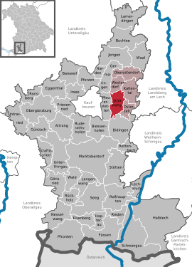
| County : | Ostallgäu | |
| Management Community : | Westendorf | |
| Height : | 726 m above sea level NHN | |
| Area : | 19.79 km 2 | |
| Residents: | 1873 (Dec. 31, 2019) | |
| Population density : | 95 inhabitants per km 2 | |
| Postal code : | 87677 | |
| Area code : | 08345 | |
| License plate : | OAL, FÜS, MOD | |
| Community key : | 09 7 77 172 | |
| Community structure: | 5 parts of the community | |
| Address of the municipal administration: |
Kirchplatz 2 87677 Stöttwang |
|
| Website : | ||
| Mayor : | Christian Schlegel ( Free Voters' Association ) | |
| Location of the municipality of Stöttwang in the Ostallgäu district | ||
  |
||


Stöttwang is a municipality in the Swabian district of Ostallgäu seven kilometers east of Kaufbeuren and a member of the Westendorf administrative community .
geography
The community is located on the western slope of the Osterzeller Ridge of the Iller-Lech gravel plates at an altitude between 696 (Gennach) and 806 m above sea level (Spitalwald). The municipality has five officially named municipal parts (the type of settlement is given in brackets ):
- Gennachhausen ( village )
- Linden ( Kirchdorf )
- Reichenbach (Kirchdorf)
- Stöttwang ( parish village )
- Thalhofen an der Gennach (village)
Gennachhausen, Linden and Thalhofen are on the Gennach River .
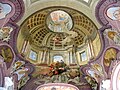
The rococo church of St. Gordian and St. Epimachus in the municipality of Stöttwang is characteristic of the village .
history
Until the church is planted
Stöttwang belonged to the Free Imperial City of Kaufbeuren. Since the Reichsdeputationshauptschluss of 1803 the place belongs to Bavaria . In the course of the administrative reforms in the Kingdom of Bavaria , today's municipality was created with the municipal edict of 1818 .
Incorporations
On April 1, 1971, in the course of the regional reform, the former municipalities of Linden, Thalhofen an der Gennach and Reichenbach were voluntarily merged to form the new municipality of Stöttwang. In 1978 this was assigned to the administrative community Westendorf .
Population development
The following figures refer to the territorial status on May 25, 1987.
| Population development | ||||||||||||||
|---|---|---|---|---|---|---|---|---|---|---|---|---|---|---|
| year | 1840 | 1900 | 1939 | 1950 | 1961 | 1970 | 1987 | 1991 | 1995 | 2000 | 2005 | 2010 | 2015 | |
| Residents | 625 | 805 | 789 | 1203 | 967 | 995 | 1350 | 1422 | 1604 | 1791 | 1867 | 1817 | 1782 | |
Stöttwang grew by 460 inhabitants or approx. 34% from 1988 to 2008, one of the top values in the Ostallgäu district. Between 1988 and 2018, the municipality grew from 1339 to 1835 by 496 inhabitants or 37%.
politics
mayor
Christian Schlegel (Free Voters' Association) has been the mayor since May 2014.
coat of arms
The coat of arms description reads: Divided; above in red a six-pointed golden star, below in blue a growing golden abbot; a palm branch and an overturned silver sword crossed diagonally on the dividing line.
Architectural monuments
Economy and Infrastructure
Economy including agriculture and forestry
According to official statistics, there were seven employees in the field of agriculture and forestry, 121 in the manufacturing sector and ten in the trade and transport sector at the place of work. In other economic areas, 30 people were employed at the place of work subject to social security contributions. There were a total of 536 employees at the place of residence subject to social security contributions. There was one company in the manufacturing sector and four companies in the main construction sector. In addition, in 1999 there were 50 farms with an agricultural area of 1197 ha, of which 1143 ha were permanent green space.
education
The following institutions exist (as of: 1999):
- Kindergartens
- 75 places in kindergarten with 75 children
- Elementary schools
- Elementary School Stöttwang-Westendorf Elementary School and Part-Secondary School I
Water supply
Stöttwang is supplied by the water supply association for the Gennach-Hühnerbach group, to which seven other neighboring communities belong. The Hochreute water supply system is located in the western part of the municipality with 3 wells from which approx. 1.4 million m³ of groundwater may be extracted per year (water law permit from January 10, 2005, limited to December 31, 2034). A water protection area has existed since the mid-1970s, which was adjusted to the state of the art in 2011 and the demand forecast up to 2040.

St Gordon and Epimachus

Steeple

Blood of christ
Dummy domes

Ceiling painting
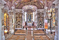
inner space


Web links
- Entry on the Stöttwang coat of arms in the database of the House of Bavarian History
- Stöttwang: Official statistics of the LfStat (PDF; 1.05 MB)
Individual evidence
- ↑ "Data 2" sheet, Statistical Report A1200C 202041 Population of the municipalities, districts and administrative districts 1st quarter 2020 (population based on the 2011 census) ( help ).
- ^ Community of Stöttwang in the local database of the Bavarian State Library Online . Bayerische Staatsbibliothek, accessed on August 17, 2019.
- ^ Wilhelm Volkert (ed.): Handbook of Bavarian offices, communities and courts 1799–1980 . CH Beck, Munich 1983, ISBN 3-406-09669-7 , p. 492 .

Aitrang | Baisweil | Bidingen | Biessenhofen | Buchloe | Eggenthal | Eisenberg | Friesenried | Feet | Germaringen | Görisried | Günzach | Halbch | Hopferau | Irsee | Jengen | Kaltental | Kraftisried | Lamerdingen | Lechbruck am See | Lengenwang | Marktoberdorf | Mauerstetten | Nesselwang | Obergünzburg | Oberostendorf | Osterzell | Pforzen | Pfronten | Rettenbach am Auerberg | Vineyards | Vineyards on the Forggensee | Ronsberg | Roßhaupten | Backwood | Ruderatshofen | Schwangau | Seeg | Stötten am Auerberg | Stöttwang | Unterthingau | Untrasried | Waal | Forest | Westendorf