
Kraftisried
| coat of arms | Germany map | |
|---|---|---|

|
Coordinates: 47 ° 47 ' N , 10 ° 28' E |
|
| Basic data | ||
| State : | Bavaria | |
| Administrative region : | Swabia | |
| County : | Ostallgäu | |
| Management Community : | Unterthingau | |
| Height : | 822 m above sea level NHN | |
| Area : | 16.23 km 2 | |
| Residents: | 846 (Dec. 31, 2019) | |
| Population density : | 52 inhabitants per km 2 | |
| Postal code : | 87647 | |
| Area code : | 08377 | |
| License plate : | OAL, FÜS, MOD | |
| Community key : | 09 7 77 144 | |
| LOCODE : | DE KFI | |
| Community structure: | 10 parish parts | |
| Address of the municipal administration: |
Reinhardsrieder Str. 10 87647 Kraftisried |
|
| Website : | ||
| Mayor : | Michael Abel (constituency of all professions) | |
| Location of the municipality Kraftisried in the Ostallgäu district | ||
  |
||


Kraftisried is a municipality in the Swabian district of Ostallgäu and a member of the Unterthingau administrative community .
geography
Kraftisried is located in the Allgäu region . There is only the Kraftisried district . The community lies between 788 m above sea level (Reichenbach) and 915 m above sea level (southern Haarberg). The municipality has 10 officially named parts of the municipality (the type of settlement is given in brackets ):
|
|
history
Until the church is planted
Kraftisried belonged to the Prince Abbey of Kempten . Since the Reichsdeputationshauptschluss of 1803 the place belongs to Bavaria . Kraftisried is probably a foundation of the Carolingian clearing period by the Franconian imperial court Thingau, which was transferred to the Kempten monastery by King Otto the Great on January 18, 943. A Reutmeister named Kraft was commissioned to clear the land west of Thingau. The name of the place can be derived from this (Ried = clearing, "clearing of power"). Later on, the Augsburg monastery also took part in the clearing. Therefore the place was divided into two main teams. On the one hand in the Stiktkemptische, administered by the Thingau nursing office, on the other hand in the bishopric Augsburg, episcopal, administered by the Oberdorf nursing office. This condition lasted until the secularization by the Bavarian state in 1803. Kraftisried was mentioned in writing for the first time in a monastery document of the Kempten monastery from 1357. In the Middle Ages, five quarter estates and several individual pieces of land, making up a total of about two estates, were fiefs of the Kemnat lordship. The mill and two farms, as well as the cabbage hut, belonged to the kemptisch leasehold rule of Kipfenberg. The prince monastery of Kempten acquired the goods of the two lords in the course of the 16th century. Gradually the settlement developed into a clustered village. In 1525 there were 30 houses. When it was deserted in 1804, 27 Kemptic and 28 Episcopal estates with houses were named. In 1809 there were 58 houses. Kraftisried has been an independent municipality since 1818.
Population development
- 1970: 627 inhabitants
- 1987: 722 inhabitants
- 1991: 750 inhabitants
- 1995: 787 inhabitants
- 2000: 771 inhabitants
- 2005: 762 inhabitants
- 2010: 745 inhabitants
- 2015: 764 inhabitants
Between 1988 and 2018, the community grew from 731 to 807 by 76 inhabitants or 10.4%.
politics
mayor
Mayor is Michael Abel (electoral community of all professions). His predecessor was Jutta Breitenmoser (electoral community of all professions) since 2008. Siegfried Mayer is the second mayor, and Manfred Allgaier is the third.
coat of arms
Blazon : In red a striding, gold-armored silver griffin.
Architectural monuments
Soil monuments
Economy including agriculture and forestry
Kraftisried is known nationwide because of the animal body disposal facility TBA-Kraftisried, which also picks up large animals such as cows, horses, donkeys, etc. In 1998 there were 24 in agriculture and forestry, 233 in manufacturing and 55 in trade and transport at the place of work. In other economic sectors, 244 people were employed at the place of work subject to social insurance contributions. There were 1,346 employees at the place of residence subject to social security contributions. There were none in manufacturing (as well as mining and quarrying of stones and earth), and nine in the main construction trade. In addition, there were 63 agricultural holdings in 1999 with an agriculturally used area of 1,467 hectares. 1,055 hectares of which were arable land.

Berleberg from the northeast

Kempter Forest near Berleberg

Farm with Arma-Christi cross

Kraftisried with Haarberg (915 m)

Luitzenmühle - Upper Pond
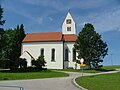
Parish church

Rectory

Raiggers chapel with Zugspitze

Raiggers from the north

After Schweinlang

Pig long from the east

Chapel near Schweinlang


Web links
- Entry on the Kraftisried coat of arms in the database of the House of Bavarian History
- Kraftisried: Official statistics of the LfStat (PDF; 1.05 MB)
Individual evidence
- ↑ "Data 2" sheet, Statistical Report A1200C 202041 Population of the municipalities, districts and administrative districts 1st quarter 2020 (population based on the 2011 census) ( help ).
- ↑ Kraftisried community in the local database of the Bavarian State Library Online . Bayerische Staatsbibliothek, accessed on August 17, 2019.
- Jump up ↑ http://www.oberallgaeu.org/gesundheit_ Konsumerschutz/tiere/ Tierkoerperbesichtung.html

Aitrang | Baisweil | Bidingen | Biessenhofen | Buchloe | Eggenthal | Eisenberg | Friesenried | Feet | Germaringen | Görisried | Günzach | Halbch | Hopferau | Irsee | Jengen | Kaltental | Kraftisried | Lamerdingen | Lechbruck am See | Lengenwang | Marktoberdorf | Mauerstetten | Nesselwang | Obergünzburg | Oberostendorf | Osterzell | Pforzen | Pfronten | Rettenbach am Auerberg | Vineyards | Vineyards on the Forggensee | Ronsberg | Roßhaupten | Backwood | Ruderatshofen | Schwangau | Seeg | Stötten am Auerberg | Stöttwang | Unterthingau | Untrasried | Waal | Forest | Westendorf