
Ruderatshofen
| coat of arms | Germany map | |
|---|---|---|

|
Coordinates: 47 ° 49 ' N , 10 ° 35' E |
|
| Basic data | ||
| State : | Bavaria | |
| Administrative region : | Swabia | |
| County : | Ostallgäu | |
| Management Community : | Biessenhofen | |
| Height : | 728 m above sea level NHN | |
| Area : | 33.52 km 2 | |
| Residents: | 1763 (Dec. 31, 2019) | |
| Population density : | 53 inhabitants per km 2 | |
| Postal code : | 87674 | |
| Area code : | 08343 | |
| License plate : | OAL, FÜS, MOD | |
| Community key : | 09 7 77 167 | |
| LOCODE : | THAT ONE | |
| Community structure: | 12 parts of the community | |
| Association administration address: | Füssener Str. 12 87640 Biessenhofen |
|
| Website : | ||
| Mayor : | Johann Stich ( general electoral apple string ) | |
| Location of the municipality of Ruderatshofen in the Ostallgäu district | ||
  |
||


Ruderatshofen is a municipality in the Swabian district of Ostallgäu and a member of the Biessenhofen administrative community .
geography
The community is located in the northeastern Allgäu , about 7 km southwest of Kaufbeuren , at an altitude between 711 m above sea level on the Kirnach near Heimenhofen and 863 m above sea level on the Sattlersbuckl.
It has 12 officially named parts of the municipality (the type of settlement is given in brackets ):
|
|
There are the districts Apfeltrang and Ruderatshofen:
- District Ruderatshofen with Geisenhofen, Heimenhofen, Hiemenhofen, Immenhofen and Leichertshofen
- Marking Apfeltrang with Dionis, Fleischer, Fuchs, Hefele and Nettengrub
Lost places in the municipality are Königsberg (around 1900) and Wellenhofen (before 1404).
history
Until the church is planted
The place was first mentioned in 839 as a place in the Keltensteingau as "Hruodoldishoua". Ruderatshofen belonged to the bishopric of Augsburg . With the Reichsdeputationshauptschluss of 1803, the place came to Bavaria. In the course of the administrative reforms in the Kingdom of Bavaria , today's municipality was created with the municipal edict of 1818 .
Territorial reform of the 1970s
Until the municipal reform , Ruderatshofen belonged to the Marktoberdorf district . This was redesigned and expanded in 1972 and renamed the Ostallgäu district in 1973 . On May 1, 1978, the previously independent community of Apfeltrang was incorporated into Ruderatshofen. On January 1, 1982, the former Wenglingen district of Apfeltranger with the wastes Lohbauer and Unger broke away from the community by referendum and was ceded to the neighboring community of Aitrang .
Population development
Ruderatshofen grew by 340 inhabitants or approx. 24% from 1988 to 2008. Between 1988 and 2018 the municipality grew from 1,436 to 1804 by 368 inhabitants or by 25.6%.
|
|
|
Source: BayLSt
politics
mayor
The mayor is Johann Stich (general voter base. Apfeltrang). In 2002 he became the successor to Wilhelm Kunstin ( Free Association of Voters ).
coat of arms
The description of the coat of arms reads: "Split of red and silver, behind a red diagonal bar covered with a golden grid".
Architectural monuments
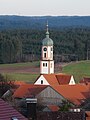
In the center of Ruderatshofen is the parish church of St. Jakobus , in the Gothic style as well as the church of St. Michael with a baroque interior .
Economy and Infrastructure
Economy including agriculture and forestry
In 1998, according to official statistics, there were 26 employees in the field of agriculture and forestry, 152 in the manufacturing sector and 20 in the field of trade and transport at the place of work. In other economic areas, 80 people were employed at the place of work subject to social security contributions. There were 481 employees at the place of residence subject to social security contributions. There were none in manufacturing and four in construction. In addition, there were 83 farms in 1999 with an agricultural area of 2024 ha.
traffic
Ruderatshofen is close to the Munich – Lindau railway line . The trains pass the place without stopping.
education
In 1999 the following institutions existed:
- Kindergartens: 75 kindergarten places with 69 children
- Primary schools: Primary school with approx. 100 pupils, which forms a school community with the Aitrang primary school
Others
In Ruderatshofen there is the custom of the knocker's day . The local children, mostly of primary school age, go from house to house on the Thursday before the first Advent to announce the upcoming Advent season. They receive sweets as gifts for reciting the traditional saying. The custom is only observed in Ruderatshofen itself; it is now extinct in the other districts. In addition to the children themselves, this custom is particularly popular with the elderly in the village, who are reminded of their own childhood and can get in touch with the children.
Registered clubs:
- Ruderatshofen Music Association
- Battle Community Ruderatshofen eV
- Shooting club "Der Rotensteiner" eV Ruderatshofen
- Immenhofen eV tennis club
- Turn- und Sportverein eV Ruderatshofen
Apple strand
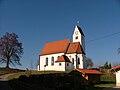
Church in Immenhofen

Immenhofen from the north

Ruderatshofen from the east

Fabulous way in Ruderatshofen

Walburga Chapel


Web links
- Entry on the coat of arms of Ruderatshofen in the database of the House of Bavarian History
- Ruderatshofen: Official statistics of the LfStat (PDF; 1.05 MB)
Individual evidence
- ↑ "Data 2" sheet, Statistical Report A1200C 202041 Population of the municipalities, districts and administrative districts 1st quarter 2020 (population based on the 2011 census) ( help ).
- ^ Community of Ruderatshofen in the local database of the Bayerische Landesbibliothek Online . Bayerische Staatsbibliothek, accessed on August 17, 2019.
- ↑ a b Federal Statistical Office (ed.): Historical municipality register for the Federal Republic of Germany. Name, border and key number changes in municipalities, counties and administrative districts from May 27, 1970 to December 31, 1982 . W. Kohlhammer, Stuttgart / Mainz 1983, ISBN 3-17-003263-1 , p. 779 and 815 .

Aitrang | Baisweil | Bidingen | Biessenhofen | Buchloe | Eggenthal | Eisenberg | Friesenried | Feet | Germaringen | Görisried | Günzach | Halbch | Hopferau | Irsee | Jengen | Kaltental | Kraftisried | Lamerdingen | Lechbruck am See | Lengenwang | Marktoberdorf | Mauerstetten | Nesselwang | Obergünzburg | Oberostendorf | Osterzell | Pforzen | Pfronten | Rettenbach am Auerberg | Vineyards | Vineyards on the Forggensee | Ronsberg | Roßhaupten | Backwood | Ruderatshofen | Schwangau | Seeg | Stötten am Auerberg | Stöttwang | Unterthingau | Untrasried | Waal | Forest | Westendorf